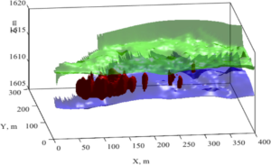
The new method (Wainwright et al., Water Resources Research) can be used to map biogeochemical hotspots in a spatially extensive and non-invasive manner, and is particularly useful for developing and parameterizing 3D biogeochemical models. Being able to map such hotspots will enable scientists to quantify the impact of floodplain subsurface processes on biogeochemical cycling through the terrestrial system and associated water quality exports to rivers.

A three-dimensional estimation of subsurface geological layers (green and purple layers) and the naturally reduced zones (red) obtained using the new method at the Rifle Colorado study site. The region shown is the modeling domain, and the estimates obtained were used to parameterize a reactive transport model.
Summary
In floodplain environments, naturally reduced zones (NRZ) are considered to be common biogeochemical hotspots that have distinct microbial and geochemical characteristics. Although important for understanding their role in mediating floodplain biogeochemical processes, mapping the subsurface distribution of NRZs over the dimensions of a floodplain or larger is challenging, as conventional wellbore data are typically spatially limited and the distribution of NRZs is heterogeneous. In this study, the authors present an innovative methodology for the probabilistic mapping of NRZs within a three-dimensional (3D) subsurface domain using induced polarization imaging, which is a non-invasive geophysical technique. Measurements consisted of surface geophysical surveys and drilling-recovered sediments, both acquired at the U.S. Department of Energy field site near Rifle, CO. Inversion of surface time-domain induced polarization (TDIP) data yielded 3D images of the complex electrical resistivity, in terms of magnitude and phase, which are associated with mineral precipitation and other lithological properties. To estimate the spatial distribution of NRZs, the team developed a Bayesian hierarchical model to integrate the geophysical and wellbore data. Results showed that the integration of geophysical imaging and wellbore data using this proposed approach was capable of mapping spatially heterogeneous interfaces and NRZ distributions. As described by a follow-on paper, the geophysical estimates were subsequently used to parameterize a reactive transport model, to predict floodplain biogeochemical cycles and river export.
