JPL/NASA Airborne Snow Observatory (ASO)
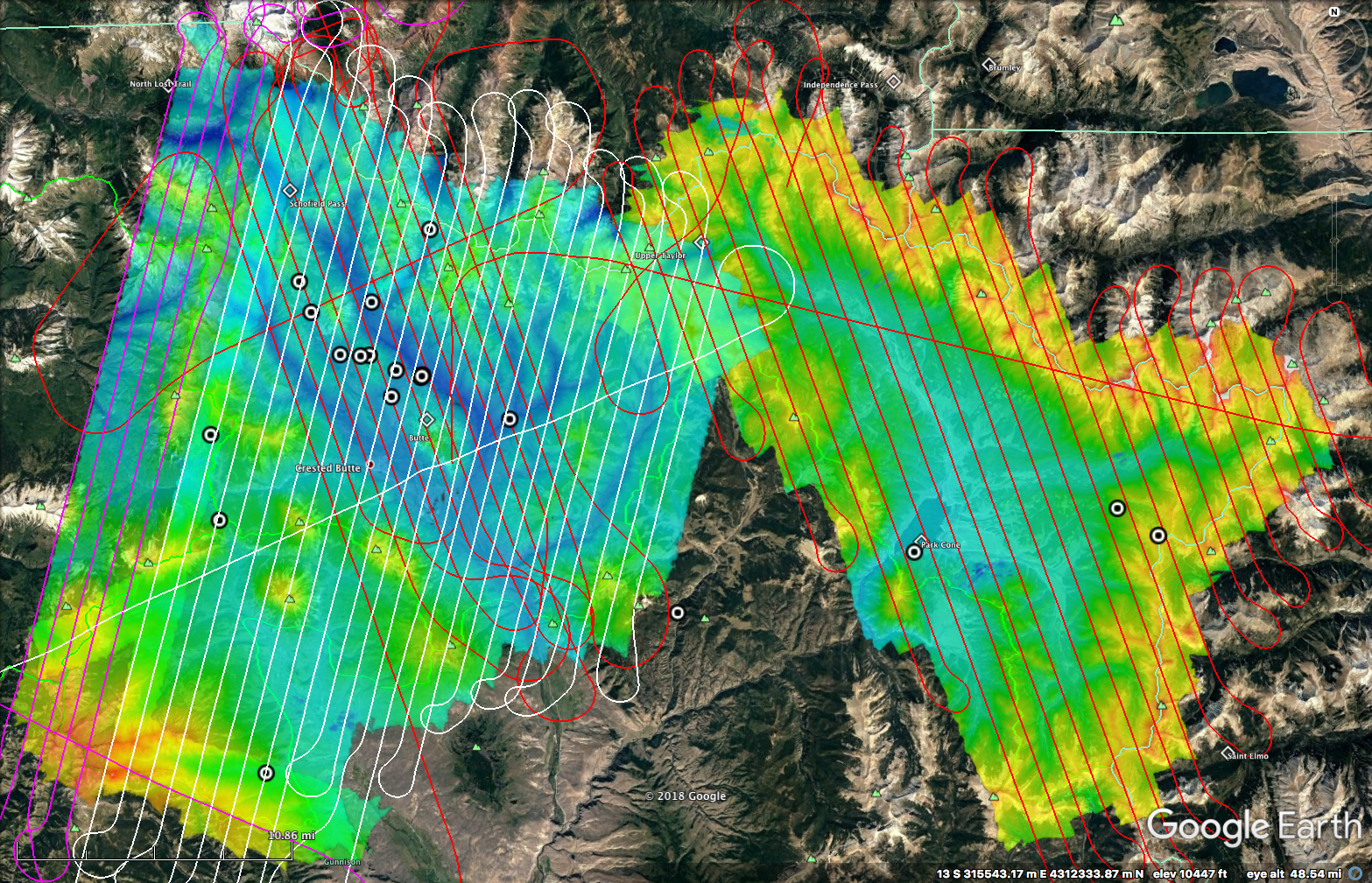
With generous financial support from the State of Colorado Water Conservation Board (CWCB), as well as critical guidance and input from Frank Kugel and John McClow of the Upper Gunnison River Water Conservancy District, the first of two “snow-on” ASO overflights of the East River, Taylor River, and Ohio Creek watersheds has been completed. The first flight was designed to coincide with so-called “peak snow water equivalent (SWE)” and took place over the last 2 days of March and first of April. Concomitant with this overflight, 18 snow pits were dug in order to have direct confirmation of snow depth and SWE at locations throughout the area of investigation. Both the flight lines (red, white, pink paths) and snow pits (bullseye circles) are included in the attached / embedded figure.
Special thanks to the team of snow samplers who worked to both coordinate and execute the sampling: Rosemary Carroll, Wendy Brown, Tony Brown, Jeff Deems, Anna Ryken, and Mike Morse. Without their help, it would have been impossible to have collected the 18(!!) pits covering an area of many hundreds of square kilometers over an elevation range from ca. 8,700-ft to 12,000-ft.
In particular, Dr. Jeff Deems (CU-Boulder) — a key member of the JPL/NASA ASO team and an incredible scientific resource for our extended Watershed SFA Team — was instrumental in coordinating and scheduling the ASO overflight, ensuring the best quality data that weather conditions would allow, as well as personally assisting with digging snow pits, which as many know is something of a “Deems speciality”. Again, without Jeff’s help in executing this work, we’d have struggled to be as productive as we were as regards ASO at East River both on this flight and those in the future.
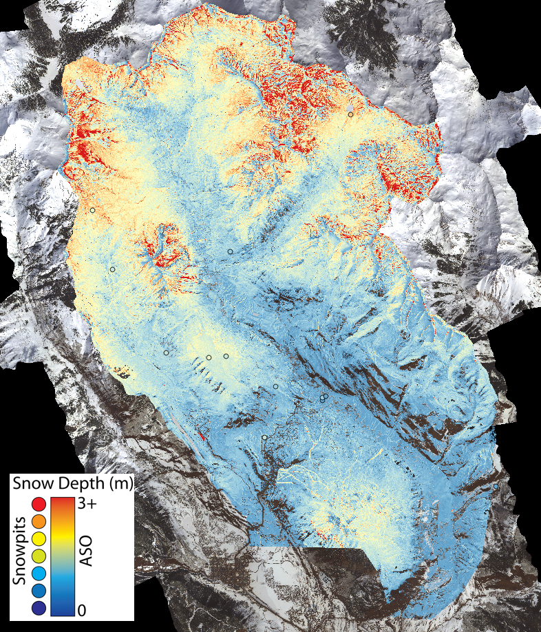
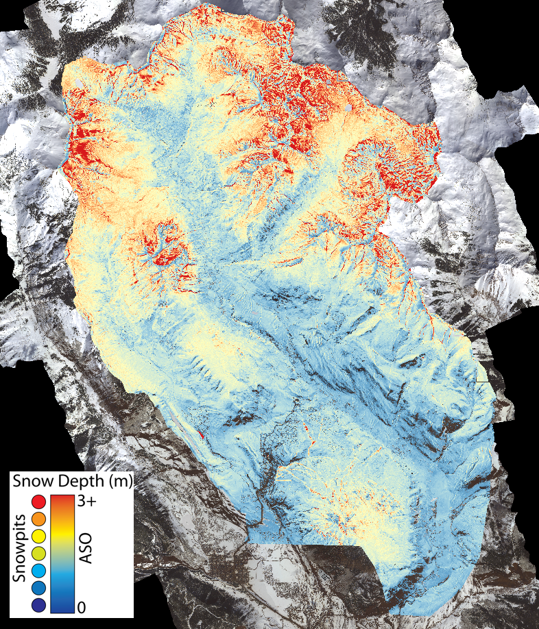
Additionally, Jeff has provided some preliminary images of snow depths associated with the boundaries of the 2016 ASO overflight. As a reminder, snow depths are calculated via difference in LiDAR derived surface elevations measured between “snow on” and “snow free” overflights. The Watershed SFA had already collected high-resolution “snow free” LiDAR data over a limited area, which allowed for a single “snow on” ASO flight in 2016 to determine snow depths within the East River main stem and WA Gulch drainages. In contrast, we do not yet have high-resolution LiDAR data collected over the much larger area of investigation associated with the East River-Taylor River-Ohio Creek system. This data — again through generous support from the state of Colorado — will be collected in September 2018, so we will have to wait until then for the larger spatial scale maps of snow depth and SWE once that “snow free” dataset is collected.
In the interim, Jeff has produced a map of the 2018 snow depths measured two weeks ago within the East River main stem and WA Gulch drainages along with the companion map for 2016. Those images are below. Toggling between the two shows quite clearly the differences between snow conditions in 2016 (average year) and 2018 (low snowpack year). The open circle symbols on the 2018 map correspond to the snow pits that were dug in association with the overflight.
A second “snow on” ASO flight is planned for mid-May of this year to assess late season snow retention as a function of both elevation and landscape position. The ability to have two time points that track the falling limb of SWE is especially exciting as it should really assist with coupling this year’s datasets to improved runoff forecast modeling approaches — although we’ll have to rely on backcast modeling this year due to the need to collect the requisite “snow free” datum in September once runoff is already completed.
Early snowmelt manipulation experiments
As most are aware, this year was our first season of experimentally manipulating snow pack along an elevation gradient to induce early snowmelt relative to adjoining control plots. The video below provides a better visual depiction of what the manipulation experiments look like at our Pumphouse hillslope intensive study site (lower montane); similar manipulations are occurring at our upper montane, lower subalpine, and upper subalpine sites. A suite of ground-based measurements are currently underway to examine the consequences of early melt on flows of water and nutrients within the plots, as well as the consequences for subsurface microbial activity and plant phenological behavior. Airborne characterization approaches are also planned, with the first round of UAV-based measurements over the manipulated and control plots planned for next week.
Pat Sorenson (LBNL) has been providing daily reports of the snow melt progression, as he’s been actively sampling for the past week-plus and will continue to do so over the next week. Pat will have an opportunity to brief this group once the dust has settled — or rather once the snow has melted — next month during our next Science Community Call. Briefly, Pat has been noting that although the snow pack continues to consolidate, settle and melt, the soils have remained quite dry and largely frozen except for the shallowest depths. He notes that the soils are very dry to a depth of ca. 30-cm, with the persistent frozen soil layers likely inhibiting infiltration. These frozen layers were likely more extensive this season due to the late arrival of snow and its insulating effect. So we’re actually getting something of a two-for-one this year, given (a) low seasonal snowpack and (b) late arriving snow, which has led to a deeper frozen soil profile than typical. Combined with the early snowmelt manipulations along the elevation gradient, the project will soon have an incredibly rich experimental dataset to examine for the next year until we do it all again. Very exciting and again more updates to follow.
NEON Airborne Observation Platform (AOP) planning
As everyone on this list has been briefed on plans for the NEON AOP overflights and been solicited for their interest and involvement, I won’t belabor this update, Rather, I just want to note the hard work of Dana Chadwick, Nicola Falco and Haruko Wainwright in pushing forward with all the details regarding the sampling plan and coordinating with NEON on all of the flight details. Due to aircraft availability issues on NEON’s end, we’re now locked into the last two weeks of June, with a focus on the last week for performing the overflights. We’d originally hoped to have the first week of July available, but as noted, the aircraft simply isn’t available. Given the low snowpack and presumed early natural melt, we feel that for the lower elevations (lower and upper montane) the last week of June should work well insofar as meadow peak or near peak greenness is concerned. Of course, we’re dealing with a natural system here — heavy, high elevation snow warnings are again in effect for tonight and tomorrow — so we’ll just need to wait and see what June brings us in terms of a slightly advanced growing season and its ability to coincide with NEON’s timetable.