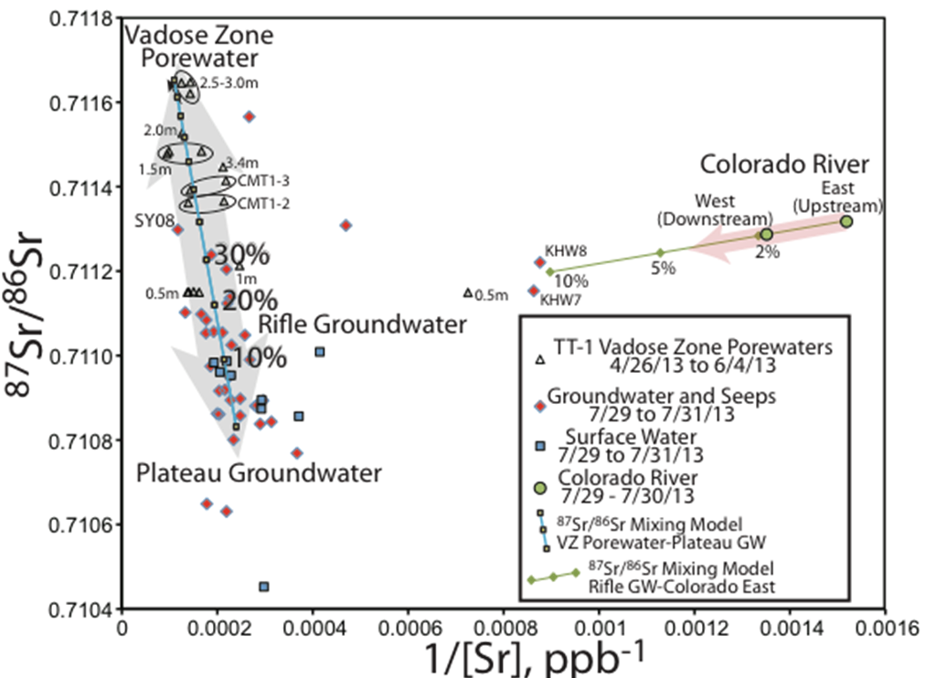
Figure 1. 87Sr/86Sr vs 1/[Sr] showing the mixing relationships between vadose zone porewater and groundwater. Blue line shows the mixing model of vadose zone water with upgradient groundwater with bold numbers representing the percentage of vadose zone water in the local aquifer.
A key component of understanding the connection between groundwater quality and the vadose zone (the water unsaturated region above the water table) is the movement of water from the surface to the aquifer (recharge). Measurements of the natural isotopic composition of Sr were used to assess the effect of local topography on groundwater recharge across a semi-dry riparian floodplain in the Upper Colorado River Basin.
This work demonstrates the use of 87Sr/86Sr (Sr isotopes) to measure groundwater recharge through analysis of porewater and groundwater samples from the vadose zone. The study resulted in an understanding how the microtopography of the Rifle Site affects the hyper-local variation in the downward movement of vadose-zone porewater that may carry nutrients and contaminants to groundwater.
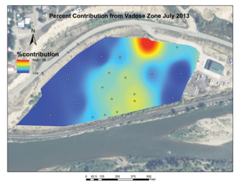
Figure 2. “Heat” map of the percentage contribution of vadose water to the Rifle floodplain aquifer based on the Sr isotopic mixing model.
Summary
Over time, loose sand, clay, silt, gravel or similar unconsolidated, or “alluvial” material is deposited by water into alluvial aquifers. Recharge of alluvial aquifers is a key component in understanding the interaction between floodplain vadose zone biogeochemistry and groundwater quality. The Rifle Site (a former U-mill tailings site) adjacent to the Colorado River is a well-established field laboratory that has been used for over a decade for the study of biogeochemical processes in the vadose zone and aquifer. This site is exemplary of both a riparian floodplain in a semiarid region and a post-remediation U-tailings site. The authors use Sr isotopic data for groundwater and vadose zone porewater samples to build a mixing model for the fractional contribution of vadose zone porewater (i.e. recharge) to the aquifer and to assess its distribution across the site. The vadose zone porewater contribution to the aquifer ranged systematically from 0% to 38% and appears to be controlled largely by the microtopography of the site. The area-weighted average contribution across the site was 8%, corresponding to a net recharge of 7.5 cm. Given a groundwater transport time across the site of ~1.5 to 3 years, this translates to a recharge rate between 5 and 2.5 cm/yr, and with the average precipitation to the site, implies a loss from the vadose zone due to evapotranspiration of 83% to 92%.
Citation
Christensen, J. N., et al. (2018), Using strontium isotopes to evaluate the spatial variation of groundwater recharge, Sci Total Environ, 637-638, 672-685, DOI: 10.1016/j.scitotenv.2018.05.019.
