Berkeley Lab

State-of-the-Knowledge: Linking Hydrological and Biogeochemical Processes in Riparian Corridors

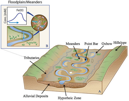
(A) The riparian corridors include various subsystems, such as hyporheic zones, meanders, wetlands, and lagoons, all of which impact river water quality (modified from Natural levees, Pearson Prentice Hall, Inc.). (B) A zoomed-in view highlights the importance of temporal dynamics within an intrameander region.

Rivers and adjacent landscapes are important parts of the Critical Zone. They serve as integrators of the hydrologic and biogeochemical cycles, constituting the primary pathways for geochemical exports from watersheds. Thus, they exert primary control on determining the downstream river water quality. The net geochemical export of metals and nutrients from watersheds depends strongly upon hydrological exchanges and biogeochemical transformations at the terrestrial–aquatic interfaces and riparian corridors. It is critical to link hydrological and biogeochemical processes in riparian corridors so as to understand how Critical Zone processes regulate future water quantity and quality for sustainable management. Here we invited theoretical and data-driven contributions that can advance the predictive understanding of riparian corridor processes.

Riparian corridors include various subsystems, such as hyporheic zones, meanders, wetlands, and lagoons, all of which impact river water quality. These subsystems demonstrate distinct biogeochemical potential depending upon their hydrologic connectivity to the main channel. However, several hurdles must be overcome to improve the predictive capability of riparian corridor processes across scales. This Research Topic aimed to enhance our understanding and predictive capability related to linked hydrological and biogeochemical processes in riparian corridors. We received contributions across a wide spectrum of topics, including hydrologic exchange and river connectivity as well as geochemical exports of carbon, nitrogen, colloids, and microbial dynamics. These topics also involved novel method development, new observational networks, advanced mechanistic modeling, and the use of artificial intelligence and machine learning approaches. Below, we briefly synthesize these contributions under two groups focused on dynamic hydrologic connectivity and microbial and physical controls on spatial patterns in river corridors.

Summary

Over the past several decades, the complexity of rivers and their adjacent environments and the important roles that they play in watershed function have been increasingly recognized. The large number of contributions to this Research Topic reflect continued high interest in understanding and quantifying the interactions between hydrological, microbial, and biogeochemical processes that underlie ecological health and water quality in these critical systems across spatiotemporal scales. It is particularly encouraging to see that hydrological connectivity has received considerable attention in this Research Topic to unravel the conundrum of high biogeochemical activity in riparian corridors. However, it is important to realize that there is no consensus about the definition of hydrological connectivity across fields. Further, we need to acknowledge the wide range of complexity of dynamic hydrological connectivity appropriately to enhance process understanding of riparian corridors. Finally, we expect that emerging technologies, radical collaboration, new constructs, and open science principles will keep transforming predictive capabilities of hydrobiogeochemical behavior of riparian corridors.

Citation

Dwivedi D, Godsey SE and Scheibe TD (2021) Editorial: Linking Hydrological and Biogeochemical Processes in Riparian Corridors. Front. Water 3:693763. doi: 10.3389/frwa.2021.693763

Hidden processes during seasonal isolation of a high-altitude watershed

Conceptual model of biogeochemical processes within the ER study site.

Our understanding of biogeochemical processes including surface-subsurface flux between the hyporheic zone and overlying water column is reduced where sample acquisition is difficult or impossible. Potentially deterministic changes to ecosystem function occur during such intervals, such as the onset of a seasonal change, over an extended quiescent period, or when extreme events (e.g., storms or rapid thaws) punctuate a temporal record. High-altitude locations, such as where headwater streams are often located, are archetypical in this regard as they may be difficult to reach under the best conditions and are nearly impossible to reach when events that are linked to seasonal inclemency restrict access or defy our ability to time data collection with episodic events. In these cases, our understanding of ecosystem function can come through approaches that employ continuous measurements.

This research defines how to address key data gaps in our current understanding of watershed biogeochemistry during seasonal inaccessibility. Continuous, autonomous sampling using the OsmoSampler produces reliable measurements of geochemistry and microbiology and may be applied in diverse environments to capture previously hidden biogeochemical processes where access is limited or impossible.

Summary

Biogeochemical processes capable of altering global carbon systems occur frequently in Earth’s Critical Zone–the area spanning from vegetation canopy to saturated bedrock– yet many of these phenomena are difficult to detect. Observation of these processes is limited by the seasonal inaccessibility of remote ecosystems, such as those in mountainous, snow- and ice-dominated areas. This isolation leads to a distinct gap in biogeochemical knowledge that ultimately affects the accuracy and confidence with which these ecosystems can be computationally modeled for the purpose of projecting change under different climate scenarios. To examine a high-altitude, headwater ecosystem’s role in methanogenesis, sulfate reduction, and groundwater- surface water exchange, water samples were continuously collected from the river and hyporheic zones (HZ) during winter isolation in the East River (ER), CO watershed. Measurements of continuously collected ER surface water revealed up to 50 μM levels of dissolved methane in July through September, while samples from 12 cm deep in the hyporheic zone at the same location showed a spring to early summer peak in methane with a strong biogenic signature (<65 μM, δ13C-CH4, −60.76‰) before declining. Continuously collected δ18O-H2O and δ2H-H2O isotopes from the water column exhibited similar patterns to discrete measurements, while samples 12 cm deep in the hyporheic zone experienced distinct fluctuations in δ18O-H2O, alluding to significant groundwater interactions. Continuously collected microbial communities in the river in the late fall and early winter revealed diverse populations that reflect the taxonomic composition of ecologically similar river systems, including taxa indicative of methane cycling in this system. These measurements captured several biogeochemical components of the high-altitude watershed in response to seasonality, strengthening our understanding of these systems during the winter months.

Citation

Buser-Young, J. Z., Lapham, L. L., Thurber, A. R., Williams, K. H. & Colwell, F. S. Hidden Processes During Seasonal Isolation of a High-Altitude Watershed. Front. Earth Sci. 9, (2021). https://doi.org/10.3389/feart.2021.666819

Meander-bound Floodplains as a Scaling Motif for understanding how the Soil Microbiome influence Watershed Biogeochemical Cycles

Taxa detected across samples (a). A core floodplain microbiome includes abundant Betaproteobacteria (b), and 42 genomes (c; teal) present in > 89 samples with a low coefficient of variation of abundance (d), not associated with any given floodplain (e; brown).

We studied the most abundant microorganisms (microbiome) in 130 topsoil samples from three meander-bound floodplains along the East River, CO during a period of low river flow and over two consecutive years. We reconstructed 248 draft quality genomes (at the sub-species level) from these samples. DNA (metagenomes) and RNA (metatranscriptome) sequences revealed the presence of bacteria that are commonly found across the floodplains over time. Despite the very high microbial diversity and complexity of the soils, ~15% of species were detected in two consecutive years, and approximately one third of the representative genomes were detected with similar levels of abundance across all three locations. The capacities for aerobic respiration, aerobic CO oxidation (and other small molecules), and thiosulfate oxidation were enriched in these microorganisms. However, the most active genes at the time of sampling were involved in nitrification, methanol and formate oxidation, and nitrogen and CO2 fixation. Our results highlight the prominence of sulfur, nitrogen, and one-carbon metabolism in the watershed.

We were able to reconstruct hundreds of microbial genomes from complex soil samples. We found that soils bounded by individual river meanders capture processes that occur in soils bounded by other meanders along the river corridor. This is important, given that there is a need to understand microbially-mediated biogeochemical transformations, which occur at the millionth of a meter scale, at the tens to hundreds of kilometer scale of watershed ecosystems. The presence of the same bacteria (~ 15%) over two consecutive years, combined with differences between common capacities and important capacities at the time of sampling, suggests that the floodplain soil microbiome is versatile and can respond to natural disturbances (e.g., flooding resulting from spring snowmelt).

Summary

Meander-bound floodplains appear to serve as scaling motifs that predict aggregate capacities for biogeochemical transformations in floodplain soils. We identified a core floodplain microbiome that was consistent across floodplains and that was enriched in capacities for aerobic respiration, aerobic CO (and other small molecules) oxidation, and thiosulfate oxidation with the formation of elemental sulfur. Systematic patterns of gene abundance based on sampling position relative to the river were not detected. The most highly transcribed genes in the middle floodplain were amoCAB and nxrAB (for nitrification) followed by genes involved in methanol and formate oxidation, and nitrogen and CO2 fixation. Additionally, low soil organic carbon correlated with high activity of genes involved in methanol, formate, sulfide, hydrogen, and ammonia oxidation, nitrite oxidoreduction, and nitrate and nitrite reduction. While widely represented genetic capacities did not predict in situ activity at one time point, they defined a reservoir of biogeochemical potential available as conditions change and suggests the value of meanders as a scaling motif to improve prediction of watershed biogeochemistry.

Citation

Matheus Carnevali, P.B., Lavy, A., Thomas, A.D. et al. Meanders as a scaling motif for understanding of floodplain soil microbiome and biogeochemical potential at the watershed scale. Microbiome 9, 121 (2021). https://doi.org/10.1186/s40168-020-00957-z

Williams interviewed for Carbondale, CO newspaper on Grizzly Creek fire

SFA Field Deputy Ken Williams was interviewed for the Sopris Sun, a newspaper based out of Carbondale, CO. Williams discussed how the Grizzly Creek fire can be a useful test case for understanding how wildfire affects water quality and nutrient cycling as well as different forest types. Read more »

The Colorado East River Community Observatory Data Collection

A visual representation of the diverse infrastructure and heterogeneous data collection activities at the East River Watershed. Figure from Kakalia et al. (2021)

The Science

The U.S. Department of Energy’s East River Community Observatory located in the East River watershed, Colorado, USA is a representative mountainous, snow-dominated system containing a diverse collection of sensors, water quality stations, experimental plots, and sample collection sites paired with remote sensing measurements and modeling activities. Data generated at the site are used to examine watershed system behavior and the impact of environmental perturbations, such as drought and early snowmelt, and are broadly relevant to the study of mountainous systems worldwide. Over 70 datasets are presently publicly available from multiple data repositories, with all having an open data policy.

The Impact

Hydro-biogeochemical data generated at the East River watershed are made publicly available for use by the global scientific community, allowing for collaboration across institutions and Federal and State Agencies. The co-located, interdisciplinary data collected at the East River watershed provide a comprehensive view of the environmental processes underlying watershed system function. Data types can be combined to find correlations between hydrological, biological, and chemical processes, with subsequent data analyses used to advance a predictive understanding of water quality and quantity in mountainous regions across the United States.

Summary

Research conducted at the East River (ER) watershed is broadly representative of mountainous headwater systems given the diversity of environmental gradients encompassed by its four principle drainages: East River, Washington Gulch, Slate River, and Coal Creek. The ER has both long-term and spatially-extensive observations and experimental campaigns carried out by the Watershed Function Scientific Focus Area (SFA) and researchers from over 30 organizations who conduct cross-disciplinary, process-based investigations and modeling of watershed system function. Collectively, the SFA and its collaborators generate diverse datasets including hydrological, (bio)geochemical, climate, vegetation, geophysical, microbiological, and remote sensing data. Additionally, predictive modeling datasets, including inputs, outputs and preprocessing codes are generated from numerical simulations of different watershed subsystems and their aggregated behavior. This paper highlights the acquisition and management of these diverse data products and describes where 71 public datasets can be accessed.

Citation

Kakalia, Z., Varadharajan, C., Alper, E., Brodie, E. L., Burrus, M., Carroll, R. W. H., Christianson, D. S., Dong, W., Hendrix, V. C., Henderson, M., Hubbard, S. S., Johnson, D., Versteeg, R., Williams, K. H., & Agarwal, D. A. (2021). The Colorado East River Community Observatory Data Collection. Hydrological Processes, 35(6), e14243. https://doi.org/10.1002/hyp.14243

Impact of agricultural managed aquifer recharge practices on groundwater quality

Denitrification rates under different stratigraphic configurations and AgMAR management scenarios – S1: All-at-once application (68 cm; once over 4 weeks); S2: Incremental application (17cm; 1x per week); and S3: Incremental application (17cm; 2x per week)

This is the first-of-its-kind study to quantify how legacy nitrogen in agricultural environments responds to changing hydrologic application rates and frequencies under AgMAR.

Scientists, engineers and practitioners seeking to apply AgMAR will find a description of water quality response under different stratigraphic configurations, antecedent moisture conditions and depth to water table.

Summary

AgMAR is a promising management strategy wherein surface waters are used to intentionally flood agricultural lands with the purposes of recharging underlying groundwater. However, it is not yet clear how legacy nitrogen that has been built up over the years from fertilizer use in these settings may respond to AgMAR practices, and more importantly, if flooding agricultural sites will enhance nitrate transport to the groundwater or attenuate it by supporting in situ denitrification. This study therefore uses a mechanistic model to evaluate the effects of different AgMAR management strategies (i.e., by varying the frequency, duration between flooding events, and amount of water) on nitrate leaching to groundwater under commonly-observed stratigraphic configurations in agricultural settings. Simulation results indicate that AgMAR is preferable where finer textured sediments exist that act as permanent sinks of nitrate via denitrification. Further, in comparing AgMAR strategies, our results indicate that applying same amount of recharge water all-at-once is desirable than smaller, incremental application but only under specific circumstances (e.g., lower antecedent soil moisture, lack of preferential flow paths). Our study concludes that ideal AgMAR recharge rates can be designed that honor groundwater quality with respect to nitrate, but need to account for underlying stratigraphy, antecedent moisture conditions and depth to water table.

Citation

Waterhouse, H., Arora, B., Spycher, N.F., Nico, P.S., Ulrich, C., Dahlke, H.E. and Horwath, W.R., 2021. Influence of Agricultural Managed Aquifer Recharge (AgMAR) and Stratigraphic Heterogeneities on Nitrate Reduction in the Deep Subsurface. Water Resources Research, DOI: 10.1029/2020WR029148.

Hysteresis Patterns of Watershed Nitrogen Retention and Loss

Groupings and directionality of vegetation and nitrogen deposition changes show spatial trends across the CONUS that explain instream nitrogen signals and exports. Image courtesy of Newcomer et al. (2021)

Watershed conditions around the world are changing in response to human activities. Indicators of watershed conditions can be streamflow measurements, river chemistry, and landscape characteristics, such as vegetation productivity. In-stream nitrogen (N) concentrations or exports (flow delivering N downstream) is a potential indicator of watershed conditions because of its relationship to landscape biogeochemical cycles, and is important because of the potential to exacerbate hypoxic conditions along coastal zones.

Our work provides an updated conceptual model for understanding watershed N retention conditions in response to atmospheric deposition patterns and watershed mechanisms. In particular, we utilize the wealth of publically-available continental US scale stream data from the US Geological Survey to demonstrate how watersheds can respond, recover, or transition to a new steady-state following atmospheric N-deposition.

Summary

Patterns of watershed nitrogen (N) retention and loss are shaped by how watershed biogeochemical processes retain, biogeochemically transform, and lose incoming atmospheric deposition of N. Loss patterns represented by concentration, discharge, and their associated stream exports are important indicators of integrated watershed N retention behaviors. By synthesizing changes and modalities in watershed nitrogen loss patterns based on stream data from 2200 U.S. watersheds over a 50 year record, our work revealed two patterns of watershed N-retention and loss. One was a hysteresis pattern that reflects the integrated influence of hydrology, atmospheric inputs, land-use, stream temperature, elevation, and vegetation. The other pattern was a one-way transition to a new state. We found that regions with increasing atmospheric deposition and increasing vegetation health/biomass patterns have the highest N-retention capacity, become increasingly N-saturated over time, and are associated with the strongest declines in stream N exports—a pattern that is consistent across all land cover categories. We provide a conceptual model, validated at an unprecedented scale across the CONUS that links instream nitrogen signals to upstream mechanistic landscape processes. Results of this study were published in Newcomer et al. (2021).

Citation

Newcomer, M. E., et al. (2021). Hysteresis Patterns of Watershed Nitrogen Retention and Loss over the past 50 years in United States Hydrological Basins. Global Biogeochemical Cycles. https://doi.org/10.1029/2020GB006777

Bedrock weathering contributes to subsurface reactive nitrogen and nitrous oxide emissions

This image shows an aerial view of the East River, central Colorado, United States, flowing through a mountainous watershed underlain by Cretaceous marine shale. The image was the April 2021 cover of Nature Geoscience.

Atmospheric nitrous oxide (N2O) contributes directly to global warming. Although it is known that release rates of nitrogen (N) from bedrock weathering is large, models of N2O fluxes do not consider contributions from bedrock, the largest pool of terrestrial N, as a source of N2O. In this first-of-its-kind field study, bedrock weathering is shown to contribute 78% of the subsurface reactive N, while atmospheric sources (commonly regarded as the sole sources of reactive N in pristine environments) account for the remaining 22%. About 56% of the total subsurface reactive N is denitrified by microorganisms, including 14% emitted as N2O.

Measurements-based calculations and calculations based solely on literature values both suggest that the global terrestrial N-N2O flux (10.0±2.0Tg N-N2O year−1) includes a significant and previously unrecognized contribution of about 10–20% from bedrock weathering, which needs to be accounted for as a source in predictions of global N2O fluxes and their sensitivity to climate change and disturbance.

Summary

Atmospheric nitrous oxide contributes directly to global warming, yet models of the nitrogen cycle to date have not considered bedrock, the largest pool of terrestrial nitrogen, as a source for nitrous oxide. Although it is known that release rates of nitrogen from bedrock are large, there is an incomplete understanding of the connection between bedrock-hosted nitrogen and atmospheric nitrous oxide. Here, we quantify nitrogen fluxes and mass balances along a hillslope underlain by Cretaceous marine shale. We found that, at this site, bedrock weathering contributes 78% of the subsurface reactive nitrogen, while atmospheric sources (commonly regarded as the sole sources of reactive nitrogen in pristine environments) account for only the remaining 22%. About 56% of the total subsurface reactive nitrogen is denitrified by microorganisms, including 14% emitted as nitrous oxide. The remaining reactive nitrogen discharges in porewaters to a floodplain where additional denitrification likely occurs. We also found that the release of bedrock nitrogen occurs primarily within the zone of the seasonally fluctuating water table and suggest that the accumulation of nitrate in the vadose zone, often attributed to fertilization and soil leaching, may also include contributions from weathering of nitrogen-rich bedrock. Our hillslope study suggests that, under oxygenated and moisture-rich conditions, weathering of deep, nitrogen-rich bedrock makes an important and previously unrecognized contribution to the nitrogen cycle.

Citation

Wan, J. and T.K. Tokunaga, et al. Bedrock weathering contributes to subsurface reactive nitrogen and nitrous oxide emissions, Nature Geoscience 14 (4), 217-224 (2021). https://www.nature.com/articles/s41561-021-00717-0

Modeling geogenic and atmospheric nitrogen through the East River Watershed, Colorado Rocky Mountains

Proportional breakdown of average annual sources (left pie in each panel) and sinks, or “fates” (right pie in each panel) for the entire ERW for each of the three calibration scenarios (C1-C3), two no-Mancos scenarios (NM1-NM2), and the no cow (NC) scenario.

We developed a semi-distributed, watershed-scale ensemble of models to quantify the sources, transformations, and sinks of geogenic and atmospheric nitrogen within a mountain watershed. This hydrobiogeochemical model determines nitrogen (N) export fluxes from terrestrial systems as a function of hydrology. In this way, the biogeochemical cycling of N relative to its loss through transport is determined as a continuum of subsurface water residence times. This represents a particularly novel approach to modeling nutrient cycling, one which is capable of rapidly scaling from hillslope to watershed to basin. In the current study, the model is used to predict the importance of different sources, including the weathering of N-rich shale bedrock, and sinks for N at the watershed scale. In particular, we highlight the critical role of vegetation in the retention and release of nitrogen (Maavara et al., 2021).

We developed a so-called High-Altitude Nitrogen Suite of Models (HAN-SoMo), a watershed-scale ensemble of process-based models to quantify the relative sources, transformations, and sinks of geogenic and atmospheric N through the East River watershed. This model predicts nitrogen fluxes across bedrock-to-canopy compartments, terrestrial to aquatic interfaces, and watershed-scale hydrobiogeochemical gradients as a function of subsurface water residence times through coupling to the PARFLOW model.

Summary

At the watershed scale, bedrock weathering accounted for ~21% of new N-sources (Fig. 1), which was an important albeit smaller contribution than that derived from atmospheric deposition. On an annual scale, removal of dissolved N through in stream processes (i.e., denitrification and export), plant turnover, and atmospheric deposition are the most important controls on N cycling (Maavara et al., 2021). We are currently using this model to evaluate how terrestrial N cycling pathways change under two emergent climate change scenarios: warming and wildfire. Warming significantly changes montane hydrology, including evapotranspiration, which feeds back on to subsurface water residence times and biogeochemical cycling. This model is currently being used to explore the impacts of climate warming and wildfire on downstream nitrogen exports.

Citation

Maavara T, Siirila-Woodburn ER, Maina F, Maxwell RM, Sample JE, Chadwick KD, Carroll R, Newcomer ME, Dong W, Williams KH, Steefel CI, Bouskill NJ (2021) Modeling geogenic and atmospheric nitrogen through the East River Watershed, Colorado Rocky Mountains. PLoS One. doi.org/10.1371/journal.pone.0247907

Steltzer on the power of narrative to inspire climate activism

SFA scientist Dr. Heidi Steltzer (Ft. Lewis College) was interviewed on KBUT, a community radio station in Gunnison County, CO (home to the East River watershed). As a guest on KBUT’s segment “Community Matters“, Heidi talked about the power of narrative to inspire climate activism. Listen here (Pt 3.) »