Berkeley Lab

Hysteresis Patterns of Watershed Nitrogen Retention and Loss

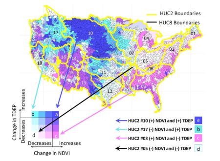
Groupings and directionality of vegetation and nitrogen deposition changes show spatial trends across the CONUS that explain instream nitrogen signals and exports. Image courtesy of Newcomer et al. (2021)

Watershed conditions around the world are changing in response to human activities. Indicators of watershed conditions can be streamflow measurements, river chemistry, and landscape characteristics, such as vegetation productivity. In-stream nitrogen (N) concentrations or exports (flow delivering N downstream) is a potential indicator of watershed conditions because of its relationship to landscape biogeochemical cycles, and is important because of the potential to exacerbate hypoxic conditions along coastal zones.

Our work provides an updated conceptual model for understanding watershed N retention conditions in response to atmospheric deposition patterns and watershed mechanisms. In particular, we utilize the wealth of publically-available continental US scale stream data from the US Geological Survey to demonstrate how watersheds can respond, recover, or transition to a new steady-state following atmospheric N-deposition.

Summary

Patterns of watershed nitrogen (N) retention and loss are shaped by how watershed biogeochemical processes retain, biogeochemically transform, and lose incoming atmospheric deposition of N. Loss patterns represented by concentration, discharge, and their associated stream exports are important indicators of integrated watershed N retention behaviors. By synthesizing changes and modalities in watershed nitrogen loss patterns based on stream data from 2200 U.S. watersheds over a 50 year record, our work revealed two patterns of watershed N-retention and loss. One was a hysteresis pattern that reflects the integrated influence of hydrology, atmospheric inputs, land-use, stream temperature, elevation, and vegetation. The other pattern was a one-way transition to a new state. We found that regions with increasing atmospheric deposition and increasing vegetation health/biomass patterns have the highest N-retention capacity, become increasingly N-saturated over time, and are associated with the strongest declines in stream N exports—a pattern that is consistent across all land cover categories. We provide a conceptual model, validated at an unprecedented scale across the CONUS that links instream nitrogen signals to upstream mechanistic landscape processes. Results of this study were published in Newcomer et al. (2021).

Citation

Newcomer, M. E., et al. (2021). Hysteresis Patterns of Watershed Nitrogen Retention and Loss over the past 50 years in United States Hydrological Basins. Global Biogeochemical Cycles. https://doi.org/10.1029/2020GB006777

Bedrock weathering contributes to subsurface reactive nitrogen and nitrous oxide emissions

This image shows an aerial view of the East River, central Colorado, United States, flowing through a mountainous watershed underlain by Cretaceous marine shale. The image was the April 2021 cover of Nature Geoscience.

Atmospheric nitrous oxide (N2O) contributes directly to global warming. Although it is known that release rates of nitrogen (N) from bedrock weathering is large, models of N2O fluxes do not consider contributions from bedrock, the largest pool of terrestrial N, as a source of N2O. In this first-of-its-kind field study, bedrock weathering is shown to contribute 78% of the subsurface reactive N, while atmospheric sources (commonly regarded as the sole sources of reactive N in pristine environments) account for the remaining 22%. About 56% of the total subsurface reactive N is denitrified by microorganisms, including 14% emitted as N2O.

Measurements-based calculations and calculations based solely on literature values both suggest that the global terrestrial N-N2O flux (10.0±2.0Tg N-N2O year−1) includes a significant and previously unrecognized contribution of about 10–20% from bedrock weathering, which needs to be accounted for as a source in predictions of global N2O fluxes and their sensitivity to climate change and disturbance.

Summary

Atmospheric nitrous oxide contributes directly to global warming, yet models of the nitrogen cycle to date have not considered bedrock, the largest pool of terrestrial nitrogen, as a source for nitrous oxide. Although it is known that release rates of nitrogen from bedrock are large, there is an incomplete understanding of the connection between bedrock-hosted nitrogen and atmospheric nitrous oxide. Here, we quantify nitrogen fluxes and mass balances along a hillslope underlain by Cretaceous marine shale. We found that, at this site, bedrock weathering contributes 78% of the subsurface reactive nitrogen, while atmospheric sources (commonly regarded as the sole sources of reactive nitrogen in pristine environments) account for only the remaining 22%. About 56% of the total subsurface reactive nitrogen is denitrified by microorganisms, including 14% emitted as nitrous oxide. The remaining reactive nitrogen discharges in porewaters to a floodplain where additional denitrification likely occurs. We also found that the release of bedrock nitrogen occurs primarily within the zone of the seasonally fluctuating water table and suggest that the accumulation of nitrate in the vadose zone, often attributed to fertilization and soil leaching, may also include contributions from weathering of nitrogen-rich bedrock. Our hillslope study suggests that, under oxygenated and moisture-rich conditions, weathering of deep, nitrogen-rich bedrock makes an important and previously unrecognized contribution to the nitrogen cycle.

Citation

Wan, J. and T.K. Tokunaga, et al. Bedrock weathering contributes to subsurface reactive nitrogen and nitrous oxide emissions, Nature Geoscience 14 (4), 217-224 (2021). https://www.nature.com/articles/s41561-021-00717-0

Modeling geogenic and atmospheric nitrogen through the East River Watershed, Colorado Rocky Mountains

Proportional breakdown of average annual sources (left pie in each panel) and sinks, or “fates” (right pie in each panel) for the entire ERW for each of the three calibration scenarios (C1-C3), two no-Mancos scenarios (NM1-NM2), and the no cow (NC) scenario.

We developed a semi-distributed, watershed-scale ensemble of models to quantify the sources, transformations, and sinks of geogenic and atmospheric nitrogen within a mountain watershed. This hydrobiogeochemical model determines nitrogen (N) export fluxes from terrestrial systems as a function of hydrology. In this way, the biogeochemical cycling of N relative to its loss through transport is determined as a continuum of subsurface water residence times. This represents a particularly novel approach to modeling nutrient cycling, one which is capable of rapidly scaling from hillslope to watershed to basin. In the current study, the model is used to predict the importance of different sources, including the weathering of N-rich shale bedrock, and sinks for N at the watershed scale. In particular, we highlight the critical role of vegetation in the retention and release of nitrogen (Maavara et al., 2021).

We developed a so-called High-Altitude Nitrogen Suite of Models (HAN-SoMo), a watershed-scale ensemble of process-based models to quantify the relative sources, transformations, and sinks of geogenic and atmospheric N through the East River watershed. This model predicts nitrogen fluxes across bedrock-to-canopy compartments, terrestrial to aquatic interfaces, and watershed-scale hydrobiogeochemical gradients as a function of subsurface water residence times through coupling to the PARFLOW model.

Summary

At the watershed scale, bedrock weathering accounted for ~21% of new N-sources (Fig. 1), which was an important albeit smaller contribution than that derived from atmospheric deposition. On an annual scale, removal of dissolved N through in stream processes (i.e., denitrification and export), plant turnover, and atmospheric deposition are the most important controls on N cycling (Maavara et al., 2021). We are currently using this model to evaluate how terrestrial N cycling pathways change under two emergent climate change scenarios: warming and wildfire. Warming significantly changes montane hydrology, including evapotranspiration, which feeds back on to subsurface water residence times and biogeochemical cycling. This model is currently being used to explore the impacts of climate warming and wildfire on downstream nitrogen exports.

Citation

Maavara T, Siirila-Woodburn ER, Maina F, Maxwell RM, Sample JE, Chadwick KD, Carroll R, Newcomer ME, Dong W, Williams KH, Steefel CI, Bouskill NJ (2021) Modeling geogenic and atmospheric nitrogen through the East River Watershed, Colorado Rocky Mountains. PLoS One. doi.org/10.1371/journal.pone.0247907

Small Landscape Features Transform Nitrogen Flowing Through Floodplains

Potential sources of water in surface depressions within a floodplain of a snowmelt-dominated catchment.

Nitrate is an important compound that influences water quality and ecosystem health. Floodplains are important landscape features directly related to water quality, since they can control how much nitrate makes it into a stream. To help clarify which features of floodplains contribute the most to controlling nitrate fluxes, researchers looked at processes that produce and consume nitrate in floodplain surface depressions. Since surface depressions accumulate water, they provide an ideal environment for microbes that consume nitrate. Researchers found that surface depressions can prevent significant amounts of nitrate from reaching the stream, and that this behavior depends on whether the water comes from rainfall, snowmelt, or stream overflow.

The processes that control how much nitrate enters streams and how much nitrate leaves a watershed are very complex. These processes range across many scales, from microbes to mountains. To help scientists determine which processes and features are most important, we quantified not only how but when floodplain surface depressions impact the amount of nitrate that passes through the floodplain. These results can be used by scientists looking to understand the processes that control nitrate dynamics in larger scale systems.

Summary

Understanding multi-scale controls on nitrogen cycling is needed to predict watershed nitrogen retention and release under climatic perturbations. This is especially important for predicting changes in water quality in mountainous headwaters, which supply water to a majority of the western U.S.
In this study, researchers used numerical simulations to quantify nitrogen cycling within floodplain surface depressions (hollows), which are potentially one of many control points for nitrogen cycling within watersheds. The authors focused on the effects of transient hydrologic and geochemical conditions, including varying surface infiltration rates and varying water compositions as determined by the source of the water. Since the study site is located within a snowmelt-dominated catchment, the authors considered infiltration due to snowmelt, rainfall, stream overflow, and groundwater upwelling. The study found that the hollows primarily remove nitrogen from the floodplain system, with rainfall being the most significant cause of this “sink” behavior. This is important considering several mountainous watersheds are showing increasing rainfall and decreasing snowfall, meaning the sink behavior of these hollows may become more amplified. The study also used loose scaling methods to show that hollows prevent a significant amount of nitrogen from reaching the stream, emphasizing their role as control points for nitrogen retention and release.

Citation

D.B. Rogers, et al., “Modeling the impact or riparian hollows on river corridor nitrogen exports.” Frontiers in Water 3, (2021). [DOI: 10.3389/frwa.2021.590314]

Do Summer Monsoons Matter for Streamflow in the Upper Colorado River?

East River, Colorado during a summer rain event. Image courtesy of Xavier Fane.

In snow-dominated western watersheds, summer monsoon rains can provide significant rainfall, but these inputs do not always translate into significant streamflow. Scientists used a hydrological model to examine how efficient monsoon rains were at producing streamflow over several decades. Results showed monsoon rains produced half the amount of streamflow compared to spring snow of the same water input. Streamflow increases from rain were limited to high elevations and strongly influenced by temperature and the previous season’s snowpack. Understanding the dynamics between snow, rain and streamflow in these western watersheds is important, particularly given a warmer future with less snow.

The study found that where rain falls within a Colorado River headwater basin strongly effects whether that rain makes it to the stream. Rain falling in the upper elevations, where water is plentiful, soils are thin and vegetation is sparse, added to streamflow. In the lower elevations, dense conifer and aspen forests consumed much of the additional water provided by the monsoon rain to limit its impact on streamflow. Summer rains produced more streamflow in cooler years and those years with a lot of snow. These complex dynamics mean that even strong summer rains cannot fully replenish water from lost snow. In a warmer future, summer rains are likely to produce less streamflow, adding to water challenges caused by decreasing snowpack.

Summary

A data-modeling framework indicates summer rains occur when atmospheric demand for water is high, soil moisture is waning, and the bulk of rain serves to moisten very dry soils and does not generate streamflow. Instead, water is quickly consumed by vegetation, with the largest increases in plant consumption of water by aspen and conifer forests. As a result, streamflow contributions from rain are half those generated by equal amounts of spring snowfall that occur when atmospheric water demand is low and soils moisture is high. Most of the rain-generated streamflow occurs at higher elevations in the watershed where soil moisture storage, forest cover, and energy demands are low. Mean elevation is the single most important predictive metric of the ability of summer rain to generate streamflow in the East River, and extrapolation estimates across the Upper Colorado River Basin indicate that streamflow generation from monsoon rains, while limited to only 5% of the region by area, can produce substantive streamflow. Interannual variability in monsoon efficiency to generate streamflow declines when snowpack is low, and aridity is high. This underscores the likelihood that the ability of monsoon rain to generate streamflow will decline in a warmer future with increased snow drought.

Citation

R.W.H. Carroll, D. Gochis, K.H. Williams, ”Efficiency of the Summer Monsoon in Generating Streamflow Within a Snow-Dominated Headwater Basin of the Colorado River”, Geophysical Research Letters, 47, (2020),[ doi: 10.1029/2020GL090856].

Groundwater Age in a Colorado River Headwater Stream

Groundwater flow paths in Copper Creek, Colorado and their ages for the (a) previously published hydrologic model, and (b) recalibrated hydrologic model using gas tracers collected in stream water at CC03. (c) Measuring stream discharge in a tributary of Copper Creek.

Older groundwater that flows through deep bedrock in mountain watersheds could be important to stream water but limited data on bedrock properties often limits our ability to examine and understand its role. To address this, the authors combined a novel stream water gas tracer experiment in a steep mountain stream in a Colorado River headwater basin (24 km2) with a previously published hydrologic model to examine relationships between streamflow age variability, shallow and deeper groundwater flows, and climate conditions. Results indicate streamflow age in the late summer varies interannually (3-12 years) as a function of shallow, subsurface flow (<1 year) that is controlled by snow dynamics. In contrast, deeper groundwater ages remain stable (12 years) across historical conditions.

Age tracer observations in streamflow provide a novel and relatively cost-effective method to indirectly characterize bedrock properties in a steep, snow-doimanted watershed that can lead to new insights into watershed functioning. The added information from the tracer data suggests more deeper groundwater flow occurs than previously thought. Collecting stream water gas data also helped identify groundwater flow path sensitivity to climate and land use change. Under wetter conditions, groundwater flow paths and ages are insensitive to climate change or forest removal. A sensitivity analysis indicates that the basin is close to a precipitation threshold. With only small shifts toward a drier state groundwater flow paths will become increasingly deeper and groundwater age in the stream increasingly older.

Summary

There is growing awareness that deep bedrock in steep, mountain watersheds could be an important part of a watershed’s hydrologic system, but the true importance of deeper groundwater flow remains largely unknown. Here the authors present a proof-of-concept for a new and efficient approach to characterize deeper groundwater flow a in mountain watershed using stream water concentrations of N2, Ar, CFC-113 and SF6. Using gas tracer observations, the authors provide solid evidence of non-trivial groundwater flow to streams that occurs at considerable depth in a mountain watershed underlain by fractured crystalline rock.

The implication for this revised conceptual model of groundwater flow in this mountain watershed is substantial. Using age tracers to inform an integrated hydrologic model, the authors move Copper Creek from a topographiclally controlled basin with hyper-localized groundwater flow paths (young ages) that are insensitive to changes in precipitation to a borderline recharge controlled groundwater basin in which groundwater flow paths are extremely sensitive to increased aridity and forest structural change. This study clarifies the importance of characterizing the bedrock groundwater system in steep mountain watersheds to predict how groundwater and surface water interactions may respond to future changes in climate, land cover or land use.

Citation

R.W.H. Carroll et al., ”Baseflow age distributions and depth of active groundwater flow in a snow-dominated mountain headwater basin”, Water Resources Research, 56, (2020),[ doi: 10.1029/2020WR028161].

Differential Concentration-Discharge (C-Q) analysis: A new approach to identifying contaminant hot spots along stream segments

A comparison of traditional C-Q patterns for nitrate across individual stations and differential C-Q approach across the upstream and downstream reaches encompassing those stations. The C-Q patterns show a consistent L-shaped pattern for nitrate across all three stations of the East River Catchment. In comparison, differential C-Q shows gains in nitrate in the upstream reach and losses in the downstream reach during high gains in discharge.

An easy-to-use C-Q approach has been developed that can account for gains, losses and/or fractional solute turnover over each stream segment. This new approach is found to yield a better accounting of the specific sources, hillslope contributions and critical stream segments that can adversely impact river water quality than traditional approaches.

The differential C- Q analysis is a valuable tool for assessing differences across stream reaches, comparing accumulation and mobilization of harmful chemicals within and across reaches, and monitoring solute behavior in the face of hydrologic and climatic perturbations. This approach can therefore aid watershed and land managers in identifying the stream segments that are essential to monitor and for designing pollution prevention/intervention strategies.

Summary

Concentration-discharge (C-Q) relationships are often used to describe how water moves through streams and the chemicals that are transported with it. These relationships are typically examined at individual sampling stations, which do not provide sufficient information about accumulation or mobilization of harmful chemicals, pesticides or other solutes. In this study, we present a new differential C-Q approach that can capture the increase, decrease, and/or the fractional solute turnover over each stream segment. To evaluate and compare this differential approach with traditionally-used approaches, water quality data collected at the East River CO watershed was used. The traditional C-Q patterns showed a consistent L-shaped pattern for nitrate across three stations of the East River watershed. In comparison, differential C-Q approach showed gains in nitrate in the upstream reach and losses in the downstream reach during high gains in discharge. In contrast to nitrate, gains in phosphate, organic carbon, molybdenum and several other solutes were observed in the downstream reach due to its low-relief, meandering terrain. In this manner, the new C-Q approach clearly indicated when and where small increases in nutrients like phosphorus and nitrate can be particularly concerning given the potential for algal growth and eutrophication. Overall, the differential C-Q approach holds potential for aiding water quality managers in the identification of critical stream reaches that assimilate harmful chemicals.

Citation

B. Arora, M. Burrus, M. Newcomer, C. I. Steefel, R. W. H. Carroll, D. Dwivedi, W. Dong, K. H. Williams, and S. S. Hubbard (2020), Differential CQ Analysis: A New Approach to Inferring Lateral Transport and Hydrologic Transients within Multiple Reaches of a Mountainous Headwater Catchment. Front. Water 2: 24, DOI: 10.3389/frwa .2020.00024

A benchmark problem for simulating kinetic isotope fractionation

Simulated and observed trends of aqueous species comparing agreement between models. Circles show observed data, while lines show simulated trends (CrunchFlow: red, Toughreact: black)

A benchmark problem set was developed for the simulation of kinetic sulfur isotope fractionation that explicitly incorporates biomass growth and tests commonly-used rate law formulations for isotope fractionation.

Benchmarking studies on isotopes are fairly limited. Modelers seeking to incorporate kinetic isotope fractionation into their codes will find in this problem set a simple benchmark to verify their codes that is based on well-established reaction rate formulations and sound mass balance principles.

Summary

Despite the availability of a large number of reactive transport codes that essentially solve the same governing equations, substantial differences exist among them. Users can differentiate codes on the basis of the capabilities they offer, and the flexibility and ease of their use. For complex subsurface settings, such as those involving multiple interacting components or requiring distinct partitioning of isotopes, the only way to verify codes and build confidence is through benchmarking activities. Here, we present a benchmark problem that involves a key process in many subsurface applications, i.e. microbially mediated sulfate reduction. This benchmark problem involves a well-characterized system where multiple aqueous species exist in tandem, Fe and S cycling are intricately coupled, and require distinct partitioning of sulfur isotopes. To ensure that the results presented in this paper were the correct solutions to the problems posed, the general-purpose reactive transport codes CrunchFlow, ToughReact, PHREEQC and PHT3D were used to perform the simulations, showing excellent agreement. Overall, this study presents a benchmark to users to assess differences (or similarities) across codes based on capabilities for kinetic isotope fractionation, biomass growth, and different rate law formulations.

Citation

Y. Cheng, B. Arora, S. S. Şengör, J. L. Druhan, C. Wanner, B. M. van Breukelen, and C. I. Steefel, “ Microbially mediated kinetic sulfur isotope fractionation: reactive transport modeling benchmark.” Comput Geosci. (2020). [DOI: 10.1007/s10596-020-09988-9]

Machine learning-based zonation for understanding snow, plant, and soil moisture dynamics within a mountain ecosystem

ML-identified zones associated with co-varied dynamics of snow, plant and soil moisture, and microtopographic features

In the headwater catchments of the Rocky Mountain region, plant dynamics are largely influenced by snow accumulation and melting as well as water availability. The key properties – snow coverage, soil moisture and plant productivity – are highly heterogeneous in mountainous terrains. This study identifies the spatiotemporal patterns in co-varied snow, plant and soil moisture dynamics associated with microtopography based on high-resolution satellite imagery and unsupervised machine learning.

The results of this study show that unsupervised leaning methods can reduce the dimensionality of time-lapse images effectively, and identify spatial regions – a group of pixels – that have similar snow-plant dynamics (based on Normalized Difference Vegetation Index) as well as their association with key topographic features as well as soil moisture. This cluster-based analysis can tractably analyze high-resolution time-lapse images to examine plant-soil-snow interactions, guide sampling and sensor placements, and identify areas likely vulnerable to ecological change in the future.

Summary

In the headwater catchments of the Rocky Mountain region, plant productivity and its dynamics are largely influenced by water availability. Understanding and quantifying the interactions between snow, plants, and soil moisture has been challenging, since these interactions are highly heterogeneous in mountainous terrain, particularly as they are influenced by microtopography within a hillslope. This study investigates the relationships among topography, snowmelt, soil moisture, and plant dynamics in the East River watershed, Crested Butte, Colorado, based on a time series of 3-meter resolution PlanetScope Normalized Difference Vegetation Index (NDVI) images. To make use of a large volume of high-resolution time-lapse images, this study uses unsupervised machine learning methods to identify the spatial zones that have characteristic NDVI time series, and to reduce the dimensionality of time lapse images into spatial zones. Results show that the identified zones are associated with snow-plant dynamics and microtopographic features. In addition, soil moisture probe and sensor data confirm that each zone has a unique soil moisture distribution. This cluster-based analysis can tractably analyze high-resolution time-lapse images to examine plant-soil-snow interactions, guide sampling and sensor placements, and identify areas likely vulnerable to ecological change in the future.

Citation

Devadoss, J., N. Falco, B. Dafflon, Y. Wu, M. Franklin, A. Hermes, E.-L. S. Hinckley, and H. Wainwright (2020), Remote Sensing-Informed Zonation for Understanding Snow, Plant and Soil Moisture Dynamics within a Mountain Ecosystem, Remote Sensing, 12(17), 2733, DOI: 10.3390/rs12172733.

Satellite-derived foresummer drought sensitivity of plant productivity in the Rocky Mountain headwater catchments

Foresummer drought sensitivity of Landsat Peak NDVI. The black lines are the boundaries of the four watersheds: Coal Creek, Slate River, Washington Gulch and East River from left to right.

Ecosystems in headwater catchments are important for water resources downstream, regulating evapotranspiration and nutrient cycling. This paper mapped where the plants are more sensitive to early summer (or foresummer) drought conditions, and also identified key controls on drought resilience such as geomorphology and geology in addition to elevation and aspect.

This study mapped the spatial heterogeneity of plants’ drought sensitivity, based on the historical Landsat images and climate data. Using machine learning methods, the authors identified key controls on drought sensitivity, related to surface energy exchanges (i.e., potential net radiation), hydrological processes (i.e., microtopography and slope), and underlying geology. This remote-sensing-based approach can be used to identify the regions that are vulnerable or resilient to climate perturbations, as well as to inform future sampling, characterization, and modeling studies.

Summary

Ecosystems in headwater catchments are important for water resources downstream, regulating evapotranspiration and nutrient cycling. Climate model ensembles predict earlier snowmelt and reduced spring precipitation in the western North America, which creates “foresummer” droughts in the primary growing season of plants. This study (1) assessed the importance of early snowmelt and foresummer drought in controlling peak plant productivity, based on the historical Landsat normalized difference vegetation index (NDVI) and climate data; (2) mapped the spatial heterogeneity of drought sensitivity over the watershed-scale; and (3) identified the environmental controls on drought sensitivity within the East Water watershed (Colorado, USA). In support of the plot-based studies, results showed that that years with earlier snowmelt and drier foresummer conditions lead to lower peak NDVI; particularly in the low-elevation regions. In addition, the foresummer drought sensitivity is spatially heterogeneous, and primarily dependent on the plant type and elevation. Using machine learning methods, we identified additional key controls related to surface energy exchanges (i.e., potential net radiation), hydrological processes (i.e., microtopography and slope), and underlying geology. This remote-sensing-based approach for quantifying foresummer drought sensitivity can be used to identify the regions that are vulnerable or resilient to climate perturbations, as well as to inform future sampling, characterization, and modeling studies.

Citation

Wainwright, H. M. et al. (2020). Satellite-derived foresummer drought sensitivity of plant productivity in Rocky Mountain headwater catchments: spatial heterogeneity and geological-geomorphological control. Accepted in Environmental Research Letters. DOI: 10.1088/1748-9326/ab8fd0