Berkeley Lab

Streamflow Partitioning and Transit Time Distribution in Snow-dominated Basins as a Function of Climate

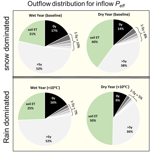
Lag of wet year (left column) and dry year (right column) inflows to exit the basin via stream discharge in the future when no temperature increase (upper row) and temperature increase =10°C (lower row).

Several models (PRMS-PEST-SAS) were coupled and applied to the snow-dominated East River Watershed to explore changes in water budgets and seasonal and annual responses in the streamflow transit time distributions.

This research was the first to apply the coupled PRMS-PEST-SAS modeling system to a large-scale (85km2) snow-dominated watershed. Results provide insight into how variation of the water budget and streamflow transit time are responding to climate change in this alpine snow-dominated system.

Summary

The modeling results show that during the snowmelt period of the year, the East River released younger water during high storage periods across seasonal and annual timescales (an “inverse storage effect”). However, wet years also appeared to increase hydrologic connectivity, which simultaneously flushed older water from the basin. During years with reduced snowpack, flow paths were inactivated and snowmelt remained in the subsurface to become older water that was potentially reactivated in subsequent wet years. Dry years were found more sensitive to warming temperatures than wet years through marked increases in the fraction of inflow lost to evapotranspiration at the expense of younger water to increase the mean age of streamflow.

Citation

Fang, Z., Carroll, R., Schumer, R., Harman, C., Wilusz, D., Williams, K., “Streamflow partitioning and transit time distribution in snow-dominated basins as a function of climate.” Journal of Hydrology. (2019) 570, 726-738. DOI: 10.1016/j.jhydrol.2019.01.029

Assessment of Spatio-temporal Variability of Evapotranspiration and Its Governing Factors in a Mountainous Watershed

Pairwise scatter plots of meteorological forcing variables, elevation and annual evapotranspiration (ET). Different colors represent ranges of leaf area index (LAI) values. Bar plots shows the variation of meteorological forcing variables, elevation and annual ET

An important process for determining the water and energy balance at the land surface is evapotranspiration. This is one of the first studies that comprehensively investigated the spatio-temporal variations of evapotranspiration in a mountainous watershed. The results showed that the spatial variability in evapotranspiration was closely corrected with the land elevation, air temperature, and vegetation, and that evapotranspiration in areas with more finely textured soil was slightly larger than regions with coarse-textured soil.

This study presents a promising approach for assessing evapotranspiration with a high spatio-temporal resolution over watershed scales and it investigates the factors controlling spatio-temporal variations in evapotranspiration.

Summary

Evapotranspiration (ET) is a key component of the water balance in a given component of the Earth system, and it influences hydrometeorology, water resources, carbon and other biogeochemical cycles, as well as ecosystem diversity. This study sought to investigate the spatio-temporal variations of ET at the East River watershed in Colorado and analyze the factors that control these variations. The simulation results showed that 55% of annual precipitation in the East River is lost to ET, in which 75% of the ET comes from the summer months (May to September). The authors also found that the contribution of transpiration to the total ET was ~50%, which is much larger than that of soil evaporation (32%) and canopy evaporation (18%). Spatial analysis indicated that the ET is greater at elevations of 2950–3200 m and lower along the river valley (3900 m). A correlation analysis of factors affecting ET showed that the land elevation, air temperature, and vegetation are closely correlated and together they govern the ET spatial variability. The results also suggested that ET in areas with more finely textured soil is slightly larger than regions with coarse-texture soil.

Citation

Tran, A.P.; Rungee, J.; Faybishenko, B.; Dafflon, B.; Hubbard, S.S. Assessment of Spatiotemporal Variability of Evapotranspiration and Its Governing Factors in a Mountainous Watershed. Water 2019, 11, 243. DOI: 10.3390/w11020243

Nitrous Oxide Emissions from Inland Waters: Are the IPCC Estimates too High?

Total N2O emissions (in 106 mol N year−1) from rivers, reservoirs and estuaries combined, for major watersheds worldwide in year 2000, for default scenario 2. Pie charts show the 10 watersheds with the greatest emissions globally, with the size of the chart representing its relative emission flux compared with the other nine watersheds shown (total magnitude of flux shown in brackets after watershed name). The pie charts show the proportion of emissions from denitrification or nitrification in reservoirs, estuaries or rivers


Nitrous oxide is a key greenhouse gas, however, emissions from inland waterways remain a major source of uncertainty in greenhouse gas budgets. The Intergovernmental Panel on Climate Change (IPCC) has proposed emission factors (EFs) of 0.25% and 0.75%, though studies have suggested that both values are either too high or too low. A new approach has been developed for estimating nitrous oxide production, denitrification, and nitrification in water bodies, and water residence time is introduced as a key control on biological activity.

The new approach to modeling nitrous oxide production concludes that the IPCC EFs are likely overestimated by up to an order of magnitude.

Summary

The authors calculated global nitrous oxide (N2O) emissions from rivers, reservoirs and estuaries within a range of 10.6–19.8 Gmol N year-1 (148–277 Gg N year-1). This is more than half, and up to an order of magnitude, lower than most studies based on IPCC’s guidelines. Despite the much-reduced N2O flux estimates, the authors found that anthropogenic perturbations to river systems have doubled to quadrupled N2O emissions from inland waters. They suggest that the IPCC emissions factors of 0.25% and 0.75% are too high to be applied across all rivers, estuaries and reservoirs, and instead they estimate the following ranges of emissions factors: 0.004%–0.005% for rivers, 0.17%–0.44% for reservoirs, and 0.11%–0.37% for estuaries.

The majority of emissions in estuaries and reservoirs originate from nitrification, while denitrification tends to dominate in rivers because of the shorter residence times. Worldwide N2O emissions from inland waters are therefore expected to rise substantially in the coming decades as a result of the ongoing global boom in dam construction, which will nearly double the number of large hydroelectric dams on Earth and increase the water residence within these water bodies.

Citation

Maavara, T., Lauerwald, R., Laruelle, G.G., Akbarzadeh, Z., Bouskill, N.J., Van Cappellen, P., Regnier, P. (2019), Nitrous oxide emissions from inland waters: Are IPCC estimates too high?, Global Change Biology, doi: 10.1111/gcb.14504

Replicating subsurface processes in the laboratory

2.0 m tall laboratory sediment column and example measurements. a. instrument distribution, b. column clad with heat exchangers, c. column with insulation sleeve, d. seasonal field temperature profiles replicated in column, e. seasonal CO2 profiles from laboratory column.

Fluid flows with temperatures that are not constant are known as non-isothermal. Although changing thermal and hydrological conditions control rates of sediment biogeochemical processes in the Earth’s subsurface, these conditions are difficult to simulate in the laboratory. In this study, a novel 2 m tall column system to control time- and depth-dependent temperature profiles and water saturation was developed, which is needed to more accurately reproduce subsurface processes in the laboratory.

Temperature and moisture profiles in sediments are highly variable, and control biogeochemical processes, yet have not previously been reproduced in the laboratory. This study established field temperature and moisture profiles in a laboratory column system, and showed the importance of microbial respiration below the plant root zone by measuring CO2 production within the sediment column.

Summary

Transport between the soil surface and groundwater is commonly mediated through deeper portions of variably saturated sediments and the capillary fringe, where variations in temperature and water saturation strongly influence biogeochemical processes. Temperature control is particularly important because room temperature is not representative of most soil and sediment environments. The authors described and tested a novel sediment column design that allows laboratory simulation of thermal and hydrologic conditions found in many field settings. The 2.0 m tall column was capable of replicating temperatures varying from 3 to 22 ˚C, encompassing the full range of seasonal temperature variation observed in the deep, variably saturated sediments and capillary fringe of a semi-arid floodplain in western Colorado, United States. The water table was varied within the lower 0.8 m section of the column, while profiles of water content and matric (capillary) pressure were measured. CO2 collected from depth-distributed gas samplers under representative seasonal conditions reflected the influences of temperature and water-table depth on microbial respiration. Thus, realistic subsurface biogeochemical dynamics can be simulated in the laboratory through establishing column profiles that more accurately represent seasonal thermal and hydrologic conditions.

Citation

Tokunaga, T.K., Y. Kim, J. Wan, M. Bill, M. Conrad, and W. Dong, “Method for Controlling Temperature Profiles and Water Table Depths in Laboratory Sediment Columns. Vadose Zone Journal 17,180085 (2018). [DOI: 10.2136/vzj2018.04.0085]

Sustainable Remediation of Complex Environmental Systems: Key Recent Technical Advances

Simulated uranium plume (concentration>1×10⁻⁶mol/L) in 3D at the Savannah River Site F-Area in 2050. The sky-blue region is the low permeable Tan Clay Zone, which separates the upper and lower aquifers.

This book chapter provides an overview of the key recent scientific advances to support sustainable remediation in complex geological systems demonstrated at the Savannah River Site F-Area, including site characterization techniques, hydrological and geochemical model developments and numerical simulations.

We have developed various subsurface characterization and modeling technologies to improve the predictive understanding of the groundwater contaminant plumes in complex geological systems. The technologies have been demonstrated at the Department of Energy’s Savannah River Site.

Summary

Groundwater remediation has been evolved recently with increased focus on sustainable approaches such as in situ treatments and natural attenuation. However, leaving contaminants in subsurface requires the increased burden of proof to show that plumes are stable and residual contaminants do not pose a significant health risk. At the Department of Energy’s Savannah River Site, we have developed and demonstrated various characterization and modeling technologies to provide the predictive understanding of the contaminant plume migration, including (1) a multiscale data integration method to integrate surface seismic and borehole datasets that have different resolution and spatial coverage, (2) a novel surface complexation model to describe pH-dependent uranium sorption behavior based on readily available datasets, and (3) a reactive transport modeling and uncertainty quantification framework to predict the future uranium plume behavior and to identify key parameters on the future uranium concentration. These technologies are expected to transform groundwater remediation at many other sites.

Citation

Wainwright, H. M.; Arora, B.; Faybishenko, B.; Molins, S.; Hubbard, S. S.; Lipnikov, K.; Moulton, D.; Flach, G.; Eddy-Dilek, C.; Denham, M. (2018), Sustainable Remediation in Complex Geologic Systems, The heaviest metals: Science and technology in Actinides and beyond.

Geochemical Exports to River from the Intra-Meander Hyporheic Zone under Transient Hydrologic Conditions at East River

Figure 1: Spatial distributions of dissolved geochemical species in groundwater in the meander C.

Hyporheic exchange within the intra-meander region results in the interaction of nutrient-rich groundwater and oxygen-rich river water, which leads to the formation of distinct redox gradients. These redox gradients can significantly impact the export of metals and nutrients at the local, reach, and watershed scales. Further, transient hydrologic conditions, such as groundwater flow dynamics, river-stage fluctuations, and rainfall/snowmelt events, can impact redox processes in the hyporheic zone and ultimately the geochemical exports to the river thereby affecting river water quality. Here we have used high-resolution hydrodynamic assessments of the hyporheic zone combined with detailed pore-water sampling to focus on the hyporheic exchange at the meander scale for the purpose of quantifying the subsurface exports from a single meander to the river under transient hydrological conditions.

This study is a first of its kind that examines the influence of transient hydrological conditions on the hyporheic biogeochemistry using field observations. Simulation results demonstrated that intra-meander hyporheic zones display distinct anoxic and suboxic regions, suboxic regions being localized along sides of the meander bend. Permeability within the meander has a more significant impact on biogeochemical zonation compared to the reaction pathways for transient hydrologic conditions. Here we have also demonstrated the outsized implications of micro-topographic features such as gullies on redox processes using the high-resolution LiDar data.

Figure 2. Net cumulative geochemical export of TIC, DOC, and iron(II) from a single meander. River-stage is shown in green on the right y-axis, whereas the net export is shown in golden color on the left y-axis.

Summary

Hyporheic zones perform important ecological functions by linking terrestrial and aquatic systems within watersheds. Hyporheic zones can act as a source or sink for various metals and nutrients. Transient hydrologic conditions alter redox conditions within an intra-meander hyporheic zone thus affecting the behavior of redox-sensitive species. Here we investigated how transient hydrological conditions control the lateral redox zonation within an intra-meander region of the East River and examined the contribution of a single meander on subsurface exports of carbon, iron, and other geochemical species to the river. The simulation results demonstrated that the reductive potential of the lateral redox zonation was controlled by groundwater velocities resulting from river-stage fluctuations, with low-water conditions promoting reducing conditions. The sensitivity analysis results showed that permeability had a more significant impact on biogeochemical zonation compared to the reaction pathways under transient hydrologic conditions. The simulation results further indicated that the meander acted as a sink for organic and inorganic carbon as well as iron during the extended baseflow and high-water conditions; however, these geochemical species were released into the river during the falling limb of the hydrograph. This study demonstrates the importance of including hydrologic transients, using a modern reactive transport approach, to quantify exports within the intra-meander hyporheic zone at the riverine scale.

Citation

Dwivedi, D., C.I. Steefel, B. Arora, M. Newcomer, J.D. Moulton, B. Dafflon, B. Faybishenko, P. Fox, P. Nico, N. Spycher, R. Carroll, and K.H. Williams (2018), Geochemical Exports to River from the Intra-Meander Hyporheic Zone under Transient Hydrologic Conditions: East River Mountainous Watershed, Colorado, Water Resources Research, 10.1029/2018WR023377.

Using strontium isotopes to evaluate how local topography affects groundwater recharge

Figure 1. 87Sr/86Sr vs 1/[Sr] showing the mixing relationships between vadose zone porewater and groundwater. Blue line shows the mixing model of vadose zone water with upgradient groundwater with bold numbers representing the percentage of vadose zone water in the local aquifer.

A key component of understanding the connection between groundwater quality and the vadose zone (the water unsaturated region above the water table) is the movement of water from the surface to the aquifer (recharge). Measurements of the natural isotopic composition of Sr were used to assess the effect of local topography on groundwater recharge across a semi-dry riparian floodplain in the Upper Colorado River Basin.

This work demonstrates the use of 87Sr/86Sr (Sr isotopes) to measure groundwater recharge through analysis of porewater and groundwater samples from the vadose zone. The study resulted in an understanding how the microtopography of the Rifle Site affects the hyper-local variation in the downward movement of vadose-zone porewater that may carry nutrients and contaminants to groundwater.

Figure 2. “Heat” map of the percentage contribution of vadose water to the Rifle floodplain aquifer based on the Sr isotopic mixing model.

Summary

Over time, loose sand, clay, silt, gravel or similar unconsolidated, or “alluvial” material is deposited by water into alluvial aquifers. Recharge of alluvial aquifers is a key component in understanding the interaction between floodplain vadose zone biogeochemistry and groundwater quality. The Rifle Site (a former U-mill tailings site) adjacent to the Colorado River is a well-established field laboratory that has been used for over a decade for the study of biogeochemical processes in the vadose zone and aquifer. This site is exemplary of both a riparian floodplain in a semiarid region and a post-remediation U-tailings site. The authors use Sr isotopic data for groundwater and vadose zone porewater samples to build a mixing model for the fractional contribution of vadose zone porewater (i.e. recharge) to the aquifer and to assess its distribution across the site. The vadose zone porewater contribution to the aquifer ranged systematically from 0% to 38% and appears to be controlled largely by the microtopography of the site. The area-weighted average contribution across the site was 8%, corresponding to a net recharge of 7.5 cm. Given a groundwater transport time across the site of ~1.5 to 3 years, this translates to a recharge rate between 5 and 2.5 cm/yr, and with the average precipitation to the site, implies a loss from the vadose zone due to evapotranspiration of 83% to 92%.

Citation

Christensen, J. N., et al. (2018), Using strontium isotopes to evaluate the spatial variation of groundwater recharge, Sci Total Environ, 637-638, 672-685, DOI: 10.1016/j.scitotenv.2018.05.019.

Unexpected High Carbon Fluxes from the Deep Unsaturated Zone in a Semi-Arid Region

Figure: Estimated carbon fluxes and balance along the measurement transect, showing 30% of annual CO2 emissions from deeper than 1.0 m, contrary to predictions of < 1% by the Earth System Models.

Understanding of terrestrial carbon cycling has relied primarily on studies of top soils that are typically characterized to depths shallower than 0.5 m. We found and quantified 30% of CO2 annual efflux to atmosphere (60% in winter) originates from below 1 m, contrary to prediction of <1% by the ESM land models.

We contend that ESM land models need to incorporate these deeper soil processes to improve CO2 flux predictions in semi-arid climate regions.

Summary

Understanding of terrestrial carbon cycling has relied primarily on studies of topsoils that are typically characterized to depths shallower than 0.5 m. At a semi-arid site, instrumented down to 7 meters, we measured seasonal- and depth-resolved carbon inventories and fluxes, and groundwater and unsaturated zone flow rates. We identified an unexpected high dissolved organic carbon (DOC) flux from the rhizosphere into the underlying unsaturated zone. We measured that ~30% of the CO2 efflux to atmosphere (60% in winter) originates from below 1 m, contrary to prediction of <1% by Earth System Model land models. The seasonal DOC influx and favorable temperatures, moisture and oxygen availability in deeper unsaturated zone sustained the respirations of deeper microbial communities and roots. These conditions are common characteristics of many subsurface environments; thus we contend that ESM land models need to incorporate these deeper soil processes to improve CO2 flux predictions in semi-arid climate regions.

Citation

Wan, J., Tokunaga, T.K., Dong, W., Williams, K.H., Kim, Y., Conrad, M.E., Bill, M., Riley, W.J., Susan S.H., Deep unsaturated zone contributions to carbon cycling in semiarid environments. Journal of Geophysical Research: Biogeosciences, 123. https://doi.org/10.1029/2018JG004669.

Factors Controlling Seasonal Groundwater and Solute Flux from Snow-Dominated Basins

Fig. 1: Mixing diagram in U-space with Pumphouse stream discharge plotted in rainbow. Seasonal end-member means are connected with grey connecting lines while end-member variability (black error bars) determined using ±1sd of observed tracer concentrations.

Research identifies critical zone influences on hydrologic partitioning and tracer variability as reflected in seasonal stream concentration-discharge (C-Q) relationships. The method is applied across scale and within topographically complex, snow-dominated basins. First-order controls on seasonal streamflow generation are isolated and hydro-chemical conceptual model development is initiated.

The role of groundwater contribution to snow-dominated, low-order streams residing in basins of large relief is found significant; with recharge increasing in the upper sub-alpine where maximum snow accumulation is coincident with reduced conifer cover and lower canopy densities. Error in estimated stream concentrations is attributed to differences in water partitioning, source rock, seasonal shifts in flow path and sulfate reduction in floodplain sediments.

Fig. 2: Topographic and vegetation controls on snow water equivalent (SWE) and fraction of streamflow that is groundwater (fGW).

Summary

To isolate first-order controls on seasonal streamflow generation within highly heterogeneous, snow-dominated basins of the Colorado River, authors developed a multivariate statistical approach of end-member mixing analysis (EMMA) using a suite of daily chemical and isotopic observations. Mixing models are developed across 11 nested basins (0.4 km2 to 85 km2) spanning a gradient of climatological, physical and geological characteristics. Hydrograph separation using rain, snow and groundwater as end-members indicates that seasonal contributions of groundwater to streams is significant. Mean annual groundwater flux ranges from 12% to 33% while maximum groundwater contributions of 17% to 50% occur during baseflow. Groundwater recharge is found to increase in basins of high relief and within the upper sub-alpine where maximum snow accumulation is coincident with reduced conifer cover and lower canopy densities (Fig. 1). The mixing model developed for the furthest downstream site did not transfer to upstream basins. The resulting error in predicted stream concentrations points toward weathering reactions as a function of source rock and seasonal shifts in flow path. Additionally, the potential for microbial sulfate reduction in floodplain sediments along a low gradient, meandering portion of the river is sufficient to modify hillslope contributions and alter mixing ratios in the analysis. Soil flushing in response to snowmelt is not included as an end-member but is identified as an important mechanism for release of solutes from these mountainous watersheds.

Citation

R. W. H. Carroll, L. A. Bearup, W. Brown, W. Dong, M. Bill, and K. H. Williams, “Factors Controlling Seasonal Groundwater and Solute Flux from Snow-Dominated Basins.” Hydrological Processes, Special Issue: Water in the Critical Zone 32 (14), 2187-2202 (2018). [https://doi.org/10.1002/hyp.13151].

An early warning system for tracking groundwater contamination

Figure 1. Kalman-filter based in situ real-time monitoring system

A real-time, in-situ, ‘smart’ monitoring and early warning system for migrating and reacting contaminant plumes was developed using a Kalman filter-based framework and successfully tested at the contaminated Savannah River Site.

Figure 2. System validation using historical, cheap proxy variables (specific conductance and pH) to estimate U-238


As this framework enables easy integration of networked, autonomous and inexpensive wellbore measurements with cloud computing, the approach is expected to reduce groundwater monitoring cost, increase confidence in the efficacy of monitored natural attenuation, and ensure early response if needed.

Summary
  • A Kalman filter method was used to estimate contaminant concentrations continuously and in real-time by coupling data-driven concentration decay models with data correlations.
  • The approach was successfully demonstrated using historical groundwater data from the Uranium and Tritium-contaminated Savannah River Site F-Area
  • Specific conductance and pH were used as proxy variables to estimate tritium and uranium concentrations over time.
  • Results show that the developed method can estimate contaminant concentrations based on in-situ, easily measured variables
Citation

Schmidt, F., Wainwright, H. M., Faybishenko, B., Denham, M., & Eddy-Dilek, C. (2018). In Situ Monitoring of Groundwater Contamination Using the Kalman Filter. Environmental Science & Technology, DOI: 10.1021/acs.est.8b00017.