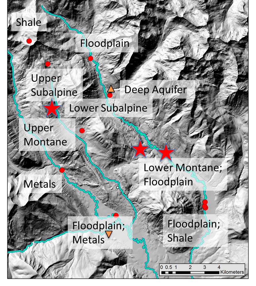
The East River Watershed Function SFA study site will provide a collaborative platform for the scientific community. Below is a concise representation of where our intensive/satellite sites are located, and key measurements that are being taken at each. An interactive version of this map with further details is being developed, but for now, if you are a prospective collaborator and have further questions, please reach out to Eoin Brodie (elbrodie@lbl.gov).
Site Data: Our Community Watershed Interactive Portal identifies sites where the SFA team and collaborators are acquiring different types of measurements within the watershed. Prospective collaborators or investigators with questions are encouraged to reach out to Eoin Brodie.
Current project contributors and collaborators, please reference our data policy and see the other data links in the menu bar above.
![]()
Intensive site: used by all teams to address all questions of the Watershed Function SFA
![]()
Satellite site: used by select teams to address select questions of the Watershed Function SFA
![]()
Location of RMBL (Rocky Mountain Biological Laboratory)
![]()
Location of Crested Butte, CO
Site images
Click here for field camera images of the site (updated daily).
Site Description
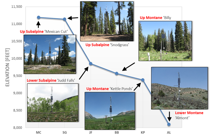
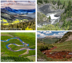
The East River Watershed SFA site encompasses the drainages of the East River, Washington Gulch, Slate River, and Coal Creek. The watershed is located northeast of the town of Crested Butte, CO and covers an area of ca. 300 km2 at an average elevation of 3266 m. Over the watershed’s 1420 m of topographic relief, pronounced gradients exist in hydrology, geomorphology, biome type or life zone (montane, subalpine, alpine), and extent of impact by historic mining activities and naturally mineralized rock, with Slate River and Coal Creek more heavily impacted by heavy metals, such as arsenic, copper, cadmium, and zinc, than either the East River or Washington Gulch. The watershed has a mean annual temperature of ~0 oC, with average minimum and maximum temperatures of -9.2 oC and 9.8 oC, respectively. The watershed receives ca. 600 mm of precipitation per year, the bulk of which falls as snow, and is representative of many other headwaters systems within the upper Colorado River Basin. The East River is one of two major tributaries that form the Gunnison River, which in turn accounts for just under half of the Colorado River’s discharge at the Colorado/Utah border.
More information about the East River Watershed SFA site is provided here.
Safety
Collaborators should—and LBNL employees must—familiarize themselves with the hazards of working at East River. Please see here or contact Ken Williams for more details.
SFA Watershed Infrastructure Boot Up
As of May 2016
- 8 weather stations
- 2 NOAA SNOTEL stations
- DEM and airborne snow survey
- EPA CASTNET station
- 19 stream gage stations
- 32 alluvial piezometers
- 3 deep groundwater wells
- 15 stream sampling locations (daily, weekly)
- Water quality sondes (pH, ORP, EC, DO, fDOM, turbidity); 5-min data
- Continuous d2H, d18O-H2O
- 96 metagenomic samples