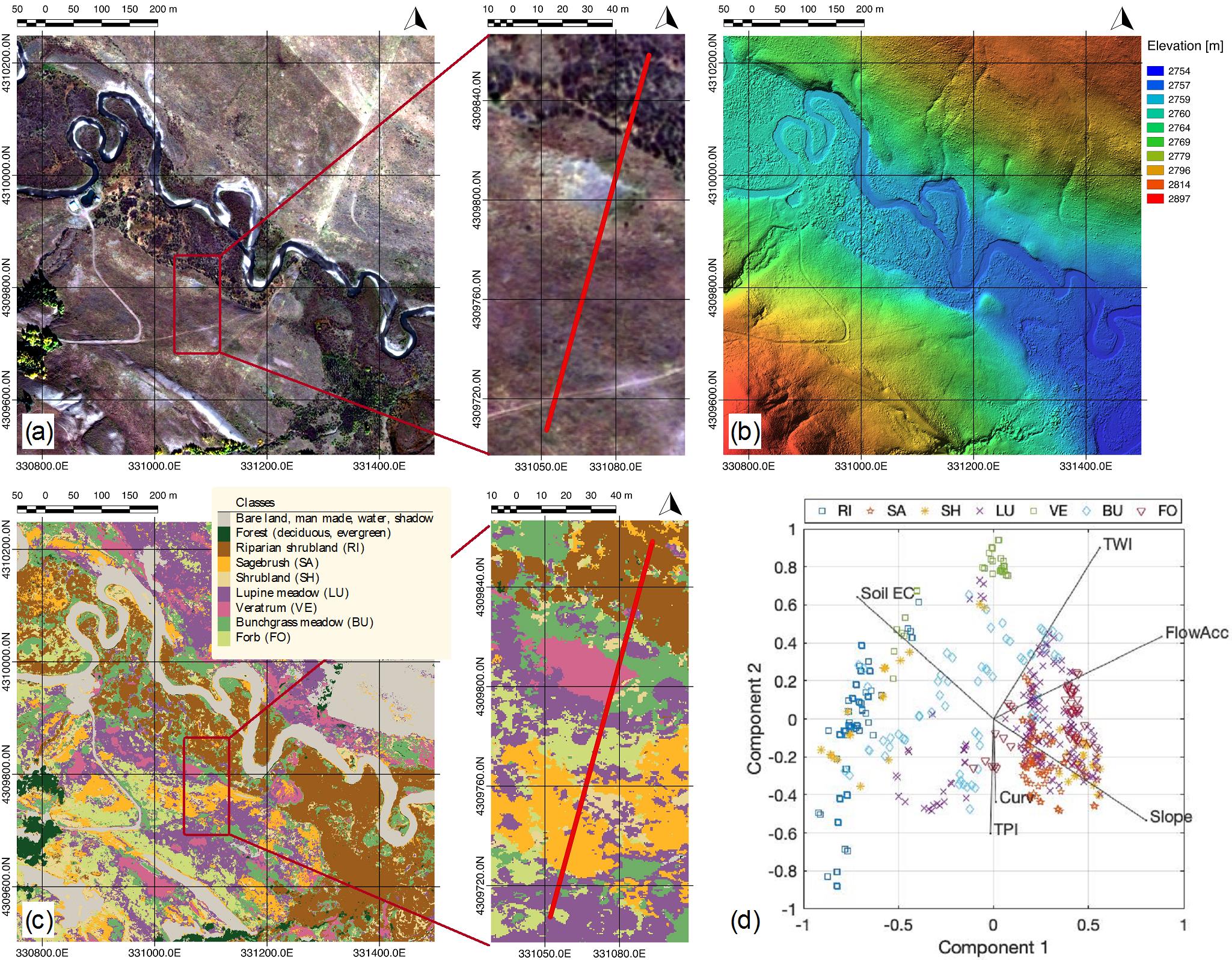
(a) View of the hillslope-floodplain area study acquired by Worldview-2 satellite, including the ERT transect (in red color); (b) Digital terrain model capturing the microtopography; (c) Map of the spatial distribution of plant communities at sub-meter resolution; (d) Biplot based on principal component analysis that shows the co-variability between plant community, soil electrical conductivity, and topographical metrics. Legend: riparian shrubland (RI), sagebrush (SA), shrubland (SH), lupine meadow (LU), veratrum (VE), bunchgrass meadow (BU), and forb (FO).
Integration of high-resolution remote sensing and geophysical data for the investigation of the co-variability between plant community distributions, soil electrical conductivity, and microtopographical properties was used to assess the spatial organization of meadow plants within a floodplain-hillslope system at the East River watershed in Colorado.
This study fused satellite and Light Detection and Ranging (LiDAR) data, along with site characterization data to arrive at estimates of key meadow communities at high resolution. This type of information could be used on large scales to provide information on the spatial variability of soil properties, and it could also be used to capture plant community responses to perturbations over significant landscape areas.
Summary
In this study, the authors aimed to understand how soil and topographic properties influence the spatial distribution of plant communities within a floodplain-hillslope system, located in the mountainous East River watershed in Colorado. Watersheds are vulnerable to environmental change, including earlier snowmelt, changes in precipitation, and temperature trends, all of which can alter plant communities and associated water and nutrient cycles within the watershed. However, tractable yet accurate quantification of plant communities is challenging to do at a scale that also permits investigations of the key controls on their distribution. In this work, the team developed a framework that uses a new approach to estimate plant distributions, one which exploits both remote sensing (satellite) images and surface geophysical data. Joint consideration of the above-and-belowground datasets allowed the team to characterize both plant and soil properties at high spatial resolution and to identify the main environmental controls for plant distribution. The results show that soil moisture and microtopography strongly influence how plant communities are spatially distributed. Considering that each community responds to external perturbation in a different way, this method can be used within a multi-temporal framework to characterize environmental heterogeneity and to capture plant responses caused by climate-related perturbations.
Citation
N. Falco, H. M. Wainwright, B. Dafflon, E. Léger, J. Peterson, H. Steltzer, C. Wilmer, J. C. Rowland, K. H. Williams, and S. S. Hubbard, “Investigating Microtopographic and Soil Controls on a Mountainous Meadow Plant Community Using High – Resolution Remote Sensing and Surface Geophysical Data.” Journal of Geophysical Research: Biogeosciences, (2019). DOI: 10.1029/2018JG004394
