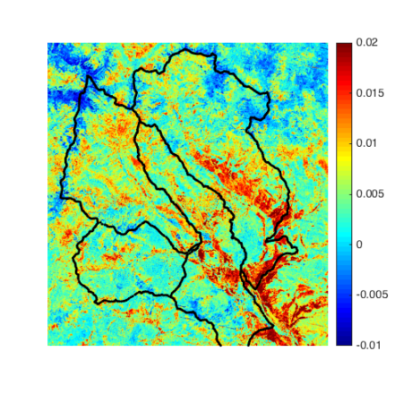
Foresummer drought sensitivity of Landsat Peak NDVI. The black lines are the boundaries of the four watersheds: Coal Creek, Slate River, Washington Gulch and East River from left to right.
Ecosystems in headwater catchments are important for water resources downstream, regulating evapotranspiration and nutrient cycling. This paper mapped where the plants are more sensitive to early summer (or foresummer) drought conditions, and also identified key controls on drought resilience such as geomorphology and geology in addition to elevation and aspect.
This study mapped the spatial heterogeneity of plants’ drought sensitivity, based on the historical Landsat images and climate data. Using machine learning methods, the authors identified key controls on drought sensitivity, related to surface energy exchanges (i.e., potential net radiation), hydrological processes (i.e., microtopography and slope), and underlying geology. This remote-sensing-based approach can be used to identify the regions that are vulnerable or resilient to climate perturbations, as well as to inform future sampling, characterization, and modeling studies.
Summary
Ecosystems in headwater catchments are important for water resources downstream, regulating evapotranspiration and nutrient cycling. Climate model ensembles predict earlier snowmelt and reduced spring precipitation in the western North America, which creates “foresummer” droughts in the primary growing season of plants. This study (1) assessed the importance of early snowmelt and foresummer drought in controlling peak plant productivity, based on the historical Landsat normalized difference vegetation index (NDVI) and climate data; (2) mapped the spatial heterogeneity of drought sensitivity over the watershed-scale; and (3) identified the environmental controls on drought sensitivity within the East Water watershed (Colorado, USA). In support of the plot-based studies, results showed that that years with earlier snowmelt and drier foresummer conditions lead to lower peak NDVI; particularly in the low-elevation regions. In addition, the foresummer drought sensitivity is spatially heterogeneous, and primarily dependent on the plant type and elevation. Using machine learning methods, we identified additional key controls related to surface energy exchanges (i.e., potential net radiation), hydrological processes (i.e., microtopography and slope), and underlying geology. This remote-sensing-based approach for quantifying foresummer drought sensitivity can be used to identify the regions that are vulnerable or resilient to climate perturbations, as well as to inform future sampling, characterization, and modeling studies.
Citation
Wainwright, H. M. et al. (2020). Satellite-derived foresummer drought sensitivity of plant productivity in Rocky Mountain headwater catchments: spatial heterogeneity and geological-geomorphological control. Accepted in Environmental Research Letters. DOI: 10.1088/1748-9326/ab8fd0
