ML-identified zones associated with co-varied dynamics of snow, plant and soil moisture, and microtopographic features
In the headwater catchments of the Rocky Mountain region, plant dynamics are largely influenced by snow accumulation and melting as well as water availability. The key properties – snow coverage, soil moisture and plant productivity – are highly heterogeneous in mountainous terrains. This study identifies the spatiotemporal patterns in co-varied snow, plant and soil moisture dynamics associated with microtopography based on high-resolution satellite imagery and unsupervised machine learning.
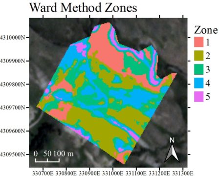
The results of this study show that unsupervised leaning methods can reduce the dimensionality of time-lapse images effectively, and identify spatial regions – a group of pixels – that have similar snow-plant dynamics (based on Normalized Difference Vegetation Index) as well as their association with key topographic features as well as soil moisture. This cluster-based analysis can tractably analyze high-resolution time-lapse images to examine plant-soil-snow interactions, guide sampling and sensor placements, and identify areas likely vulnerable to ecological change in the future.
Summary
In the headwater catchments of the Rocky Mountain region, plant productivity and its dynamics are largely influenced by water availability. Understanding and quantifying the interactions between snow, plants, and soil moisture has been challenging, since these interactions are highly heterogeneous in mountainous terrain, particularly as they are influenced by microtopography within a hillslope. This study investigates the relationships among topography, snowmelt, soil moisture, and plant dynamics in the East River watershed, Crested Butte, Colorado, based on a time series of 3-meter resolution PlanetScope Normalized Difference Vegetation Index (NDVI) images. To make use of a large volume of high-resolution time-lapse images, this study uses unsupervised machine learning methods to identify the spatial zones that have characteristic NDVI time series, and to reduce the dimensionality of time lapse images into spatial zones. Results show that the identified zones are associated with snow-plant dynamics and microtopographic features. In addition, soil moisture probe and sensor data confirm that each zone has a unique soil moisture distribution. This cluster-based analysis can tractably analyze high-resolution time-lapse images to examine plant-soil-snow interactions, guide sampling and sensor placements, and identify areas likely vulnerable to ecological change in the future.
Citation
Devadoss, J., N. Falco, B. Dafflon, Y. Wu, M. Franklin, A. Hermes, E.-L. S. Hinckley, and H. Wainwright (2020), Remote Sensing-Informed Zonation for Understanding Snow, Plant and Soil Moisture Dynamics within a Mountain Ecosystem, Remote Sensing, 12(17), 2733, DOI: 10.3390/rs12172733.
