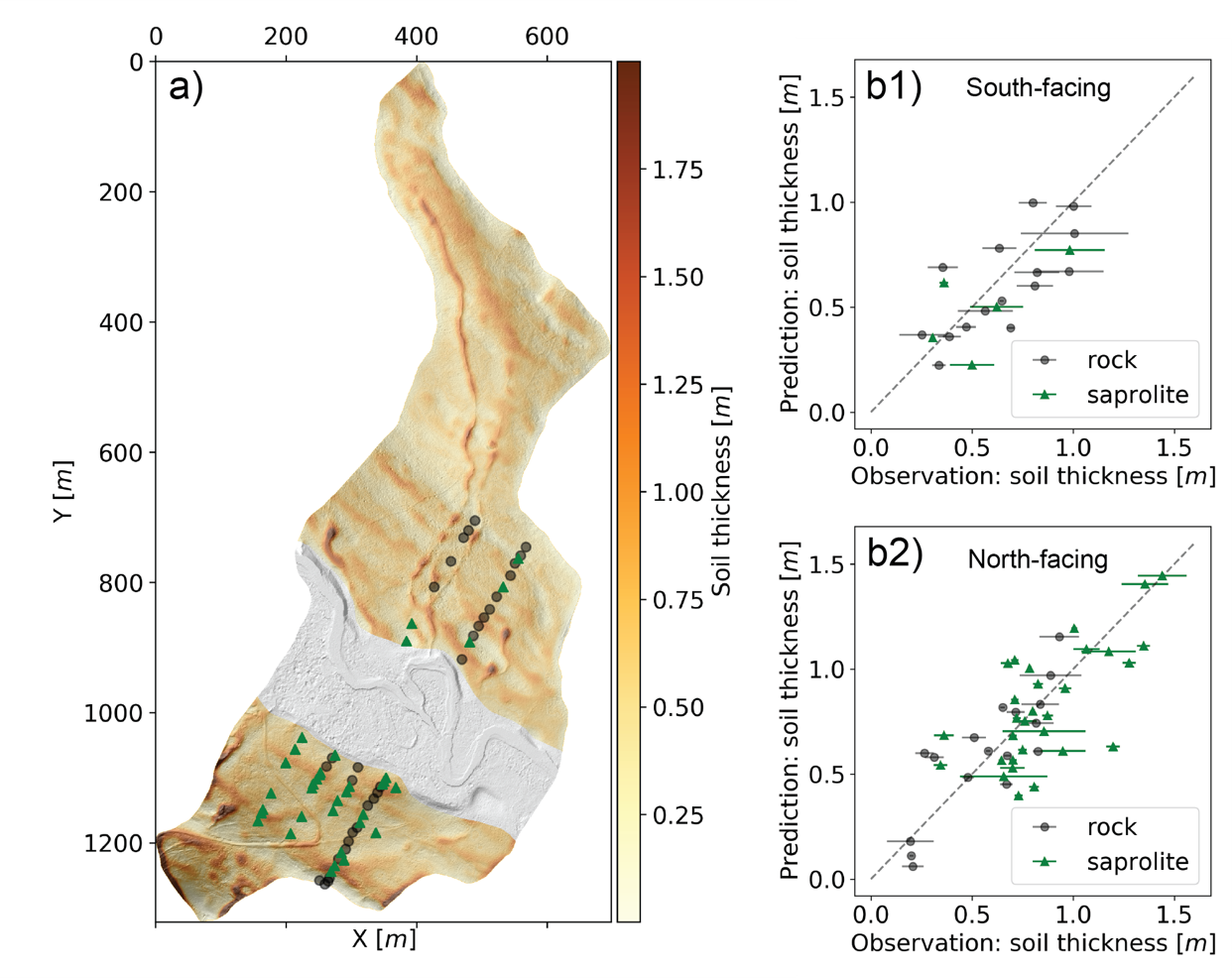
Soil thickness map. (a) The map of soil thickness from modeling. (b1) and (b2) Comparison between model and field measurements for the south-facing and north-facing hillslope, respectively. The error bars along the x-axis are the differences between auger and CPT data. Gray and green dots present the bottom of the sampling site is bedrock and saprolite, respectively.
The Science
Soil thickness plays a central role in the interactions between vegetation, soils, and topography where it controls the retention and release of water, carbon, nitrogen, and metals. However, mapping soil thickness—here defined as the mobile regolith layer—at high spatial resolution remains challenging. An accurate soil thickness map can improve the estimation of water, carbon, nitrogen, and other elements dynamics for hydrologic and biogeochemical modelling, but soil thickness remains one of the key uncertainties because of the complexity of factors that affect soil thickness.
The Impact
A new hybrid model combines a process-based model with empirical relationships to reveal the fundamental mechanisms of soil thickness and understand the spatial variability. This hybrid model generalizes the mechanisms and is therefore applicable to various sites. The soil thickness map can be an essential input for Earth System model, particularly for land surface models.
Summary
Here, the authors develop a hybrid model that combines a process-based model and empirical relationships to estimate the spatial heterogeneity of soil thickness with fine spatial resolution (0.5 m). The authors apply this model to two aspects of hillslopes (southwest- and northeast-facing, respectively) in the East River Watershed in Colorado. Two independent measurement methods—auger and cone penetrometer—are used to sample soil thickness at 78 locations to calibrate the local value of unconstrained parameters within the hybrid model. Sensitivity analysis using the hybrid model reveals that the diffusion coefficient used in hillslope diffusion modelling has the largest sensitivity among all input parameters. In addition, our results from both sampling and modeling show that, in general, the northeast-facing hillslope has a deeper soil layer than the southwest-facing hillslope. By comparing the soil thickness estimated between a machine learning approach and this hybrid model, the hybrid model provides higher accuracy and requires less sampling data. Modeling results further reveal that the southwest-facing hillslope has a slightly faster surface soil erosion rate and soil production rate than the northeast-facing hillslope, which suggests that the relatively less dense vegetation cover and drier surface soils on the southwest-facing slopes influence soil properties. With seven parameters in total for calibration, this hybrid model can provide a realistic soil thickness map with a relatively small amount of sampling dataset comparing to machine learning approach. Integrating process-based modeling and statistical analysis not only provides a thorough understanding of the fundamental mechanisms for soil thickness prediction, but integrates the strengths of both statistical approaches and process-based modeling approaches.
Citation
Yan, Q., Wainwright, H., Dafflon, B., Uhlemann, S., Steefel, C. I., Falco, N., Kwang, J., and Hubbard, S. S.: A hybrid data–model approach to map soil thickness in mountain hillslopes, Earth Surf. Dynam., 9, 1347–1361, https://doi.org/10.5194/esurf-9-1347-2021, 2021
