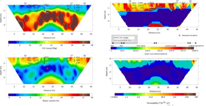
2D Estimates of cation exchange capacity, water content, grain size and permeability were obtained along a 45m ecosystem transect through development and demonstration of a field geophysical method called spectral induced polarization tomography. Image courtesy of the authors (A. Revil et al.)
The Science
Properties that influence how fluids flow and react in soils are difficult to measure using conventional techniques. This challenge stems from the time and cost involved to collect and analyze soil samples, and because collection of the soil samples can disturb the property of interest. This study describes how a surface geophysical approach, called spectral induced polarization tomography, can be used to estimate soil chemical and physical processes over field scales without disturbing the soil. The authors demonstrated the geophysical approach by collecting data along an ecosystem transect. Analysis of the data led to high-resolution estimates of important soil properties over the top 4 meters of soil along the transect, including cation exchange capacity, water content, grain size and permeability. Comparison of the obtained estimates with lab and soil core measurements indicated good agreement.
The Impact
This is the first ever field-scale estimation of soil hydrogeochemical properties using a geophysical approach called spectral induced polarization tomography. The ability to remotely quantify soil hydrological and geochemical properties in high resolution and over field-relevant scales, as demonstrated by this study, is expected to be useful for many applications, including watershed and ecosystem investigations, geotechnical engineering, and agriculture.
Summary
Estimates of soil properties such as Cation Exchange Capacity (CEC), water content, grain size and permeability are important in geotechnical engineering, water resources, and agriculture. We develop a non-intrusive approach to estimate these properties in the field using spectral induced polarization (SIP) tomography. This geophysical method provides information about the frequency dependence of the complex electrical conductivity of porous media. Using 18 soil samples collected from a managed ecosystem, we first conducted a laboratory study using SIP over the frequency range 10 mHz-45 kHz. The laboratory data were used to confirm the accuracy of a recently developed dynamic Stern layer petrophysical model. A comparison was made by comparing the field complex conductivity spectra and the experimental data at two locations where core samples were obtained. The model was then used in concert with field data to image the spatial distribution of CEC, water content, permeability, and mean grain size along a 2D transect. For clay and sandy textures found in the field, good agreement was found between measured and estimated CEC values. Our approach provides an efficient way to estimate important soil properties in a non-invasive manner, in high resolution, and over field-relevant scales of the critical zone of the Earth.
Citation
Revil, A., Schmutz, M., Abdulsamad, F., Balde, A., Beck, C., Ghorbani, A., Hubbard, S.S. (2021). Field-scale estimation of soil properties from spectral induced polarization tomography. Accepted in Geoderma. DOI: 10.1016/j.geoderma.2021.115380
