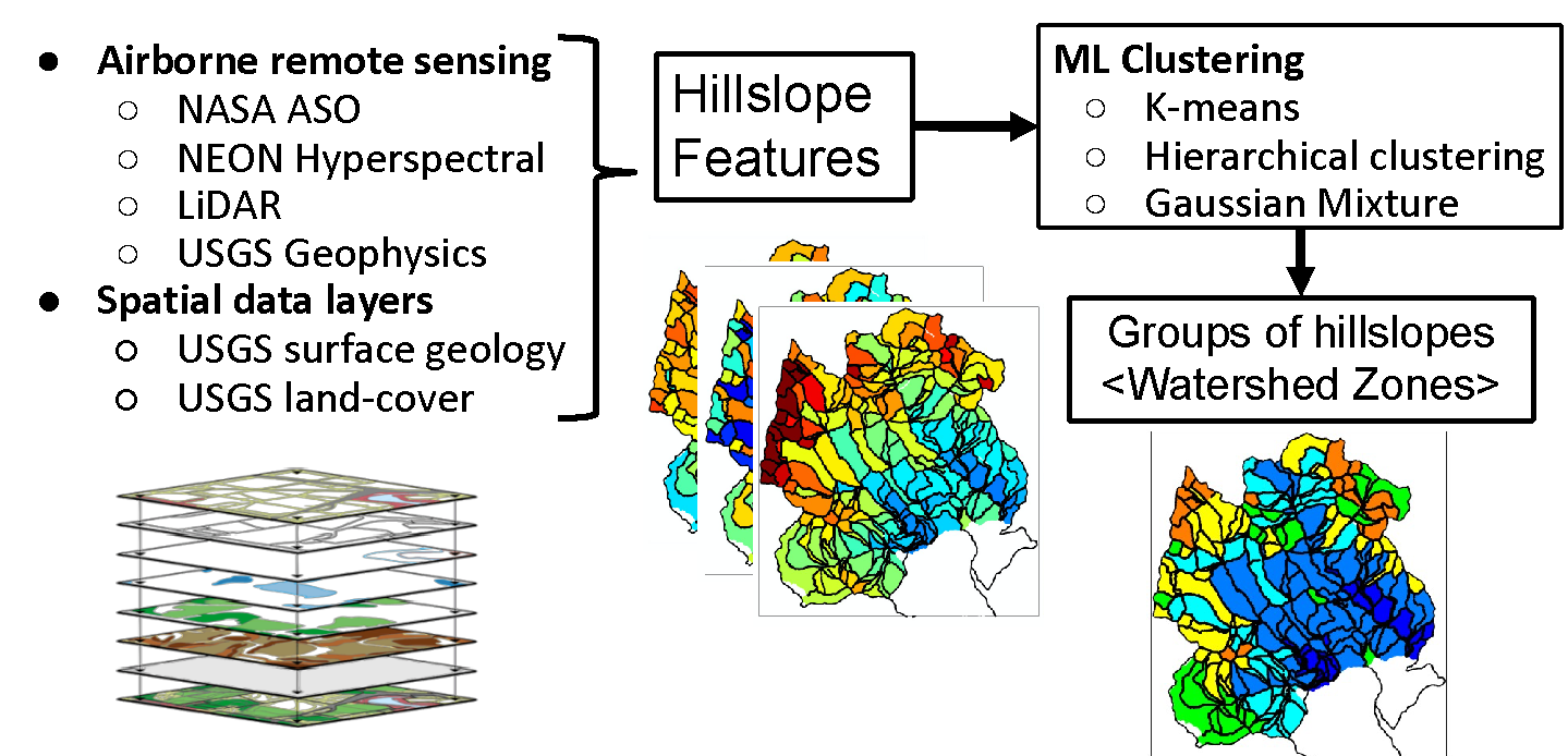
The Watershed zonation method applies unsupervised clustering to various spatial data layers for grouping hillslopes with similar above/below-ground environmental features
The Science
More than half of earth’s freshwater comes from mountainous watersheds. Watersheds are a “system of systems,” meaning there are many interacting compartments – such as bedrock, soil, and snow plants – that affect their functioning. Predicting watershed behavior is challenging because there are different environmental processes and characteristics– both at different scales and levels, from bedrock to the atmosphere– that affect watershed function and water quality. To understand how watersheds may respond to droughts as climate changes, researchers used data from the Colorado East River Watershed to develop a watershed zonation approach–a method that uses machine learning to characterize entire watersheds by grouping zones of similar functioning and characteristics, like watershed “zip codes.” The team grouped hillslopes specifically since these features are a functional unit in hydrology, capturing waterflow and a range of environmental characteristics like elevation, topography, and vegetation. This method not only combines data of multiple state-of-the-art arbonne remote sensing data layers of multiple types and scales to identify zones with similar bedrock-to-canopy features, but also shows how these areas respond to disturbances in different ways to advance holistic and large-scale predictions of watershed response to change.
The Impact
Watershed function can significantly impact energy production, agriculture, and water quality and availability. Now that environmental disturbances such as drought, wildfires, and floods mark what many have called a “new normal” state, scientists can no longer depend on historical trends to project future watershed behavior, but instead need to develop new approaches to studying watershed response to environmental changes. However, predicting watershed behavior is challenging because watersheds are extremely heterogeneous including the complex interactions taking place across different Earth compartments from tree canopy to the deep subsurface as well as from one hillslope in a watershed to another. – Using machine learning, researchers organized the watershed research site into zones based on similar environmental features, and were able to show how different zones process/export nutrients and respond to droughts. By using multiscale spatial data layers to capture different characteristics throughout a watershed, this approach allows for more accurate large-scale predictions of watershed responses to climate change. Understanding these responses is critical for managing and protecting critical freshwater resources as water demand continues to increase.
Summary
In this study, we develop a watershed zonation approach for characterizing watershed organization and function in a tractable manner by integrating multiple spatial data layers. We hypothesize that (1) a hillslope is an appropriate unit for capturing the watershed-scale heterogeneity of key bedrock-through-canopy properties, and for quantifying the co-variability of these properties representing coupled ecohydrological and biogeochemical interactions; (2) remote sensing data layers and clustering methods can be used to identify watershed hillslope zones having the unique distributions of these properties relative to neighboring parcels; and (3) property suites associated with the identified zones can be used to understand zone-based functions, such as response to early snowmelt or drought, and solute exports to the river. We demonstrate this concept using unsupervised clustering methods that synthesize airborne remote sensing data (LiDAR, hyperspectral, and electromagnetic surveys) along with satellite and streamflow data collected in the East River Watershed, Crested Butte, Colorado, USA. Results show that (1) we can define the scale of hillslopes at which the hillslope-averaged metrics can capture the majority of the overall variability in key properties (such as elevation, net potential annual radiation and peak SWE), (2) elevation and aspect are independent controls on plant and snow signatures, (3) near-surface bedrock electrical resistivity (top 20 m) and geological structures are significantly correlated with surface topography and plan species distribution, and (4) K-means, hierarchical clustering, and Gaussian mixture clustering methods generate similar zonation patterns across the watershed. Using independently collected data, we show that the identified zones provide information about zone-based watershed functions, including foresummer drought sensitivity and river nitrogen exports. The approach is expected to be applicable to other sites and generally useful for guiding the selection of hillslope-experiment locations and informing model parameterization.
Citation
Wainwright, H. M., Uhlemann, S., Franklin, M., Falco, N., Bouskill, N. J., Newcomer, M., … & Hubbard, S. S. (2022). Watershed zonation approach for tractably quantifying above-and-belowground watershed heterogeneity and functions. Hydrol. Earth Syst. Sci., 26, 429–444, 2022, DOI: 10.5194/hess-26-429-2022.
