Berkeley Lab

Systematic integration of emerging technologies into watershed network and collaboration strategies hold potential to significantly advance predictive understanding of watershed hydrobiogeochemical behavior

Systematic integration of emerging technologies into watershed network and collaboration strategies hold potential to significantly advance predictive understanding of watershed hydrobiogeochemical behavior.

This invited commentary documented how the emerging technologies listed above are starting to advance key elements important for predicting watershed hydrobiogeochemical behavior, including watershed characterization, data and informatics, and modeling. The commentary also described and recommended a systematic community development of co-design strategies, whereby the emerging technologies could seamlessly weave together characterization, data and modeling capabilities across scales, enabling two-way, near-real time feedback between observation and modeling systems.

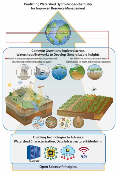
While society depends on watersheds for clean water, energy, agricultural productivity and other benefits, state-of-the-art scientific tools are not yet regularly used to underpin resource management. Recent advances in emerging technologies – together with instrumented watershed observatories, open-science principles and new modes of collaboration – offer significant potential to transform our ability to address complex scientific questions, develop generalizable insights, and propel accurate yet tractable approaches to predict watershed hydrobiogeochemical behavior. As resource managers struggle to make increasingly difficult decisions in the coming decades, we hope that the concepts described in this commentary will mobilize the scientific enterprise toward the systematic developments needed to provide actionable information over space and time scales useful for such decisions.

Summary

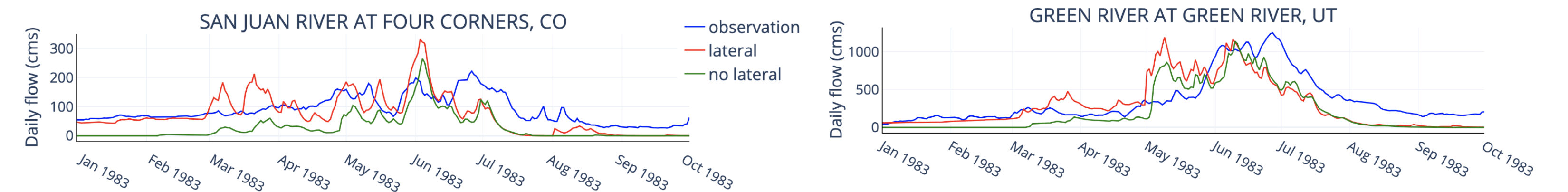
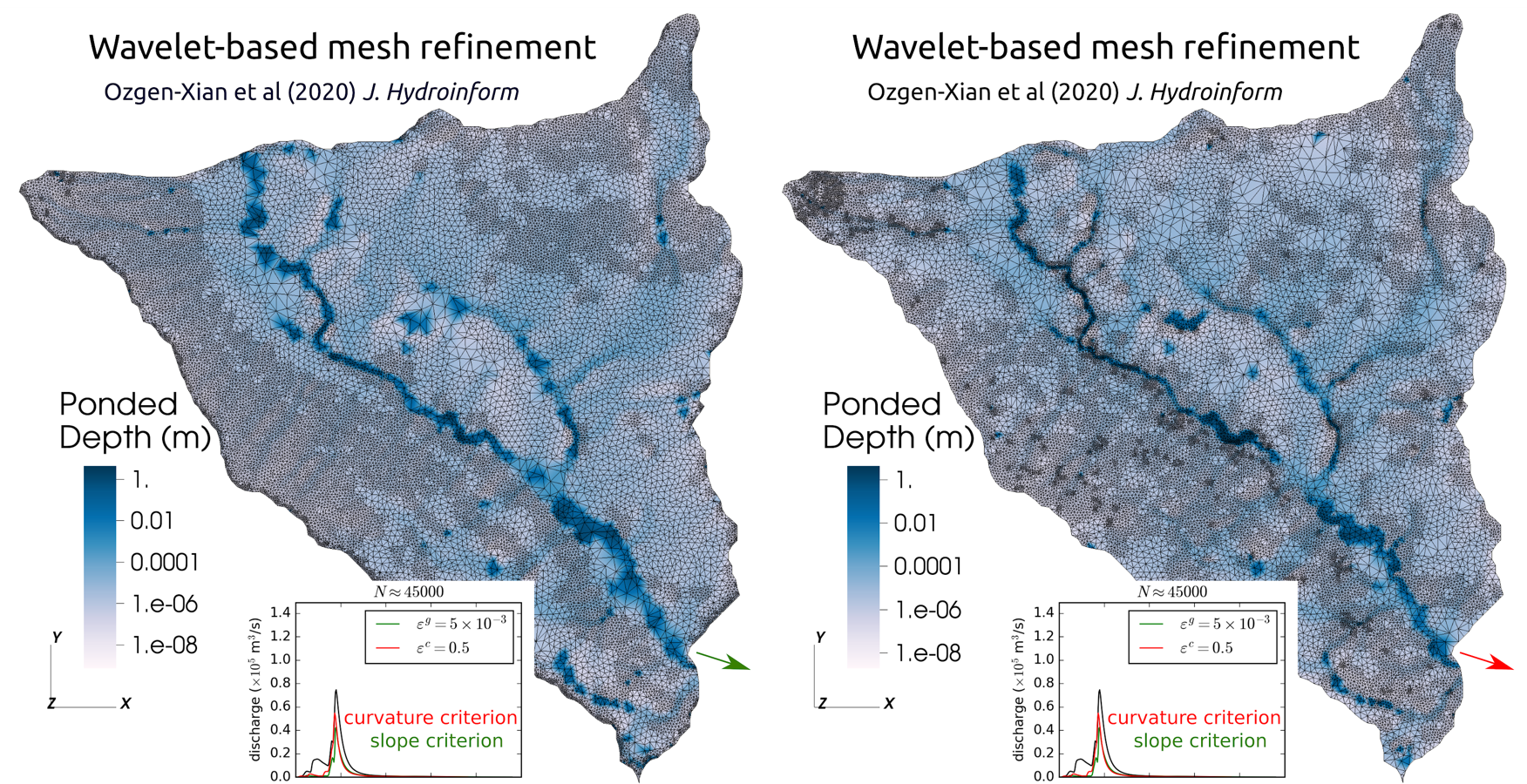
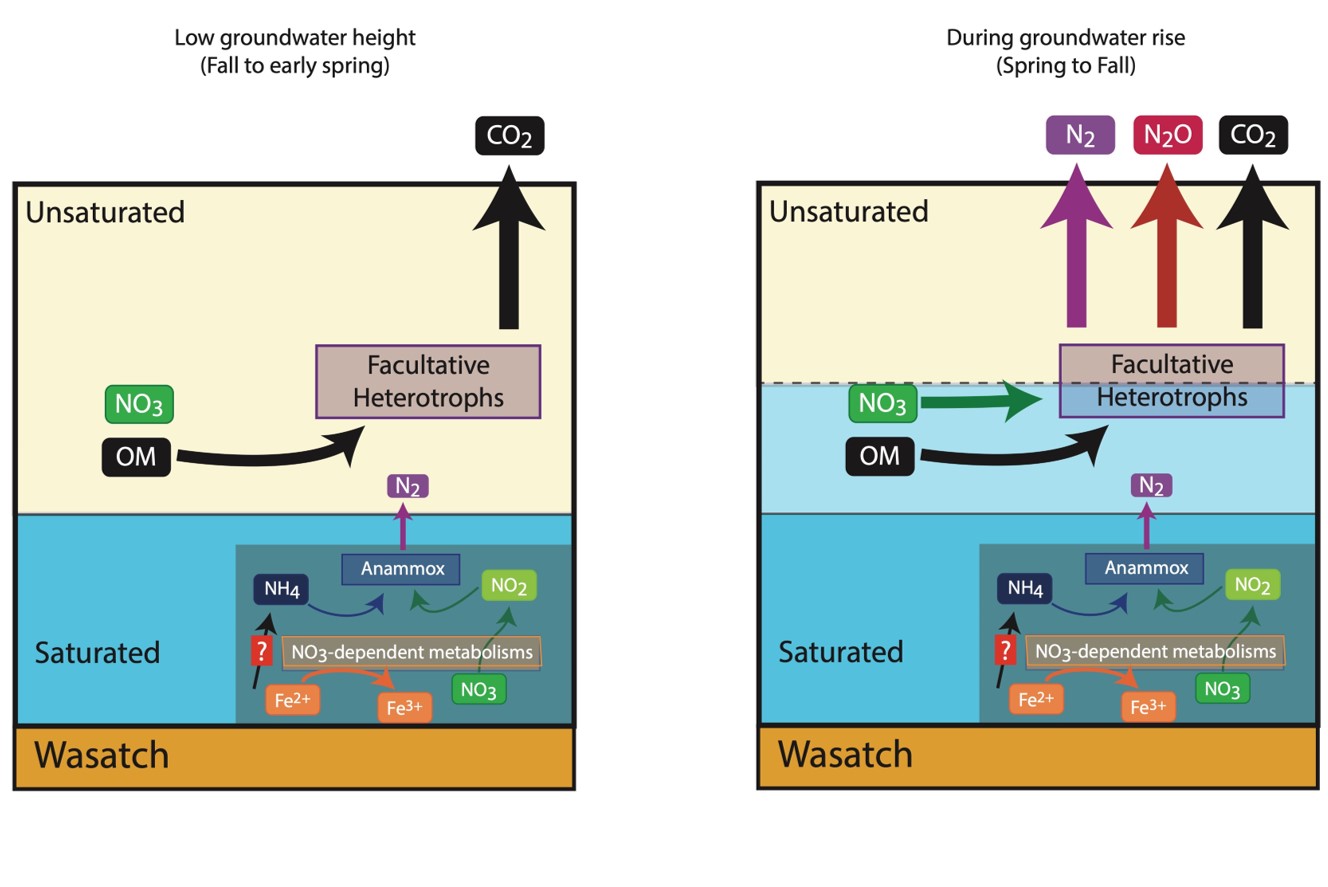
Several emerging technologies are now starting to reveal their promise for greatly enhancing the predictive understanding of watershed hydro-biogeochemical behavior, including machine learning and artificial intelligence, exascale computing, 5G wireless communications, and cloud data storage and compute capacity. We describe a co-design strategy to unify diverse characterization, data and simulation capabilities, allowing near real-time, autonomous communication and feedback between modelling and field observation systems. Paired with watershed observatory networks, open science principles, and radical collaboration strategies, the co-design strategies are expected to enable rapid progress on challenging scientific questions, such as: how do different types of watersheds respond to different stressors, such as climate change, droughts, floods, wildfire, and land-use? How will multiple stressors impact sustainability of municipal, industry, food, and energy systems that rely on water? Can generalizable metrics of resilience be identified and tracked? What is the minimum but sufficient amount of information needed to predict watershed behavior at temporal and spatial scales critical for underpinning resource management decisions? While systematic incorporation of emerging technologies and adoption of new modes of collaboration will require substantial coordination, resources and commitment to overcome technical, social, and organizational barriers, we are encouraged by the many recent efforts focused on advancing collaborations and tools across watershed communities, observatories, and government agencies.

Citation

Hubbard, S.S., C. Varadharajan, Y. Wu, H. Wainwright and D. Dwivedi, Emerging technologies and radical collaboration to advance predictive understanding of watershed hydrobiogeochemistry, Hydrological Processes, 35, DOI: 10.1002/hyp.13807

Simulating groundwater-streamflow connections in the Upper Colorado River Basin

A series of hypothetical numerical experiments with and without lateral groundwater flow is performed to isolate the role of lateral groundwater flow which are often over-simplified in traditional hydrologic model. Results show that that peak flows increase up to 57% when lateral groundwater flow processes are included.

The Upper Colorado River Basin (UCRB) is subject to climate extremes that pose a challenge to simulate and predict. Open questions remain about the correct model physical parameterization for accurate simulation of large, headwaters systems with a mix of terrain. Results show that including lateral groundwater flow component not only improving simulation accuracy but also quantifying the role of subsurface hydrological processes.

Stream flow time series for two representative stations in the Upper Colorado River Basin. Blue lines are observed daily flow, red and green lines are simulated flows from lateral and no lateral simulations respectively.

Summary

The Upper Colorado River Basin (UCRB) is subject to climate extremes that pose a challenge to simulate and predict. Open questions remain about the correct model physical parameterization for accurate simulation of large, headwaters systems with a mix of terrain. This study focusses on the role of lateral groundwater flow on total annual and peak streamflow in the UCRB using a physical hydrology model, ParFlow. Results for the simulated water year of 1983 (the high snowmelt year that almost destroyed the Glen Canyon Dam), suggest an increase in peak flow of up to 57% when lateral groundwater flow processed are included. This is an unexpected result for flood conditions, which are generally assumed to be independent of groundwater. Including lateral groundwater flow produces 25% to 50% more the larger downstream rivers in the domain and 20% to 40% less flow in headwater streams. These changes are mainly driven by hydraulic gradients in the subsurface which are often over-simplified in traditional hydrology models and can only be captured when lateral flow is considered. Lastly, the authors find that the impact of including lateral groundwater flow on the simulated flows exceeds the impact of an order of magnitude change in hydraulic conductivity. While the results focus on the UCRB, the authors feel that these simulations have relevance to other headwater systems worldwide.

Citation

Tran, H., J. Zhang, J.-M. Cohard, L. E. Condon, and R. M. Maxwell (2020), Simulating Groundwater-Streamflow Connections in the Upper Colorado River Basin, Groundwater, 58(3), 392-405, DOI: 10.1111/gwat.13000.

Generating Multiresolution Meshes for Distributed Hydrological Simulations

Multiresolution meshes are generated using a single error-threshold criterion, e.g. error in the approximation of topographic slope, thereby reducing the number of free parameters needed by other approaches. In the Lower Triangle Region of the East River CO watershed, two of such criteria are chosen: topographic slope and topographic curvature. Simulation results show that using curvature as refinement criteria is preferable in mountainous catchments.

The approach to generate multiresolution meshes is general in that it can be used with different criteria to refine a given mesh. Thus, it will make it possible to generate meshes to obtain accurate results for a broad range of processes.

Ponding water depth computed on the multiresolution meshes generated by a slope-based refinement criterion (left); and a curvature-based refinement criterion (right).

Summary

Multiresolution mesh generation usually utilizes a number of free parameters, which are tuned in a rather empirical manner. This study uses wavelet analysis—a mathematical method for signal analysis—to reduce the number of free parameters to exactly one: the acceptable error threshold. The authors apply the wavelet analysis on bed slope and the bed curvature to generate multiresolution meshes for high-intensity overland flow simulations. Case studies ranging from laboratory scale experiments to a sub-catchment of the East River Watershed, CO were carried out to compare results obtained on these meshes. For the latter case, computational results show that meshes generated by the curvature-based criterion give a more accurate prediction of stream discharge, which implies that in mountainous watersheds these flow processes are controlled by the curvature of the terrain. The wavelet approach is general enough to be used for different criteria to drive mesh refinement in addition to the ones demonstrated in the manuscript.

Citation

Özgen-Xian, I., G. Kesserwani, D. Caviedes-Voullième, S. Molins, Z. Xu, D. Dwivedi, J. D. Moulton, and C. I. Steefel (2020), Wavelet-based local mesh refinement for rainfall–runoff simulations, Journal of Hydroinformatics, DOI: 10.2166/hydro.2020.198.

Evidence for microbial mediated NO3- cycling within floodplain sediments during groundwater fluctuations

Schematic of the biogeochemical pathways cycling nitrogen at the capillary fringe of the Rifle floodplain, Colorado.

Alluvial sediments subject to the seasonal rise and fall of groundwater are regions of outsized biogeochemical activity relative to their spatial extent in many floodplain environments. This study documents significant changes in the nitrogen cycle under fluctuating hydrological conditions.

This manuscript significantly improves our understanding of the global nitrogen cycling by using natural abundance stable isotopes to document pathways and mechanisms leading to the accumulation and dissipation of nitrate under aerobic and anaerobic conditions.

Summary

In the current study, researchers characterize the nitrogen biogeochemistry of the subsurface at the Rifle Field Site, Colorado, as snowmelt driven fluctuations in water table depth change the saturation profile of the vadose zone sediments and hence their redox status. Depth-resolved water samples were collected over the course of a year with analysis of porewater nitrogen concentrations, nitrous oxide and nitrogen gas, and the natural abundance stable isotopes of nitrate (15NNO3 and (18ONO3) used to determine the role that abiotic and biological mechanisms play in the fate of nitrate. The study concludes that biological nitrogen cycling in Rifle sediments was predominantly attributable to temporally uncoupled nitrification-denitrification reactions. These reactions occur sequentially as aerobic conditions, favoring nitrification and the accumulation of nitrate, give way to anaerobic conditions, which favor denitrification rather than anaerobic ammonium oxidation, as the water table rises.

Citation

Bouskill, N. J., M. E. Conrad, M. Bill, E. L. Brodie, Y. Cheng, C. Hobson, M. Forbes, K. L. Casciotti, and K. H. Williams (2019), Evidence for Microbial Mediated NO3− Cycling Within Floodplain Sediments During Groundwater Fluctuations, Frontiers in Earth Science, 7(189), DOI: 10.3389/feart.2019.00189.

Roots Mediate the Effects of Snowpack Decline on Soil Bacteria, Fungi, and Nitrogen Cycling in a Northern Hardwood Forest

Photo: Root ingrowth cores were made out of nylon mesh (2-mm mesh size) which allowed roots to grow into and colonize the soil core. Root exclusion cores were made out of finer-sized nylon mesh (50-µm mesh size) that prevented root colonization.

Rising winter air temperatures are reducing seasonal snow cover in many temperate ecosystems, but the role of plant roots in moderating the impact of snowpack loss on bacterial or fungal communities remains poorly resolved. This study showed that declining winter snowpack and impacts to plant roots have direct effects on the diversity and abundance of soil bacteria and fungal communities with important consequences for N cycling in northern hardwood forests.

Summary

Impacts to soil biogeochemical processes have been investigated as they pertain to climate induced warming, with temperature increases having impacts on snow-dominated systems including reduced snowpack and early onset of melt. Little work to date has focused on the role that roots play in enhancing or moderating nutrient cycling in soils by bacteria and fungi. To address this gap in knowledge, root ingrowth and exclusion cores (216 cores total) were incubated in situ for 29 months at the Hubbard Brook Experimental Forest in central New Hampshire (USA) that has experienced winter snowpack decline over the past 50 years. Both a declining winter snowpack and its effect on plant roots each had a direct effect on the diversity and abundance of soil bacteria and fungal communities and interacted to reduce rates of soil N cycling in this northern hardwood forest. Such results are thought to be broadly relevant to other temperate ecosystems where climate change and climate disturbance are impacting snowpack, such as many mountainous regions worldwide.

Citation

Sorensen, P. O., J. M. Bhatnagar, L. Christenson, J. Duran, T. Fahey, M. C. Fisk, A. C. Finzi, P. M. Groffman, J. L. Morse, and P. H. Templer (2019), Roots Mediate the Effects of Snowpack Decline on Soil Bacteria, Fungi, and Nitrogen Cycling in a Northern Hardwood Forest, FRONTIERS IN MICROBIOLOGY, 10, DOI: 10.3389/fmicb.2019.00926.

Quantifying Snowmelt Recharge into Hillslope Soils and Rocks, and Solute Export to Rivers

Subsurface flow and transport. a. Seasonal variation in subsurface flow. b. Flow rates along soil, weathering zone, and bedrock. c. Seasonality of subsurface flow and specific conductance (SC) of discharging water. d. Concentration–discharge relation for SC.

Quantifying connections between snowmelt infiltration and seasonal variations in solute export to surface waters is frequently confounded by a lack of critical measurements. This study introduces a novel approach whereby distributions of fluid flow paths are highly resolved through the use of critical subsurface measurements to reveal their strong temporal sensitivity to snowpack accumulation and melt timing.

This study presents a novel methodological approach to quantify how hillslope subsurface flow and chemical transport contribute to stream flow and water quality.

Summary

Although most of the water entering watersheds permeates through soil and underlying bedrock before entering rivers, subsurface flow paths and their influence on river water chemistry are poorly understood. This study presents a new framework for quantifying depth- and time-dependent subsurface flow and solute transport along an intensively studied hillslope that utilizes in-situ hydrologic and geochemical measurements to constrain predictions. Results quantify the importance of abrupt groundwater excursions accompanying snowmelt for mobilizing dissolved chemicals in soil and weathered bedrock, with the latter responsible for the greatest contribution to solute export. The new concept of subsurface concentration-discharge relations was developed through this work that provides information needed to mechanistically explain solute concentrations and flow measured in rivers. With information on topography, meteorology, and subsurface hydraulic properties, this framework is broadly transferrable to other hillslope and watershed settings.

Citation

T.K. Tokunaga et al., “Depth- and time-resolved distributions of snowmelt-driven hillslope subsurface flow and transport and their contributions to surface waters.” Water Resources Research 55, 9474-9499 (2019). [DOI:10.1029/2019WR025093].

Shale is an Important Source of Organic Carbon in Floodplain Sediments of a Mountainous Watershed

Conceptual diagram showing two scenarios: (1) high litter input with low shale input, and (2) low litter input with high shale input. Scenario 1 is emblematic of regions of the floodplain with more extensive soil development (e.g., cut bank and middle of the meander) and non-shale systems, where OC is derived primarily from plant detritus and the 14C age is controlled by occlusion of litter fragments in aggregates (OLF), which physically protects it from degradation, and mineral protection of processed OC (e.g., partially oxidized and degraded) through adsorption or occlusion within mineral particles (HF). Scenario 2 (point bar) represents a shale-rich environment with low litter inputs, where the OC is derived from both shale and plant litter and 14C age of all pools except for FLF is lowered by the presence of shale-derived carbon. The role of shale-derived OC in CO2 release is currently unknown.

Shales contain high levels of organic carbon (OC) and represent a large fraction of the earth’s carbon stocks. Recent evidence suggests that shale-derived OC may contribute to the carbon cycle in some riverine systems, however this process is poorly understood and not currently considered in global C models. Through detailed sediment analysis coupled with radiocarbon measurements, and synchrotron carbon spectroscopy, this study determined the abundance, chemistry, and mobility of shale-derived OC in floodplain sediments of a shale-rich mountainous watershed.

Radiocarbon measurements reveal that 23-34% of OC in East River floodplain sediments is derived from shale, including types of sediment-OC which are considered to be relatively mobile and available for use by microbes. While the contribution of shale-derived OC to CO2 production and export is currently unknown in this system, the observation of shale-derived OC in carbon pools which is actively cycling suggests that this topic warrants further research. The results demonstrate the importance of shale weathering in the floodplain, particularly under low plant-litter environments, with implications for the global carbon budget and other shale-associated elements, including growth-limiting nutrients (e.g., N) and toxic elements (e.g., As, Se, U).

Summary

Shales contain high levels of organic carbon (OC) and represent a large fraction of the earth’s total carbon stocks. While recent evidence suggests that shale-derived OC, which is millions of years old, may be actively cycled in riverine systems, this process is poorly understood and not currently considered in global C models. In this study, the authors analyze sediments collected from the floodplain of the East River, Colorado, located in a high-elevation mountainous watershed underlain by shale bedrock, to determine the importance and mobility of shale-derived OC in this environment. OC closely associated with sediment minerals is the largest (84 ± 6%) and oldest OC pool, containing a large, but variable, amount of shale-derived OC. Evidence of shale-derived OC is also observed in other sediment OC pools which are considered to be more mobile and more easily degraded to carbon dioxide by bacteria (e.g., water-soluble). Carbon spectroscopy revealed that floodplain sediments had a higher degree of functionalized aromatic groups and lower carbonate content compared to shale collected nearby, consistent with chemical alteration and mixing with other C sources in the floodplain. This study concludes that there are two primary OC sources in floodplain sediments, plant-litter and shale-derived OC, each with distinct chemical characteristics and reactivity. The authors estimate 23-34% of the sediment OC is derived from shale, demonstrating the important contribution of shale-OC to the carbon cycle at this site, particularly in environments with low plant-litter inputs.

Citation

Fox, P. M., Bill, M., Heckman, K., Conrad, M., Anderson, C., Keiluweit, M., and Nico, P. S. “Shale as a Source of Organic Carbon in Floodplain Sediments of a Mountainous Watershed.” Journal of Geophysical Research: Biogeosciences, 125, (2020). DOI: 10.1029/2019JG005419

Seasonal snowmelt drives changes in alpine stream bed microbiome structure and function

Location study site within the East River near Crested Butte, CO, part of the Upper Colorado River Basin.

Within the East River, near Crested Butte, CO, shifts in microbial composition and activity were observed in both stream water and the streambed associated with water mixing patterns, highlighting the tight linkage between microbial community assembly and function, and seasonal changes in hydrology. Specifically, rates of aerobic respiration increased during spring snowmelt, linked to the influx of abundant dissolved organic carbon. Moreover, strong river water downwelling into the riverbed had the additional effect of homogenizing the microbial community composition across depth profiles through the bed.

This work revealed multiple close linkages and feedbacks between physical, chemical, and microbiological processes in headwater streambed ecosystems, and highlights the need for increased characterization of upland biogeochemical cycles under future climate change scenarios.

Summary

Seasonal changes in river discharge in upland watersheds affect patterns of surface and groundwater mixing in the hyporheic zone (the region in the riverbed where these two water sources interact) that impacts how carbon compounds and dissolved metals are processed and exported from such catchments. This study focused on seasonal patterns of hyporheic mixing in the East River, CO, where seasonal snowmelt drives large fluctuations in the annual hydrograph. Using in situ depth-resolved temperature loggers and discrete sampling of pore fluids and riverbed sediments, we demonstrated that snowmelt-derived runoff drives increased downwelling of river water into the riverbed. Conversely, the riverbed experienced a greater influence from upwelling groundwater under low- and base-flow conditions. The movement of dissolved solutes was strongly correlated with seasonal changes in flow. Under high river discharge, increased dissolved oxygen concentrations in riverbed pore fluids stimulated aerobic heterotrophic metabolism, while conversely, this activity was depressed under baseflow conditions. Linked to changes in microbiome function, we demonstrated that this dynamic hydrology also influenced microbial community assembly; strong downwelling river water conditions had the effect of homogenizing microbial community composition across depth profiles through the riverbed.

Citation

C. M. Saup, S. R. Bryant, A. R. Nelson, K. D. Harris, A. H. Sawyer, J. N. Christensen, M. M. Tfaily, K. H. Williams, and M. J. Wilkins. (2019). “Hyporheic zone microbiome assembly is linked to dynamic water mixing patterns in snowmelt‐dominated headwater catchments.” Journal of Geophysical Research: Biogeosciences, 124, DOI: 10.1029/2019JG005189

Spatial heterogeneity in streambed biogeochemistry

Intrameander flow paths result in lateral heterogeneity in streambed surface water-influence (a), dissolved oxygen (b), and specific UV absorbance at 254 nm (SUVA254, c, indicator of organic compound aromaticity). Water flow in channel is clockwise.

During baseflow within an alpine river, meander morphology was found to cause lateral spatial variability in channel hyporheic flow and drive streambed biogeochemical conditions. Sinuosity-induced intrameander flow paths affect the source and lability of dissolved organic matter, and streambed microbial community composition shifts with chemistry conditions, although communities are all similarly diverse.

The progression of climate change is resulting in earlier snowmelt onset and reduced snowpack in alpine regions, causing a longer baseflow period for alpine streams and subsequently impacting streambed flow and biogeochemical processes. This study characterized streambed biogeochemistry at high-resolution during baseflow to constrain how nutrient cycling in alpine watersheds may shift with climate change.

Summary

The authors conducted a high-resolution characterization of streambed hydrology and biogeochemistry around a prominent meander bend within the East River (Crested Butte, CO) and found sinuosity-induced heterogeneity in hyporheic flow, pore water chemistry, and microbial community composition. The presence of intrameander flow paths result in spatial heterogeneity in the upwelling and downwelling of water, and subsequent surface water influence in the streambed. Surface water downwells in a large recharge zone on the up-valley side of the meander, and discharges on the down-valley side of the meander. Variability in hyporheic flow resulted in similar patterns in pore water chemistry and concentrations of substrate for microbial metabolism. Regions of the streambed with large surface water influence have higher dissolved oxygen concentrations, relatively low metal concentrations, and more labile, fresh dissolved organic matter. Contrastingly, groundwater-dominated regions have low dissolved oxygen and high metal concentrations, and more recalcitrant dissolved organic matter. Lateral heterogeneity in pore water chemistry drives microbial community composition, although streambed microbial communities are similarly diverse. The authors’ findings enhance understanding of hyporheic biogeochemical conditions during baseflow, which is expected to lengthen with climate change.

Citation

A. R. Nelson, A. H. Sawyer, R. S. Gabor, C. M. Saup, S. R. Bryant, K. D. Harris, M. A. Briggs, K. H. Williams, M. J. Wilkins (2019), “Heterogeneity in hyporheic flow, pore water chemistry, and microbial community composition in an alpine streambed.” Journal of Geophysical Research: Biogeosciences, DOI: 10.1029/2019JG005226

Predicting sedimentary bedrock subsurface weathering fronts and weathering rates

The new conceptual model coupling subsurface water table positions with weathering fronts of multiple minerals and components in sedimentary bedrocks. The water table remains approximately parallel to the soil surface along the hillslope. The deepest seasonal water table determines the pyrite weathering front. Carbonate minerals and fossil-organic matter share the same weathering front with pyrite.

For the first time, subsurface bedrock weathering rates were directly determined from in-situ measurements. The weathering front coincides with the depth of deepest seasonal water table for sedimentary bedrocks. Carbonates and rock organic matter share the same weathering front depth with pyrite, contrary to models that stratify their weathering fronts.

This new conceptual model linked to subsurface hydrology makes predictions of bedrock weathering fronts and rates more feasible, and connects to water quality and climate change impacts. The approach can be applied to other settings of a watershed.

Summary

Although bedrock weathering strongly influences water quality and global carbon and nitrogen budgets, the weathering depths and rates within subsurface are not well understood nor predictable. Determination of both porewater chemistry and subsurface water flow are needed in order to develop more complete understanding and obtain weathering rates. In a long-term field study, this study applied a multiphase approach along a mountainous watershed hillslope transect underlain by marine shale. Three findings are reported in the study. First, the deepest extent of the water table determines the weathering front, and the range of annually water table oscillations determines the thickness of the weathering zone. Below the lowest water table, permanently water-saturated bedrock remains reducing, preventing deeper pyrite oxidation. Secondly, carbonate minerals and potentially rock organic matter share the same weathering front depth with pyrite, contrary to models where weathering fronts are stratified. Thirdly, the measurements-based weathering rates from subsurface shale are high, amounting to base cation exports of about 70 kmolc ha−1 y−1, yet consistent with weathering of marine shale. Finally, by integrating geochemical and hydrological data, a new conceptual model is presented that can be applied in other settings to predict weathering and water quality responses to climate change.

Citation

Wan, J., Tokunaga, T. K., Williams, K. H., Brown, W., Dong, W., & Hubbard, S. S., Predicting sedimentary bedrock subsurface weathering fronts and weathering rates. Scientific Reports, 2019, DOI: 10.1038/s41598-019-53205-2