
Scientists develop a framework to better understand a watershed’s response to environmental change over space and time.
The Science
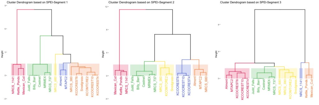
A new statistical framework is developed to assess changes of climatic conditions, using data from 17 meteorological stations across the East River watershed near Crested Butte, CO, spanning the period from 1966 to 2021. Time series segmentation and clustering of similar watershed sites demonstrate considerable changes in climatic conditions with time and space. The response to a changing climate is non-uniform across the watershed. A significant shift in the cluster arrangements for the temporal segments indicate that zonation patterns are driven by dynamic climatic processes, which change throughout time and space. Grouping similar watershed areas into zones, by means of hierarchical clustering of site locations for the three temporal segments of the Standardized Precipitation-Evapotranspiration Index (SPEI), showed significant temporal-spatial shifts, indicating that dynamic climatic processes drive zonation patterns.
The Impact
Mountainous watersheds provide 60-80 percent of Earth’s freshwater in addition to other life-sustaining ecosystem services, such as air and water quality regulation and carbon sequestration. Analyzing long-term spatial and temporal climate data in these important regions can help scientists understand how these critical ecosystems may respond, or are already responding, to a changing climate. Scientists developed a statistical framework to assess the changes in climatic conditions in Colorado’s East River Watershed. The assessment indicates considerable changes in climatic conditions with time and space, demonstrating that not only is climate change affecting the watershed, but different zones are responding in different ways. Understanding these changes can help researchers predict and monitor how the ecosystems, in addition to the services they provide, may change in order to better adapt to climate change.
Summary
Researchers developed a statistical framework to assess long-term temporal and spatial variability of meteorological conditions including temperature, dewpoint, precipitation, relative humidity, and wind speed, as well as time series of potential and actual evapotranspiration, Standardized Precipitation Index, and Standardized Precipitation-Evapotranspiration Index. Calculations were conducted for the period from 1966 to 2021 for 17 locations of meteorological stations located within the East River Watershed, Colorado, which is a typical watershed in the Upper Colorado River Basin providing freshwater to millions of Americans. Time series segmentation analysis and zonation demonstrate considerable changes in climatic conditions with time and space, demonstrating that the response to changing climate forcing is non-uniform across the watershed. A significant shift in the cluster arrangements for the temporal segments indicate that zonation patterns are driven by dynamic climatic processes, which are variable through time and space. Therefore, the watershed climatic zonation requires periodic re-evaluation based on the climatic changes with space and time.
Contact
Boris Faybishenko
Lawrence Berkeley National Laboratory
Funding
The work was conducted as part of the Watershed Function Scientific Focus Area at Lawrence Berkeley National Laboratory, and was supported by the U.S. Department of Energy (DOE) Environmental Systems Science Program, DOE Office of Science, Office of Biological and Environmental Research, under Contract Number DE-AC02-05CH11231.
Publications
Faybishenko,B., B.Arora, D.Dwivedi, E. Brodie, “Statistical Framework to Assess Long-Term Spatio-Temporal Climate Changes: East River Mountainous Watershed Case Study,” Stochastic Environmental Research and Risk Assessment (2022). DOI: 10.1007/s00477-022-02327-7