
Waveform LiDAR provides new insights into the connections between snow, topography, and subalpine forest structure
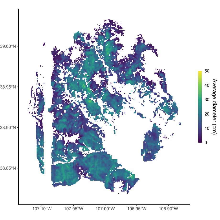
Image: Average conifer tree stem diameter derived from waveform LiDAR and field census data in the East River Watershed, Colorado, USA, shown at 100 m grid resolution.
The Science
The research team explored how the local environment influences the sizes and types of trees in high-elevation forests. Using aircraft-based remote sensing data and on-the-ground surveys, the researchers examined the influence of environmental factors—such as climate, elevation, radiation, soils, and geology—on several common measures of tree size, forest density, and species makeup in subalpine forests in Colorado. They demonstrated that a site’s snowpack, snow melt rate, and elevation had the strongest influence. The largest trees and the greatest density of trees occurred in areas between 3000 and 3200 meters in elevation with slightly below-average snowpack and slow snow melt.
The Impact
The study’s findings highlight the importance of snow for subalpine forests. A future with warmer temperatures and less snow could cause these forests to become sparser or disappear entirely. Subalpine forests regulate how long snow stays on the ground and how much water moves from the soil into the atmosphere. So, changes in their size, density, and the species that make them up could influence the amount of water that flows through the major river basins of the Western U.S. This study provides a needed foundation for accurately predicting how these ecosystems will respond to environmental change, and how the responses will affect water availability downstream.
Summary
Understanding the environmental factors that influence high-elevation forests is crucial for predicting how mountain ecosystems will respond to new environmental pressures. Previous studies of these relationships have often used small samples from broader landscapes, which limits their ability to identify effects and interactions. In this study, the authors present the first comprehensive assessment of how environmental factors influence conifer forest structure (the vertical and horizontal arrangement of trees) and composition (the variety and abundance of species) across an entire watershed. In subalpine conifer forests in the Colorado Rocky Mountains (USA), the research team developed a new method to analyze forest structure using waveform LiDAR data, which closely matched field measurements.
The researchers then examined how several characteristics of forest structure and composition relate to climate, topography, soil, and geology. The findings revealed that peak snow water equivalent (SWE), snow melt rate, and elevation were the main factors influencing stand density, basal area, maximum canopy height, and average tree diameter. Specifically, areas with SWE about one standard deviation below the mean and longer snow cover supported the largest and densest forest stands. Stand density declined steadily with elevation, while other forest metrics peaked between 3000 and 3200 m. The study provided detailed insights into how forest structure and composition vary along environmental gradients. The insights and underlying data are being applied to improve representation of subalpine forests in vegetation demographic models, such as the Functionally Assembled Terrestrial Ecosystem Simulator (FATES).
Contact
Lara Kueppers
lmkueppers@berkeley.edu
Publications
Worsham, H. M., Wainwright, H. M., Powell, T. L., Falco, N. and Kueppers, L. M., (2025). Abiotic influences on continuous conifer forest structure across a subalpine watershed. Remote Sensing of Environment 318: 114587. doi:10.1016/j.rse.2024.114587
Worsham H M ; Wainwright H ; Powell T ; Falco N ; Kueppers L (2025): Data from: ‘Abiotic influences on continuous conifer forest structure across a subalpine watershed’. Integrating tree hydraulic trait, forest stand structure, and topographic controls on ecohydrologic function in a Rocky Mountain subalpine watershed, ESS-DIVE repository. Dataset. doi:10.15485/2404585
Goulden T ; Worsham H M ; Hass B ; Brodie E ; Chadwick K D ; Falco N ; Maher K ; Wainwright H ; Williams K ; Kueppers L (2024): NEON AOP Survey of Upper East River CO Watersheds: Waveform LiDAR Binary Data. Watershed Function SFA, ESS-DIVE repository. Dataset. doi:10.15485/2403350