Berkeley Lab

June 2017 – Peak discharge at Pumphouse floodplain and Meander C shale outcrop conditions

A brief update is below on site conditions at East River and in particular the Pumphouse floodplain. These dates correspond to conditions during or very near peak discharge at this location.

June 5th, 2017:

June 7th, 2017:

Additionally, included is a video of the shale outcrop and associated water line relative to the incised marker bed that Joel Rowland has observed in the past and which he considers to represent the last high water runoff mark. We’re very close to this level this year.
May 2017 – Wintertime conditions at meanders A-to-C and East River EC Flux Tower

Meander A on May 4th, 2017:
[N.B. I inadvertently refer to Meander L as “Meander D” in this video; the video presents Meander L where Paula Matheus is undertaking her genomics sampling]

Meander A-to-C bank erosion:

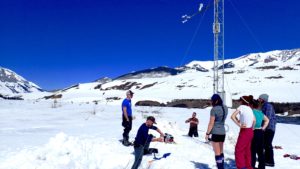
East River Eddy Covariance Flux Tower on May 4, 2017:

East River Eddy Covariance Flux Tower on May 6, 2017 — significant snowmelt:

April 2017 – Flux Tower Deployment and Peak SWE Snow Sampling

Flux tower installation at Pumphouse floodplain site

Flux tower being installed at the Pumphouse floodplain site.

Tied to the DOE-funded project led by Drs. Reed Maxwell and Dave Gochis (“Diagnosing dominant controls on carbon exchanges in high altitude, western U.S. headwaters”), the long-awaited flux tower was installed at the Pumphouse floodplain intensive study site on April 13, 2017.

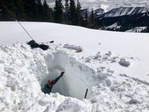
Tony Brown (~6ft tall) standing in the 3-meter snow pit at the Upper Subalpine site.

Sampling during peak SWE (Snow Water Equivalent) conditions

On April 2-3, 2017, SFA team members dug snow pits to collect vertically-resolved measurements of snow density and samples for geochemical analysis.  Snow depths were ~50% greater than in 2016 at the same time of year.
A video highlighting conditions at the Upper Subalpine site and the headwaters of Rock Creek at the time of sampling is linked below.

Flux tower installation:

Synoptic view of flux tower installation and site conditions and infrastructure:

Upper Subalpine site conditions:

Other site updates

For those who have followed the time-lapse evolution of conditions on Meander A, a video presenting conditions and infrastructure tied to the DOE-funded work of Mike Wilkins (Ohio State) investigating stream bed hyporheic exchange can be found below:

March 2017 – Wintertime conditions of relevance

Below are four video postings of relevance to wintertime conditions and ongoing science activities.

Snow conditions along the Washington Gulch satellite site elevation gradient:

Snow conditions and science activities at the Pumphouse Floodplain Meander A:

Pumphouse meteorological station status:

Snow pit sampling at the Pumphouse Ecohydrology study plots:

February 2017 – Pumphouse Intensive Sites

Below are videos giving a virtual tour of sites under this year’s deep snowpack.

Meander A:

Pumphouse Meterological Station:

Electrical Resistivity Tomography (ERT) Monitoring Station:

Lower Montane Hillslope:

Snowpack and Snow Water Equivalent levels continue to be quite elevated this season, with snow depths in the videos ranging from 140-170 cm at the time they were recorded.