Berkeley Lab

Predicting Watershed Function and Response to Disturbance

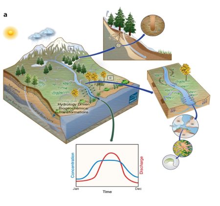
Figure: The Watershed Function project is developing and testing system-within-system, scale-adaptive approaches at the East River, CO Watershed to quantify how spatially variable hydrological-biogeochemical responses to perturbations propagate through the system and lead to an aggregated downgradient watershed discharge and concentration signature.

While watersheds are recognized as Earth’s key functional unit for managing water resources, their hydrological interactions also mediate biogeochemical processes that support all terrestrial life and can lead to a cascade of downgradient effects. The Watershed Function Scientific Focus Area is developing a scale-adaptive predictive understanding of how mountainous watersheds retain and release water, nutrients, carbon, and metals. This paper describes several recently developed approaches to interrogate, monitor and simulate transient watershed partitioning and biogeochemical responses – from genome to watershed spatial scales and from episodic to decadal timescales.

A growing demand for clean water, food, and energy — in parallel with droughts, floods, early snowmelt and other disturbances — are significantly reshaping interactions within watersheds throughout the world. This is particularly true for mountainous systems, such as the East River Watershed in CO, which is located in the Upper Colorado River Basin. This Basin supplies water to 1 in every 10 Americans and supports vast agriculture and hydropower operations along its reach. Because society is dependent on watersheds, new approaches that can accurately yet tractably predict watershed responses to disturbances are critical for resource management.

Summary

The Watershed Function project is developing new approaches to quantify and predict how disturbances impact downstream water availability and biogeochemical cycling, with a current focus on early snowmelt. The research is guided by a system-of-systems perspective and a scale-adaptive approach, where a predictive understanding of the response of archetypal watershed subsystems to disturbances is being developed as well as methods to aggregate such responses into predictions of cumulative watershed exports. The paper describes several recent advances, including above-and-below ground characterization and monitoring approaches for understanding vegetation distribution; new modeling approaches for predicting bedrock-through-canopy hillslope interactions; and coupled modeling approaches that can assimilate increasingly available streaming data into models to estimate hillslope water partitioning over time. The paper also describes new watershed function insights gained through the use of such tools, including: how historical snowmelt and monsoon characteristics influence annual discharge across the entire watershed; controls on streamflow generation; and how future changes in vegetation and temperature may influence water partitioning at different positions in the watershed. Over 30 institutions are involved in advancing watershed hydrological-biogeochemical science at the East River CO DOE-BER ‘community testbed’.

Citation

Hubbard, S.S. et al. (2018) The East River, CO Watershed: A Mountainous Community Testbed for Improving Predictive Understanding of Multi-Scale Hydrological-Biogeochemical Dynamics. Vadose Zone Journal, Special Issue on ‘Hydrological Observatories’, doi: 10.2136/vzj2018.03.0061 in press.
July 2018 Redwell Basin site visit/update

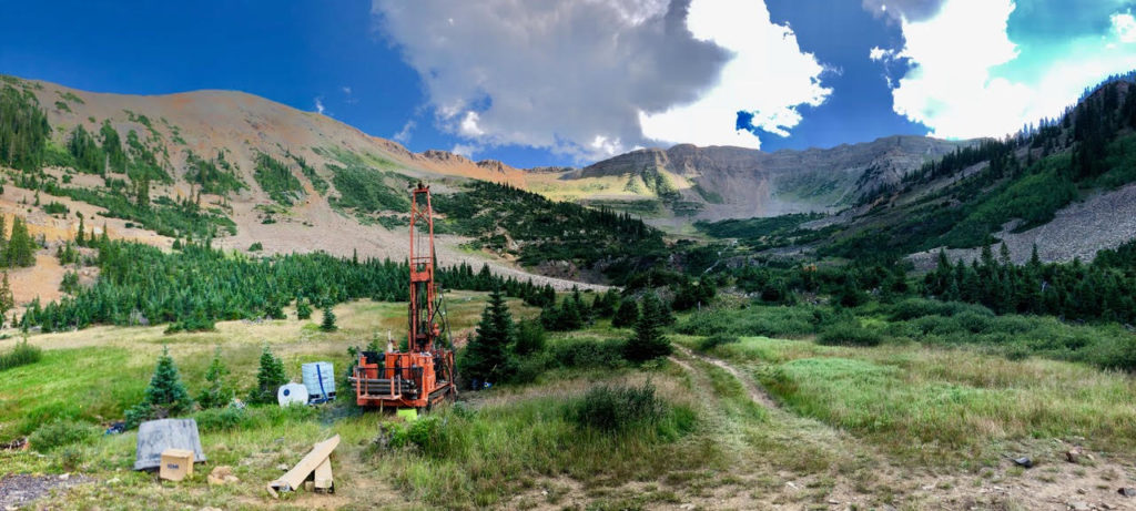
Below is a virtual site visit from this past Thursday at our lower elevation drilling location in Redwell Basin:

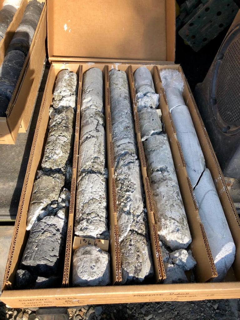
Drilling has gone quite well, with ore mineralization very abundant. Indeed, cores recovered from a highly fractured / faulted location at depth show massive metal sulfide mineralization even given the considerable distance from the felsite intrusion. As with the higher elevation site (MW1) drilled last September, Andy Manning and Lyndsay Ball of the USGS are leading the scientific charge. For those unfamiliar, a previously-shared “Meet the Scientist” video presenting their research program in the Redwell Basin is below.

While we had hoped to achieve a total depth exceeding 300-ft, artesian flow upon reaching a high permeability zone at ca. 145-150-ft below grade has necessitated a halt to drilling. Andy and Lyndsay are working today to devise a strategy for isolating this high permeability / artesian zone such that it can be sampled and monitored in the future. Shallower, nested sampling ports will be installed using the same well completion approach used at MW1. Lastly, a shallow (ca. 15-ft depth) portion of the open hole is unstable and work today is geared towards setting a surface casing to maintain borehole integrity for the next week or so as a suite of open hole geophysical logging measurements are collected.

Once completed, the rig will move back uphill to the MW1 location and drill a shallow (ca. 30-ft) vadose zone / capillary fringe monitoring borehole that will enable our team to examine hydrogeochemical processes in this dynamic region. Conversations between Andy Manning and recently funded PI Danielle Rempe (Univ. Texas) at the 2018 DOE ESS PI Meeting inspired this new monitoring hole thus highlighting the great value in that meeting for catalyzing new and novel research plans.

Here in the Elk Mountains of Colorado it continues to be very warm with summer rainstorms beginning to some degree but as of yet not providing much relief for drought-stressed conditions. Soils are incredibly dry throughout the East River area and stream flows are getting very low with high water temperatures. A challenging summer for the plants and critters, I’m afraid.


Summer 2018 update and “Meet the Scientist: Kate Maher (Stanford)”

New DOE University projects at East River announced
The US Department of Energy (DOE) has recently announced funding awards for six new university investigators working with Berkeley Lab and its myriad collaborators in the East River / Upper Gunnison. While some of these individuals have been or are currently working with us — some having previously presented to this group — others are new to the watershed and the project. We congratulate and welcome the contributions of the new scientists!

  • Jeff Deems (CU Boulder) will utilize multi-scale, seasonal snowpack observations and modeling to more accurately account for water and solute storage and fluxes within the upper Gunnison basin.
  • McKenzie Skiles (Univ. Utah) and Co-PI’s Janice Brahney (Utah State Univ.) and David Gochis (NCAR) will better constrain our physical understanding of aerosol loading, biogeochemistry, and snowmelt hydrology from hillslope to watershed scale within the East River watershed and its surrounding drainages.
    • Both projects will rely heavily on data collected by NASA’s Airborne Snow Observatory and funded by the Colorado Water Conservation Board.
  • Alejandro (Lejo) Flores (Boise State Univ.) and Co-PIs Rosemary Carroll (Desert Research Institute) and Haruko Wainwright (LBNL) will be working to advance our ability to accurately predict the spatiotemporal distribution of snow cover and water content across multiple scales by combining land-atmosphere models with operational, multi-satellite remote sensing data.
  • Max Berkelhammer (Univ. Illinois, Chicago) and Co-PI Chris Still (Oregon State Univ.) will be installing a network of sapflow sensors and automated dendrometers that will be coupled with stable water isotope measurements to study subsurface hydrologic and physiological controls on transpiration across the East River watershed.
  • Marco Keiluweit (Univ. Massachusetts) will be investigating the impact of plant root-mediated organic matter mobilization on soil carbon loss and nutrient export in mountainous watersheds, with a focus on the East River.
  • Lee Liberty (Boise State Univ.) will be working with Berkeley Lab collaborators to utilize scale-dependent seismic imaging to estimate regolith, rock and fluid distributions in association with upcoming and planned drilling activities in the greater East River watershed.

A quick note to new scientists engaging in field work at East River: Prior to undertaking field research (i.e., ground-based work), please reach out to Dr. Jennie Reithel (jreithel@gmail.com), the Science Director at the Rocky Mountain Biological Lab (RMBL). Jennie is the primary point of contact for facilitating research activities within the greater watershed to ensure seamless integration with other RMBL scientists. She and I will work closely to ensure that your work is integrated into the existing Special Use Permits issued to RMBL and Berkeley Lab by the U.S. Forest Service.

Upcoming drilling in the Redwell Basin
Drilling of the lower elevation monitoring well (MW2) will begin the week of July 16th, 2018. This work will involve continuous coring to a depth of ca. 300-350 feet with an expectation of collecting samples from both the Cretaceous Mesa Verde formation and the underlying Mancos Shale. As with last year’s drilling at well MW1, this work will include downhole packer testing for vertically resolved estimates of hydraulic conductivity, open hole borehole geophysical logging, and multi-depth completions for sampling groundwater at discrete depths. For those who will be in the watershed during that week and have an interest in observing the activity, please correspond with myself and/or the USGS leads: Andy Manning (amanning@usgs.gov) and Lyndsay Ball (lbball@usgs.gov).

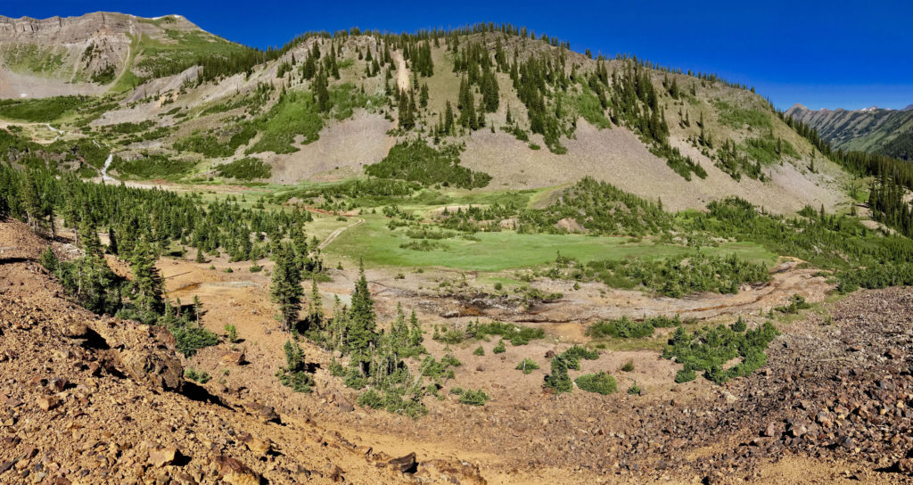
The impacts of the low snowpack year and very dry late spring / summer are especially evident up in the Redwell Basin. The below photo looking toward the new MW2 drilling site (center of the photo) illustrates just how little snowmelt and groundwater discharge we’re seeing this year as compared to most ‘average’ years.

Speaking of MW1, below are two virtual site visits of that location assessing the impact of a large avalanche that cut loose in the Redwell Basin this past winter.

June 21, 2018

July 2, 2018

NEON Airborne Observation Platform and “Meet the Scientist: Kate Maher”
Kate will be providing a more detailed update on the work and next steps as part of the July 17th Watershed Science Community Call. That said, a virtual site visit of some ground-based sampling is in order, as is a related “Meet the Scientist” video featuring Dr. Kate Maher.

NEON sampling

Meet the Scientist: Kate Maher

April 2018 – Spring Update

JPL/NASA Airborne Snow Observatory (ASO)

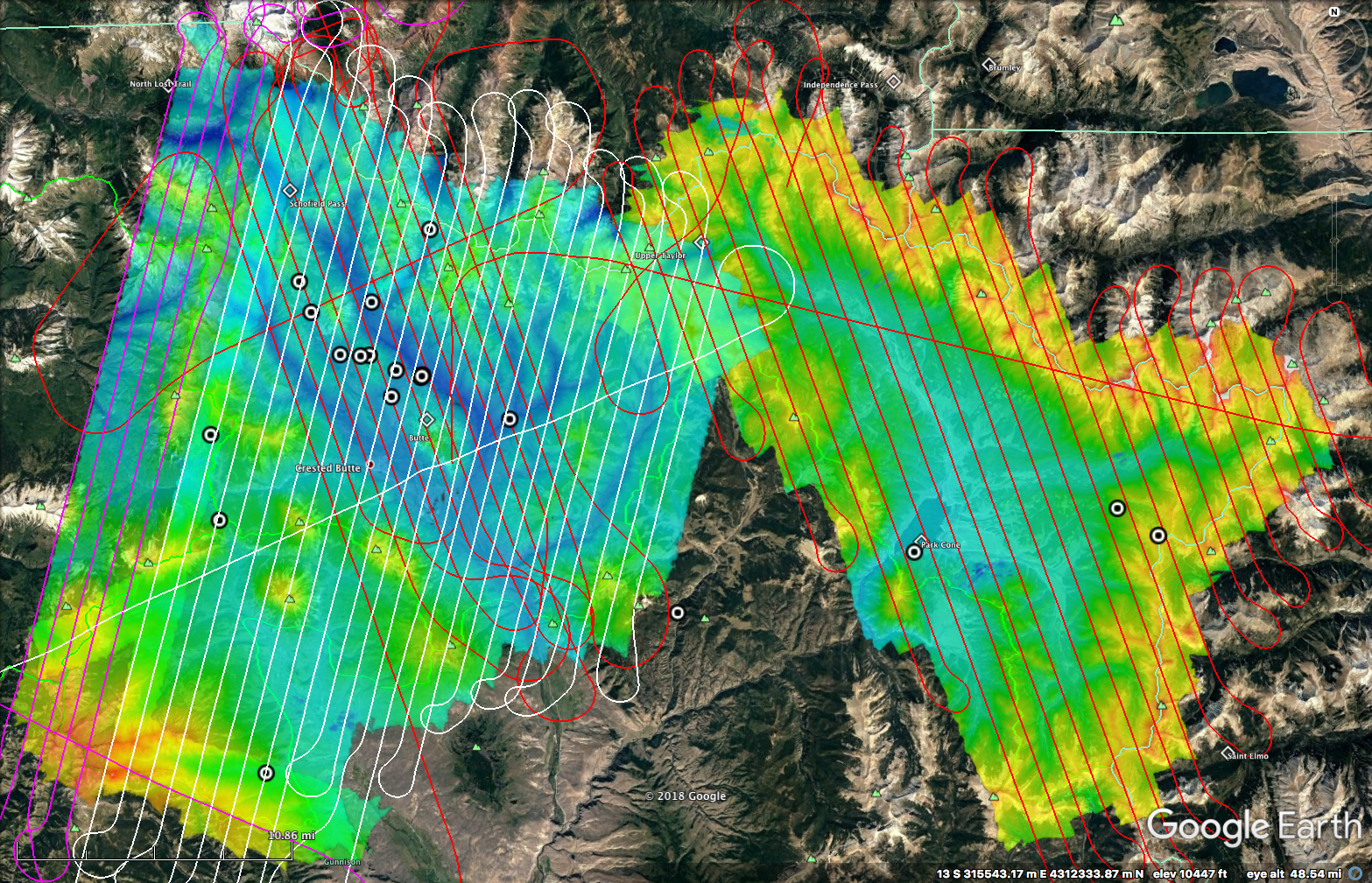
With generous financial support from the State of Colorado Water Conservation Board (CWCB), as well as critical guidance and input from Frank Kugel and John McClow of the Upper Gunnison River Water Conservancy District, the first of two “snow-on” ASO overflights of the East River, Taylor River, and Ohio Creek watersheds has been completed.  The first flight was designed to coincide with so-called “peak snow water equivalent (SWE)” and took place over the last 2 days of March and first of April.  Concomitant with this overflight, 18 snow pits were dug in order to have direct confirmation of snow depth and SWE at locations throughout the area of investigation.  Both the flight lines (red, white, pink paths) and snow pits (bullseye circles) are included in the attached / embedded figure.

Special thanks to the team of snow samplers who worked to both coordinate and execute the sampling: Rosemary Carroll, Wendy Brown, Tony Brown, Jeff Deems, Anna Ryken, and Mike Morse. Without their help, it would have been impossible to have collected the 18(!!) pits covering an area of many hundreds of square kilometers over an elevation range from ca. 8,700-ft to 12,000-ft.

In particular, Dr. Jeff Deems (CU-Boulder) — a key member of the JPL/NASA ASO team and an incredible scientific resource for our extended Watershed SFA Team — was instrumental in coordinating and scheduling the ASO overflight, ensuring the best quality data that weather conditions would allow, as well as personally assisting with digging snow pits, which as many know is something of a “Deems speciality”.  Again, without Jeff’s help in executing this work, we’d have struggled to be as productive as we were as regards ASO at East River both on this flight and those in the future.

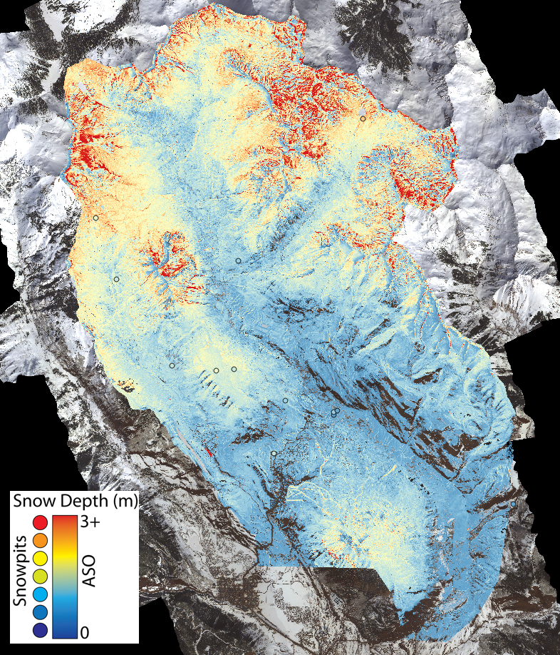
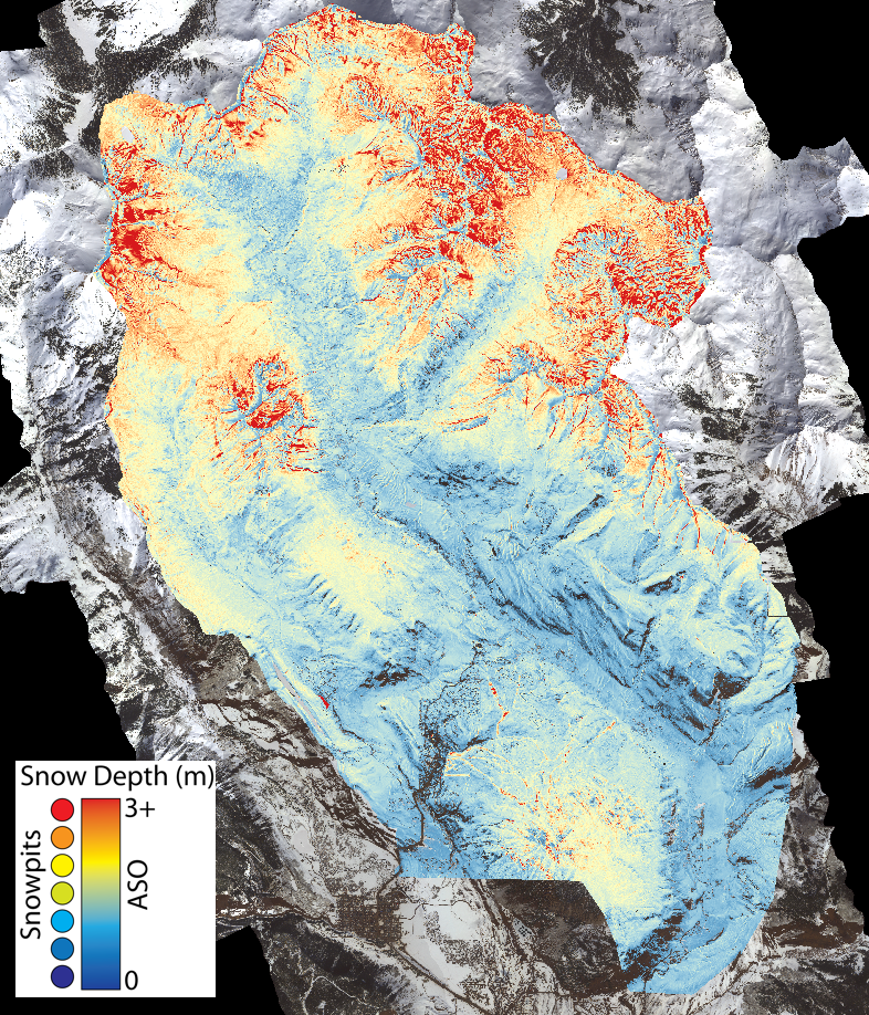
Additionally, Jeff has provided some preliminary images of snow depths associated with the boundaries of the 2016 ASO overflight.  As a reminder, snow depths are calculated via difference in LiDAR derived surface elevations measured between “snow on” and “snow free” overflights.  The Watershed SFA had already collected high-resolution “snow free” LiDAR data over a limited area, which allowed for a single “snow on” ASO flight in 2016 to determine snow depths within the East River main stem and WA Gulch drainages.  In contrast, we do not yet have high-resolution LiDAR data collected over the much larger area of investigation associated with the East River-Taylor River-Ohio Creek system.  This data — again through generous support from the state of Colorado — will be collected in September 2018, so we will have to wait until then for the larger spatial scale maps of snow depth and SWE once that “snow free” dataset is collected.

In the interim, Jeff has produced a map of the 2018 snow depths measured two weeks ago within the East River main stem and WA Gulch drainages along with the companion map for 2016.  Those images are below.  Toggling between the two shows quite clearly the differences between snow conditions in 2016 (average year) and 2018 (low snowpack year).  The open circle symbols on the 2018 map correspond to the snow pits that were dug in association with the overflight.

A second “snow on” ASO flight is planned for mid-May of this year to assess late season snow retention as a function of both elevation and landscape position.  The ability to have two time points that track the falling limb of SWE is especially exciting as it should really assist with coupling this year’s datasets to improved runoff forecast modeling approaches — although we’ll have to rely on backcast modeling this year due to the need to collect the requisite “snow free” datum in September once runoff is already completed.

Early snowmelt manipulation experiments

As most are aware, this year was our first season of experimentally manipulating snow pack along an elevation gradient to induce early snowmelt relative to adjoining control plots.  The video below provides a better visual depiction of what the manipulation experiments look like at our Pumphouse hillslope intensive study site (lower montane); similar manipulations are occurring at our upper montane, lower subalpine, and upper subalpine sites.  A suite of ground-based measurements are currently underway to examine the consequences of early melt on flows of water and nutrients within the plots, as well as the consequences for subsurface microbial activity and plant phenological behavior.  Airborne characterization approaches are also planned, with the first round of UAV-based measurements over the manipulated and control plots planned for next week.

Pat Sorenson (LBNL) has been providing daily reports of the snow melt progression, as he’s been actively sampling for the past week-plus and will continue to do so over the next week. Pat will have an opportunity to brief this group once the dust has settled — or rather once the snow has melted — next month during our next Science Community Call.  Briefly, Pat has been noting that although the snow pack continues to consolidate, settle and melt, the soils have remained quite dry and largely frozen except for the shallowest depths.  He notes that the soils are very dry to a depth of ca. 30-cm, with the persistent frozen soil layers likely inhibiting infiltration.  These frozen layers were likely more extensive this season due to the late arrival of snow and its insulating effect.  So we’re actually getting something of a two-for-one this year, given (a) low seasonal snowpack and (b) late arriving snow, which has led to a deeper frozen soil profile than typical.  Combined with the early snowmelt manipulations along the elevation gradient, the project will soon have an incredibly rich experimental dataset to examine for the next year until we do it all again.  Very exciting and again more updates to follow.

NEON Airborne Observation Platform (AOP) planning

As everyone on this list has been briefed on plans for the NEON AOP overflights and been solicited for their interest and involvement, I won’t belabor this update,  Rather, I just want to note the hard work of Dana Chadwick, Nicola Falco and Haruko Wainwright in pushing forward with all the details regarding the sampling plan and coordinating with NEON on all of the flight details.  Due to aircraft availability issues on NEON’s end, we’re now locked into the last two weeks of June, with a focus on the last week for performing the overflights.  We’d originally hoped to have the first week of July available, but as noted, the aircraft simply isn’t available.  Given the low snowpack and presumed early natural melt, we feel that for the lower elevations (lower and upper montane) the last week of June should work well insofar as meadow peak or near peak greenness is concerned.  Of course, we’re dealing with a natural system here — heavy, high elevation snow warnings are again in effect for tonight and tomorrow — so we’ll just need to wait and see what June brings us in terms of a slightly advanced growing season and its ability to coincide with NEON’s timetable.


Three Collaborative Watershed Seed Projects Funded

To catalyze engagement of new investigators and collaborative projects/initiatives, the Watershed Function SFA has selected three 1-year, collaborative mini-projects for funding. The applicants were selected for award from a large number of excellent and highly competitive proposals. The selected awards include:

“Developing capabilities for integration of microbiological and geochemical data processing” (Romy Chakraborty). This mini-project aims to demonstrate the value of connecting data infrastructures of Watershed SFA, ESS DIVE, and KBase for developing a breakthrough new capability to easily process and enable visualization of environmental microbiome data in the context of macro scale environmental dynamics.

“Establishing a new modeling capability for the East River watershed to study forest responses to perturbations” (Lara Kueppers). The objective of this mini-project is to develop a process-based forest ecosystem model that contributes to robust predictions of Rocky Mountain watershed responses to perturbations.

“Integrated Ecosystem Sensing for Tracking the Hydrodynamics of the Soil-Plant-Atmosphere Continuum and Impacts on Soil Respiration and Plant Growth” (Yuxin Wu). This project will utilize the unique capability built into the EcoSENSE SMART soils testbed for quantitative tracking of the moisture dynamics in a simulated hillslope system driven by both hydrological perturbations and plant/soil interactions, and the subsequent effects on ET and soil/plant respiration. Using a suite of sensors in a soil testbed, combined with direct sampling and characterization methods, the mini-project is expected to deliver comprehensive, dense and spatiotemporally correlated data sets to track system dynamics.

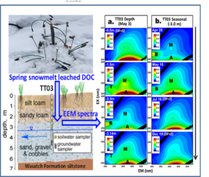
Spring Snowmelt Drives Transport and Degradation of Dissolved Organic Matter in a Semi-Arid Floodplain

Berkeley Lab geochemists and hydrologists who study a mountainous watershed near Rifle, CO, discovered that spring snowmelt is essential to the transport of freshly dissolved organic matter (DOM) from the top soil to the part of the Earth’s subsurface that lies above the groundwater table. Because dissolved organic matter undergoes biological humification over the year, these processes involving this deep vadose zone suggest an annual cycle of DOM degradation and transport at this semi-arid floodplain site.

Spring snowmelt transports fresh DOM from top soil into the deeper vadose zone, and then undergoes microbial humification process over the year (see depth and seasonal EEM spectra)

Characterizing the dynamics of dissolved organic matter in semi-arid regions of Earth’s subsurface is challenging. The authors obtained insights into transport and humification processes of DOM using several spectroscopic techniques on depth- and temporally-distributed pore-waters. This methodology can be applied to other subsurface environments for understanding DOM responses and feedbacks to earth system processes.

Summary

Scientists studying DOM in surface waters considered it to be the mobile fraction of natural organic matter that falls into or is washed into water bodies. Although it has been extensively studied over many decades, relatively little is known about the dynamics of DOM in the subsurface of semi-arid environments. In order to understand transport and humification processes of DOM within a semi-arid floodplain at Rifle, Colorado, the authors applied fluorescence excitation-emission matrix (EEM) spectroscopy, humification index (HIX) and specific UV absorbance (SUVA) for characterizing depth and seasonal variations of DOM composition. They found that late spring snowmelt leached relatively fresh DOM from plant residue and soil organic matter down into the deeper vadose zone (VZ). More humified DOM is preferentially adsorbed by upper VZ sediments, while non- or less-humified DOM was transported into the deeper VZ. Interestingly, DOM at all depths undergoes rapid biological humification processes as evidenced by the products of microbial by-product-like matter in late spring and early summer, particularly in the deeper VZ, resulting in more humified DOM at the end of year. The finding indicates that DOM transport is dominated by spring snowmelt, and DOM humification is controlled by microbial degradation. It is expected that these relatively simple spectroscopic measurements (e.g., EEM spectroscopy, HIX and SUVA) applied to depth- and temporally-distributed pore-water samples can provide useful insights into transport and humification of DOM in other subsurface environments as well.

Citation

Dong, W., J. Wan, T. K. Tokunaga, B. Gilbert, and K. H. Williams (2017). Transport and Humification of Dissolved Organic Matter within a Semi-Arid Floodplain. Journal of Environmental Sciences 57, 24-32, DOI: 10.1016/j.jes.2016.12.011

SFA Research Identifies New Microbial Players in the Global Sulfur Cycle

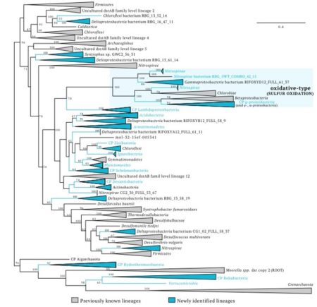
Sulfate is ubiquitous in the environment, and sulfate reduction – a key control on anaerobic carbon turnover – impacts a number of other processes such as carbon oxidation and sulfide production. Until now, sulfate reduction was believed to be restricted to organisms from select bacterial and archael phyla. But scientists at UC Berkeley have now found this ability to be more widespread. They used genome-resolved metagenomics to discover roles in sulfur cycling for organisms from 16 microbial phyla not previously associated with this process.

DsrAB protein tree showing the diversity of organisms involved in dissimilatory sulfur cycling using the dsr system.
Lineages in blue contain genomes reported in this study. Phylum-level lineages with first report of evidence for sulfur cycling are indicated by blue letters.

Sulfate-reducing bacteria are anaerobic microorganisms essential to sulfur and carbon cycling. Sulfate reduction drives other key processes and produces hydrogen sulfide, an important but potentially toxic gas present in sediments, wetlands, aquifers, the human gut, and the deep-sea. The discovery of novel microbes connected to sulfur cycling is relevant in biogeochemistry, ecosystem science and engineering, and fundamentally reshape our understanding of microbial function and capabilities associated with phylogenetic information.

Summary

Phylogenetic information shapes our expectations regarding microbial capabilities. In fact, this is the basis of currently used methods that link gene surveys to metabolic predictions of community function. Sulfate Reduction, an important anaerobic metabolism, impacts carbon, nitrogen, and hydrogen transformations in numerous environments across our planet and is known to be restricted to organisms from selected bacterial and archaeal phyla. The authors used genome-resolved metagenomic analyses to determine the metabolic potential of microorganisms from six complex marine and terrestrial environments. By analyzing >4000 genomes, they identified 123 near-complete genomes that encode dissimilatory sulfite reductases involved in sulfate reduction. They discovered roles in sulfur cycling for organisms from 16 microbial phyla not previously known to be associated with this process. Additional findings include some of the earliest-evolved sulfite reductases in bacteria, identification of a novel protein unique to sulfate reducing bacteria, and a key sulfite reductase gene in putatively symbiotic Candidate Phyla Radiation (CPR) bacteria. This study fundamentally reshapes expectations regarding the roles of a remarkable diversity of organisms in the biogeochemical cycle of sulfur.

Citation

Anantharaman, K., B. Hausmann, S.P. Jungbluth, R.S. Kantor, A. Lavy, L.A. Warren, M.S. Rappé, M. Pester, A. Loy, B.C. Thomas, and J.F. Banfield (2017). Expanded diversity of microbial groups that shape the dissimilatory sulfur cycle. The ISME journal 12, 1715–1728, DOI: 10.1038/s41396-018-0078-0

Fundamental Understanding of Engineered Nanoparticle Stability in Aquatic Environments

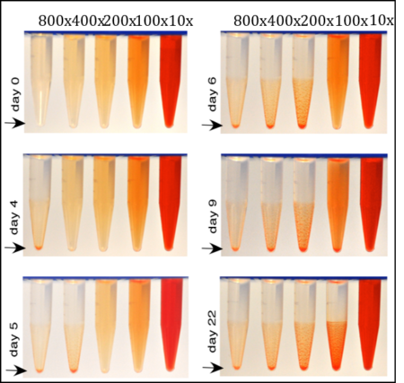
Figure. Photographs showing sedimentation of CdSe-MUA NPs as a function of dilution.

It is commonly true that a diluted colloidal suspension is more stable over time than a concentrated one, because dilution reduces collision rates, so delays formation of aggregates. However, we observed the opposite relationship between stability and concentration for some engineered ligand-coated nanoparticles.

Because the stability of NPs determines their physicochemical and kinetic behavior including toxicity, dilution induced instability needs to be understood to realistically predict the behavior of engineered ligand-coated nanoparticles in aqueous systems.

Summary

It is commonly true that a diluted colloidal suspension is more stable over time than a concentrated one, because dilution reduces collision rates of the particles, therefore delays formation of aggregates. However, this generalization does not apply for some engineered ligand-coated nanoparticles (NPs). We observed the opposite relationship between stability and concentration of NPs. We tested four different types of NPs; CdSe-11-mercaptoundecanoic acid, CdTe-polyelectrolytes, Ag-citrate, and Ag- polyvinylpirrolidone. The results showed that dilution alone induced aggregation and subsequent sedimentation of the NPs that were originally monodispersed at very high concentrations. Increased dilution caused NPs to progressively become unstable in the suspensions. The extent of the dilution impact on the stability of NPs is different for different types of NPs. We hypothesize that the unavoidable decrease in free ligand concentration in the aqueous phase following dilution causes detachment of ligands from the suspended NP cores. The ligands attached to NP core surfaces must generally approach exchange equilibrium with free ligands in the aqueous phase, therefore ligand detachment and destabilization are expected consequences of dilution. More studies are necessary to test this hypothesis. Because the stability of NPs determines their physicochemical and kinetic behavior including toxicity, dilution induced instability needs to be understood to realistically predict the behavior of engineered ligand-coated nanoparticles in aqueous systems.

Citation

Wan, J., Y. Kim, M.J. Mulvihill, and T. K. Tokunaga (2018). Dilution destabilizes engineered ligand-coated nanoparticles in aqueous suspensions. Environmental Toxicology and Chemistry. doi: 10.1002/etc.4103.

Steltzer Selected for AGU Science Advocacy Program

Heidi Steltzer of Fort Lewis College was selected to be among the first thirty advocates to serve in AGU’s Voices for Science Program.

“I applied and am grateful to have the opportunity to be part of this program,” says Steltzer. “The network creates the opportunity to share more about SFA program within AGU and hoping to explore more ways to share what we do in Colorado and beyond.”

Read the full story here.

New Approach to Predict Flow and Transport Processes in Fractured Rock uses Causal Modeling

Scientists and engineers simulate the flow of fluids through permeable media to determine how water, oil, gas or heat can be safely extracted from subsurface fractured-porous rock, or how harmful materials like carbon dioxide could be stored deep underground. Now, a scientist from Lawrence Berkeley National Lab has identified a causal relationship between gases and liquids flowing through fractured-porous media. They observed oscillating liquid and gas fluxes and pressures as the two transitioned back and forth within a subsurface rock fracture.

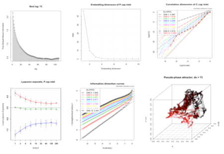
Evaluation of diagnostic parameters of deterministic chaos and 3-D strange attractor (bottom right) indicating that the system would behave within the boundaries of the attractor.

When both liquid and gas are injected into a rock fracture, the cumulative effect of forward and return pressure waves causes intermittent oscillations of liquid and gas fluxes and pressures within the fracture. The Granger causality test is used to determine whether the measured time series of one of the fluids can be applied to forecast the pressure variations in another fluid. This method could also be used to better understand the causation of other hydrological processes, such as infiltration and evapotranspiration in heterogeneous subsurface media, and climatic processes, for example, relationships between meteorological parameters—temperature, solar radiation, barometric pressure, etc.

Summary

Identifying dynamic causal inference involved in flow and transport processes in complex fractured-porous media is generally a challenging task, because nonlinear and chaotic variables may be positively coupled or correlated for some periods of time, but can then become spontaneously decoupled or non-correlated. The author hypothesized that the observed pressure oscillations at both inlet and outlet edges of the fracture result from a superposition of both forward and return waves of pressure propagation through the fracture. He tested the theory by exploring an application of a combination of methods for detecting nonlinear chaotic dynamics behavior (Figure A) along with the multivariate Granger Causality (G-causality) time series test. Based on the G-causality test, the author infers that his hypothesis is correct, and presents a causation loop diagram (Figure B) of the spatial-temporal distribution of gas, liquid, and capillary pressures measured at the inlet and outlet of the fracture. The causal modeling approach can be used for the analysis of other hydrological processes such as infiltration and pumping tests in heterogeneous subsurface media, and climatic processes.

Citation

Faybishenko, B. (2017). Detecting dynamic causal inference in nonlinear two-phase fracture flow, Advances in Water Resources 106, 111–120, DOI: 10.1016/j.advwatres.2017.02.011