Berkeley Lab

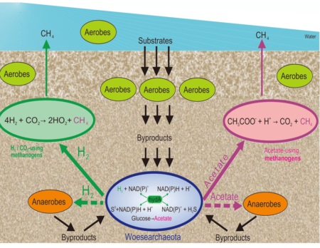
Genome analyses and metabolic reconstructions of Woesearchaeota suggest heterotrophic lifestyles that are dependent on metabolic complementarity with other microbes.

Overview of metabolic predictions of Woesearchaeota and potential syntrophic metabolisms involving a consortium of H2/CO2-using and acetate-using methanogens, Woesearchaeota, anaerobes, and/or aerobes.

Genomic analysis reveals the distribution of Woesearchaea across multiple habitat types. Metabolic reconstructions support an anaerobic, heterotrophic lifestyle albeit one with conspicuous deficiencies consistent with their inferred dependence on other microbes.

The findings provide an ecological and evolutionary framework for Woesearchaeota at a global scale and indicate their potential ecological roles, especially in methanogenesis.

Summary

A large group of genomes for Woesearchaeota were analyzed and the organisms grouped into sublineages based on their DNA sequences. These archaea were found to be widely distributed in different types of environments, but they are primarily found in anaerobic terrestrial environments. Ecological patterns analysis and ancestor state reconstruction for specific subgroups reveal that the presence of oxygen is the key factor driving the distribution and evolutionary diversity of Woesearchaeota. A selective distribution to different biotopes and an adaptive colonization from oxygen free environments is proposed and supported by evidence of the presence of ferredoxin-dependent pathways in the genomes derived from anaerobic environments. Metabolic reconstructions support heterotrophic lifestyles, with conspicuous metabolic deficiencies, suggesting the requirement for metabolic complementarity with other microbes. Lineage abundance, distribution, and co-occurrence network analyses across diverse environments confirmed metabolic complementation and revealed a potential syntrophic relationship between Woesearchaeota and methanogens.

Citation

X. Liu, M. Li, C.J. Castelle, A.I. Probst, Z. Zhou, J. Pan, Y. Liu, J.F. Banfield, J.D. Gu “Insights into the ecology, evolution, and metabolism of the widespread Woesearchaeotal lineages” Microboime, 6, DOI: 10.1186/s40168-018-0488-2
Mechanisms of Groundwater Recharge in a Snowmelt-Dominated Headwater Basin

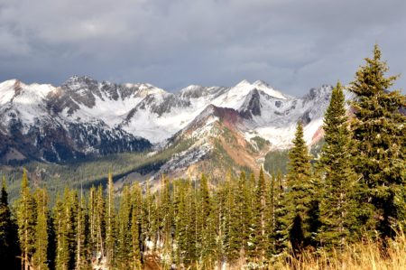
Figure 1: Landscape gradients in topography, aridity and ecotones within the East River, Colorado establish groundwater recharge mechanisms as a function of landscape position.

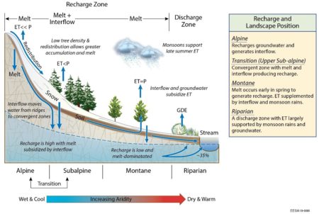
Figure 2. Conceptual model of water fluxes across landscape gradients to highlight dominant mechanisms of recharge. The transition zone is the upper subalpine and GDE = groundwater dependent ecosystem.

LiDAR-derived snow observations are combined with an integrated hydrologic model to quantify spatially and temporally distributed water fluxes across varying climate conditions, and to understand the sensitivity of groundwater generation to snow dynamics, vegetation, and topography in a Colorado River headwater basin.

The results of this work indicate that snowmelt is focused via interflow from steep, mountain ridges into the upper subalpine where slopes flatten and sparse conifer forests begin to grow. This mechanism of recharge appears resilient to drought and may buffer recharge under climate change. Seasonal snowmelt and water use by plants regulate small recharge rates in the lower elevations of this mountainous basin. Understanding the key mechanisms of groundwater recharge in headwater basins allows scientists to better predict headwater stream responses to precipitation changes, thereby improving water and environmental management.

Summary

Accumulated snow in mountain basins is a critical water source but little is known about how groundwater is influenced by changing snowpack. Airborne observations of mountain snowpack are combined with a physically-based hydrologic model to better understand how snowmelt is partitioned across the landscape and routed to streams. Results indicate that groundwater is an important and stable source of water to a mountain stream, with the relative fraction of groundwater increasing during drought as a function of increased plant water use and decreased lateral soil water flow (called ‘interflow’). The study finds that the dominant mechanism generating groundwater is topography. Specifically, snowmelt is focused via interflow from steep mountain ridges into the upper subalpine. This mechanism of recharge appears resilient to drought. Lower in the basin, snowmelt occurs before peak vegetation water use to allow for some groundwater generation. Interflow and monsoon rains then subsidize plant water use once snowmelt ceases but do not generate substantive recharge.

Citation

R. W. H. Carroll, J. S. Deems, R. Niswonger, R. Schumer, and K. H. Williams, “The Importance of Interflow to Groundwater Recharge in a Snowmelt-Dominated Headwater Basin”, Geophysical Research Letters, 46. (2019). DOI: 10.1029/2019GL082447

Susan Hubbard Elected to the American Academy of Arts and Sciences

portrait of Susan Hubbard

Susan Hubbard – Associate Lab Director Earth and Environmental Sciences Area

Susan Hubbard, Associate Laboratory Director of the Berkeley Lab Earth & Environmental Sciences Area and lead for the Watershed Function SFA, has been elected to the American Academy of Arts and Sciences, a 239-year old honorary society that recognizes accomplished scholars, scientists and artists in academia, the humanities, arts, business, and government. She is one of four Berkeley Lab scientists elected to the prestigious Academy this year. Read more »

Streamflow Partitioning and Transit Time Distribution in Snow-dominated Basins as a Function of Climate

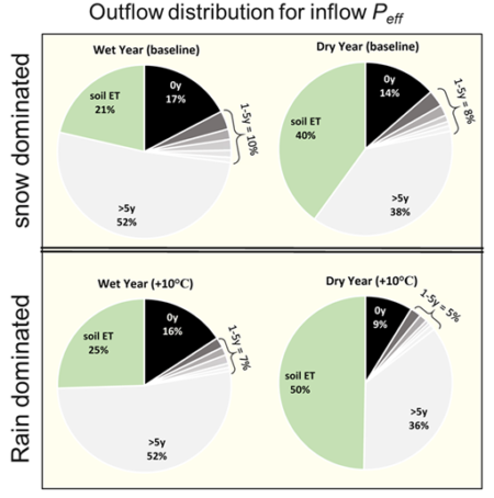
Lag of wet year (left column) and dry year (right column) inflows to exit the basin via stream discharge in the future when no temperature increase (upper row) and temperature increase =10°C (lower row).

Several models (PRMS-PEST-SAS) were coupled and applied to the snow-dominated East River Watershed to explore changes in water budgets and seasonal and annual responses in the streamflow transit time distributions.

This research was the first to apply the coupled PRMS-PEST-SAS modeling system to a large-scale (85km2) snow-dominated watershed. Results provide insight into how variation of the water budget and streamflow transit time are responding to climate change in this alpine snow-dominated system.

Summary

The modeling results show that during the snowmelt period of the year, the East River released younger water during high storage periods across seasonal and annual timescales (an “inverse storage effect”). However, wet years also appeared to increase hydrologic connectivity, which simultaneously flushed older water from the basin. During years with reduced snowpack, flow paths were inactivated and snowmelt remained in the subsurface to become older water that was potentially reactivated in subsequent wet years. Dry years were found more sensitive to warming temperatures than wet years through marked increases in the fraction of inflow lost to evapotranspiration at the expense of younger water to increase the mean age of streamflow.

Citation

Fang, Z., Carroll, R., Schumer, R., Harman, C., Wilusz, D., Williams, K., “Streamflow partitioning and transit time distribution in snow-dominated basins as a function of climate.” Journal of Hydrology. (2019) 570, 726-738. DOI: 10.1016/j.jhydrol.2019.01.029

Susan Hubbard Honored by Alameda County Women’s Hall of Fame

Susan Hubbard, Associate Laboratory Director for the Earth and Environmental Sciences Area, will be inducted into the Alameda County Women’s Hall of Fame, at an annual awards ceremony on March 30. Hubbard is being honored for her scientific contributions to key environmental challenges of our time, including the use of geophysical methods to quantify how watersheds and ecosystems are responding to changing conditions, and implications for water and biogeochemical cycles.

Susan Hubbard joins 13 other local women who represent the region’s rich diversity and a remarkable range of achievements made working to address issues such as environmental sustainability; and racial, income, and healthcare inequality; and to strengthen access to arts education and athletics programs for girls and young women.

Assessment of Spatio-temporal Variability of Evapotranspiration and Its Governing Factors in a Mountainous Watershed

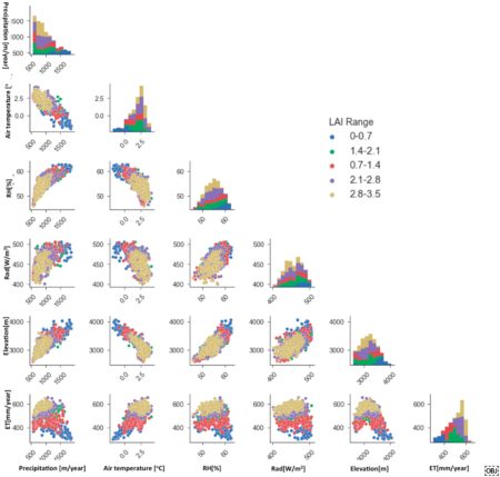
Pairwise scatter plots of meteorological forcing variables, elevation and annual evapotranspiration (ET). Different colors represent ranges of leaf area index (LAI) values. Bar plots shows the variation of meteorological forcing variables, elevation and annual ET

An important process for determining the water and energy balance at the land surface is evapotranspiration. This is one of the first studies that comprehensively investigated the spatio-temporal variations of evapotranspiration in a mountainous watershed. The results showed that the spatial variability in evapotranspiration was closely corrected with the land elevation, air temperature, and vegetation, and that evapotranspiration in areas with more finely textured soil was slightly larger than regions with coarse-textured soil.

This study presents a promising approach for assessing evapotranspiration with a high spatio-temporal resolution over watershed scales and it investigates the factors controlling spatio-temporal variations in evapotranspiration.

Summary

Evapotranspiration (ET) is a key component of the water balance in a given component of the Earth system, and it influences hydrometeorology, water resources, carbon and other biogeochemical cycles, as well as ecosystem diversity. This study sought to investigate the spatio-temporal variations of ET at the East River watershed in Colorado and analyze the factors that control these variations. The simulation results showed that 55% of annual precipitation in the East River is lost to ET, in which 75% of the ET comes from the summer months (May to September). The authors also found that the contribution of transpiration to the total ET was ~50%, which is much larger than that of soil evaporation (32%) and canopy evaporation (18%). Spatial analysis indicated that the ET is greater at elevations of 2950–3200 m and lower along the river valley (3900 m). A correlation analysis of factors affecting ET showed that the land elevation, air temperature, and vegetation are closely correlated and together they govern the ET spatial variability. The results also suggested that ET in areas with more finely textured soil is slightly larger than regions with coarse-texture soil.

Citation

Tran, A.P.; Rungee, J.; Faybishenko, B.; Dafflon, B.; Hubbard, S.S. Assessment of Spatiotemporal Variability of Evapotranspiration and Its Governing Factors in a Mountainous Watershed. Water 2019, 11, 243. DOI: 10.3390/w11020243

Nitrous Oxide Emissions from Inland Waters: Are the IPCC Estimates too High?

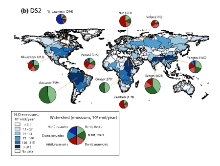
Total N2O emissions (in 106 mol N year−1) from rivers, reservoirs and estuaries combined, for major watersheds worldwide in year 2000, for default scenario 2. Pie charts show the 10 watersheds with the greatest emissions globally, with the size of the chart representing its relative emission flux compared with the other nine watersheds shown (total magnitude of flux shown in brackets after watershed name). The pie charts show the proportion of emissions from denitrification or nitrification in reservoirs, estuaries or rivers


Nitrous oxide is a key greenhouse gas, however, emissions from inland waterways remain a major source of uncertainty in greenhouse gas budgets. The Intergovernmental Panel on Climate Change (IPCC) has proposed emission factors (EFs) of 0.25% and 0.75%, though studies have suggested that both values are either too high or too low. A new approach has been developed for estimating nitrous oxide production, denitrification, and nitrification in water bodies, and water residence time is introduced as a key control on biological activity.

The new approach to modeling nitrous oxide production concludes that the IPCC EFs are likely overestimated by up to an order of magnitude.

Summary

The authors calculated global nitrous oxide (N2O) emissions from rivers, reservoirs and estuaries within a range of 10.6–19.8 Gmol N year-1 (148–277 Gg N year-1). This is more than half, and up to an order of magnitude, lower than most studies based on IPCC’s guidelines. Despite the much-reduced N2O flux estimates, the authors found that anthropogenic perturbations to river systems have doubled to quadrupled N2O emissions from inland waters. They suggest that the IPCC emissions factors of 0.25% and 0.75% are too high to be applied across all rivers, estuaries and reservoirs, and instead they estimate the following ranges of emissions factors: 0.004%–0.005% for rivers, 0.17%–0.44% for reservoirs, and 0.11%–0.37% for estuaries.

The majority of emissions in estuaries and reservoirs originate from nitrification, while denitrification tends to dominate in rivers because of the shorter residence times. Worldwide N2O emissions from inland waters are therefore expected to rise substantially in the coming decades as a result of the ongoing global boom in dam construction, which will nearly double the number of large hydroelectric dams on Earth and increase the water residence within these water bodies.

Citation

Maavara, T., Lauerwald, R., Laruelle, G.G., Akbarzadeh, Z., Bouskill, N.J., Van Cappellen, P., Regnier, P. (2019), Nitrous oxide emissions from inland waters: Are IPCC estimates too high?, Global Change Biology, doi: 10.1111/gcb.14504

Replicating subsurface processes in the laboratory

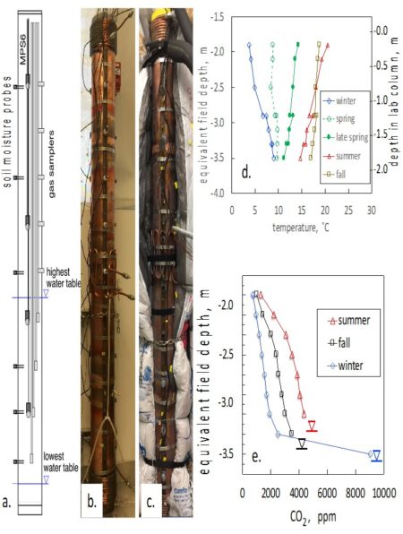
2.0 m tall laboratory sediment column and example measurements. a. instrument distribution, b. column clad with heat exchangers, c. column with insulation sleeve, d. seasonal field temperature profiles replicated in column, e. seasonal CO2 profiles from laboratory column.

Fluid flows with temperatures that are not constant are known as non-isothermal. Although changing thermal and hydrological conditions control rates of sediment biogeochemical processes in the Earth’s subsurface, these conditions are difficult to simulate in the laboratory. In this study, a novel 2 m tall column system to control time- and depth-dependent temperature profiles and water saturation was developed, which is needed to more accurately reproduce subsurface processes in the laboratory.

Temperature and moisture profiles in sediments are highly variable, and control biogeochemical processes, yet have not previously been reproduced in the laboratory. This study established field temperature and moisture profiles in a laboratory column system, and showed the importance of microbial respiration below the plant root zone by measuring CO2 production within the sediment column.

Summary

Transport between the soil surface and groundwater is commonly mediated through deeper portions of variably saturated sediments and the capillary fringe, where variations in temperature and water saturation strongly influence biogeochemical processes. Temperature control is particularly important because room temperature is not representative of most soil and sediment environments. The authors described and tested a novel sediment column design that allows laboratory simulation of thermal and hydrologic conditions found in many field settings. The 2.0 m tall column was capable of replicating temperatures varying from 3 to 22 ˚C, encompassing the full range of seasonal temperature variation observed in the deep, variably saturated sediments and capillary fringe of a semi-arid floodplain in western Colorado, United States. The water table was varied within the lower 0.8 m section of the column, while profiles of water content and matric (capillary) pressure were measured. CO2 collected from depth-distributed gas samplers under representative seasonal conditions reflected the influences of temperature and water-table depth on microbial respiration. Thus, realistic subsurface biogeochemical dynamics can be simulated in the laboratory through establishing column profiles that more accurately represent seasonal thermal and hydrologic conditions.

Citation

Tokunaga, T.K., Y. Kim, J. Wan, M. Bill, M. Conrad, and W. Dong, “Method for Controlling Temperature Profiles and Water Table Depths in Laboratory Sediment Columns. Vadose Zone Journal 17,180085 (2018). [DOI: 10.2136/vzj2018.04.0085]

October 2018 – Quick update and hunting season reminder

I wanted to send along a short “virtual site visit” presenting the recent (and ongoing) shale drilling activity at East River. This visit will find you on the Pumphouse lower montane hillslope as we core a 70m deep borehole designed to capture hydrogeochemical processes much deeper than we’ve done so to date.

In general the coring has gone well, however, the weather gods have not been cooperative, as conditions along the steep access road have been challenging. We paused drilling for safety reasons tied to the recent ~30cm of snowfall, and we will be resuming coring at two locations close to Gothic designed to collect samples from regions of the Mancos shale more heavily altered by igneous intrusives. A final update will follow once we finish up that work toward the end of this coming week.

During the drilling activity, we’ve had the pleasure of welcoming Lee Liberty of Boise State University to the watershed. Lee is a newly funded DOE University PI, and he and his team are collecting seismic reflection data along many of the roads within our study area using a novel tow-along seismic streamer. We look forward to having Lee update us on his project and findings during a future Watershed Science Community call.

Important Health and Safety Reminders

The first rifle hunting season starts today Saturday Oct. 13 and runs through Oct. 17th; the second rifle season is Oct. 20-28. Please wear an orange vest, hat or jacket for visibility and safety. Like other personal protective equipment, the costs of these vests, hats, etc. are reimbursable. Please stop by the local hardware store, Walmart, or sporting goods store to purchase these supplies if you will be in the field during hunting season.

Related to this, I wanted to emphasize the importance of suitable field gear. We recently had an incident where one of our employees fell while trying to cross the East River near the Rustlers Gulch access point. As many know, this crossing has become challenging over the past year due to a large beaver dam immediately downstream of the crossing. Multiple cars have flooded their engines trying to cross earlier in the year, as the water line was above the engine air intake. As a result, many folks are crossing the river by foot upstream using logs and rocks to avoid getting their feet a bit wet. Such crossings can be challenging — the proverbial falling off a log. For safety reasons, such crossings should be made using appropriate footwear, such as hip boots, waders or water shoes, in order to minimize risk associated with walking the tightrope so to speak. Please don’t risk an injury just trying to keep your toes dry. As with the orange vests and hats, the costs for proper field footwear are reimbursable expenses.

Sustainable Remediation of Complex Environmental Systems: Key Recent Technical Advances

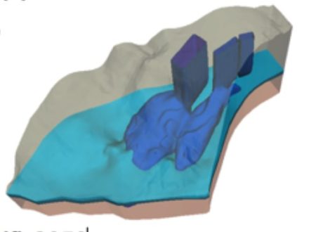
Simulated uranium plume (concentration>1×10⁻⁶mol/L) in 3D at the Savannah River Site F-Area in 2050. The sky-blue region is the low permeable Tan Clay Zone, which separates the upper and lower aquifers.

This book chapter provides an overview of the key recent scientific advances to support sustainable remediation in complex geological systems demonstrated at the Savannah River Site F-Area, including site characterization techniques, hydrological and geochemical model developments and numerical simulations.

We have developed various subsurface characterization and modeling technologies to improve the predictive understanding of the groundwater contaminant plumes in complex geological systems. The technologies have been demonstrated at the Department of Energy’s Savannah River Site.

Summary

Groundwater remediation has been evolved recently with increased focus on sustainable approaches such as in situ treatments and natural attenuation. However, leaving contaminants in subsurface requires the increased burden of proof to show that plumes are stable and residual contaminants do not pose a significant health risk. At the Department of Energy’s Savannah River Site, we have developed and demonstrated various characterization and modeling technologies to provide the predictive understanding of the contaminant plume migration, including (1) a multiscale data integration method to integrate surface seismic and borehole datasets that have different resolution and spatial coverage, (2) a novel surface complexation model to describe pH-dependent uranium sorption behavior based on readily available datasets, and (3) a reactive transport modeling and uncertainty quantification framework to predict the future uranium plume behavior and to identify key parameters on the future uranium concentration. These technologies are expected to transform groundwater remediation at many other sites.

Citation

Wainwright, H. M.; Arora, B.; Faybishenko, B.; Molins, S.; Hubbard, S. S.; Lipnikov, K.; Moulton, D.; Flach, G.; Eddy-Dilek, C.; Denham, M. (2018), Sustainable Remediation in Complex Geologic Systems, The heaviest metals: Science and technology in Actinides and beyond.