Berkeley Lab

Steefel leads new project to Advance Watershed System Understanding through Exascale Simulation and Machine Learning

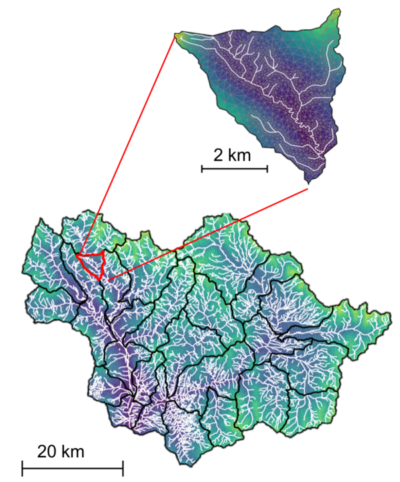
The ExaSheds project is the first-ever systematic effort to advance powerful machine learning and Exascale computing to transform our ability to predict watershed behavior and increase the use of ever-larger and more-complex data obtained from watershed field observations.


Carl Steefel leads the new ExaSheds project, which will develop groundbreaking capabilities critical for transforming our ability to predict how watersheds are responding to a rapidly changing environment. It is expected that the developed ExaSheds capabilities will be useful at the East River watershed site as well as to watersheds throughout the world. Read more »
July 24 – Virtual Site Visit

With the onset of warm weather, field work activities in the watershed have really ramped up over the past month.  Both Berkeley Lab staff and our DOE-funded University and USGS cohort have been working at multiple sites to quantify the consequences of early snowmelt on ET tied to the manipulation experiments, install sap flow sensors on multiple tree species at multiple sites, examine shale bedrock properties, measure stream discharge and build new rating curves, and much, much more.  Additionally, members of the SLAC “Groundwater Quality” SFA — led by PI John Bargar — have greatly ramped up their research footprint in the Slate River valley.  We look forward to hearing an update from John this fall on their research progress.

Stream flows are now sufficiently low as to make wading and working within the stream corridor safe.  That said, workers crossing and working in streams are reminded to exercise care and to wear appropriate gear, such as waders, wading boots, and hiking pole(s).  A virtual site visit can be found here of my recent trip to the large, off-channel wetland complex upstream of the Pumphouse.  This site has been an important testbed for the DOE-funded research project led by Marty Briggs (USGS) and his co-investigators Fred Day-Lewis (USGS) and Lee Slater (Rutgers Univ.).  Marty will update us on this work during next week’s call.

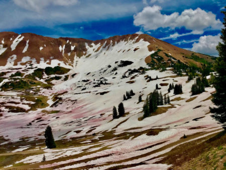
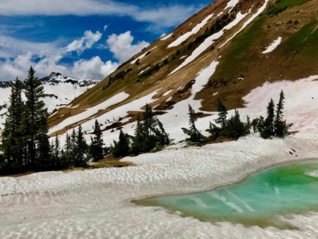
Road access to Schofield Pass from Gothic via Emerald Lake is still not possible given persistence of the snow plug.  Access to the Paradise Divide and our alpine study site on Cinnamon Mountain is possible, however, lingering snow in the Paradise Basin and the approach to Schofield Pass from the north is still preventing vehicular travel at last report.  Below are two beautiful shots of Paradise Basin and the mineralized faces of Mt. Baldy and Cinnamon Mountain courtesy of Rosemary Carroll (DRI).


Wildflower season is at or near peak at many locations within the watershed.  For those who have recently been at East River or will be soon, it’s a glorious time to be working at the site.
With the flowers come the arrival of the nuisance flies, which aren’t a problem if you’re actively moving or it’s windy.  If it’s calm or you’re working in one place, I recommend lightweight, long-sleeve shirts and pants and possibly face netting.  We have had one instance in the past where bites from these flies triggered an allergic reaction, so definitely be mindful of their potential impact while you’re working.

The US Forest Service (USFS) has released a vegetation management plan for the Taylor River Basin that may be of considerable interest to members of our Science Community.  The plan can be found here and it may represent a strategic opportunity for catchment scientists on our extended team to investigate the impacts of forest management practices on flows of water and nutrients.  Interested individuals should feel free to reach out to me and I’m happy to help make arrangements to speak with USFS staff in person or remotely.  This could be a strategically important opportunity given our team’s current expansion into the Taylor River Basin tied to the NASA Airborne Snow Observatory data being collected there, as well as work led by David Gochis (NCAR) that he will describe during next Tuesday’s call.

Working with the USGS Colorado Water Science Center, we have submitted the Gunnison River Basin as one of four HUC-4 basins that headwater in the state as possible candidates for the next USGS Next-Generation Water Observing System (NGWOS).  The other candidate basins include the Colorado River main stem, the San Juan, and the upper Rio Grande.  The NGWOS program is designed to “provide high-fidelity, real-time data on water quantity and quality necessary to support modern water prediction and decision support systems for water emergencies and daily water operations” with the first NGWOS basin being the Delaware River. Should one of the Colorado basins be chosen, it would represent an excellent opportunity for further engagement between our Science Community, the two DOE SFA programs, and our University colleagues to participate in an important USGS-led national effort.  I will keep this group updated on the selection process as it proceeds.

Vehicular access to Snodgrass Mountain is currently not allowed.  RMBL is currently sorting out land ownership and access issues for the road used for servicing the RMBL weather station at the top of the mountain.  While this road has been used by our group in the past to ferry heavy equipment and would be needed for any future drilling activities in 2020 and beyond, no vehicular access is allowed until further notice.  Per my last message to the group, all Snodgrass research plans and activities must be clearly communicated with ample notice to Jennie Reithel (RMBL) and myself.

Restrictions are now in place for the Crested Butte Mountain Resort (CBMR) parking lot at their maintenance & operations building.  This lot is where our team parks, stages, and drives through en route to the Pumphouse site.  Outside of normal business hours for CBMR, which run 7 days a week, a locked red gate may now block vehicular access to Pumphouse.  Tied to our Memorandum of Agreement (MOA) with CBMR, I do have the gate code and will provide it to those staff working at the Pumphouse site outside of normal business hours.  Please contact me in advance if there’s a likely need to work at times when the gate may be locked.  Note that with the recent purchase of CBMR by Vail Resorts, I am currently renewing the MOA and will plan to leave hard copies of it at the SFA Red Lady House for personnel to keep in their vehicles when accessing the site.  We’ve not had any issues to date, and I’d like to keep it that way given the importance of CBMR as a local stakeholder.

July 8 – Virtual Site Visit

Field work activities have started to ramp up considerably within the watershed having been delayed by a cool, wet spring and persistent high elevation snow. The rivers in the greater East River watershed continue to run very high and cold and “in stream” work is still considered extremely hazardous and should be avoided for at least another couple of weeks.

To get a sense of the current river conditions at the Pumphouse and specifically “Meander A” you’ll find a July 1st Virtual Site Visit here:

Recent emails to the group and the last Science Community call highlighted the significant avalanche activity this winter / spring in the Elk Mountains. While some of you have now personally seen the outcome of such slides in the vicinity of Gothic and the Judd Falls trailhead, I wanted to share a drone video of debris associated with a truly massive avalanche on the north-facing side of the Elk Mountains in the Conundrum Creek drainage. For those with an interest in avalanches and forest (re)structuring, this video really highlights the connection between the two. It also presents the value of forward-thinking engineering design in avalanche country. Very impressive.

For our long-standing Rifle community members, I wanted to pass along a recent story in the New York Times that highlights some of the recent work of Prof. Derek Lovley’s lab. It’s quite well done and it’s great to see that work highlighted nationally. Derek and his partners from Innosense, LLC are currently engaged at East River tied to a DOE SBIR project developing novel biosensors, so the NYTimes piece is both timely and a nice way to remind the Science Community of his ongoing role in the watershed.

Lastly, I wanted to send a reminder about the critical importance of running field experimental plans through both Jennie Reithel the RMBL Science Director, and myself well in advance of undertaking them. While we’ve generally done a good job with this, it’s imperative to remember that should your planned field dates shift, you need to notify Jennie (and myself) of this shift, as it may impact other field projects or overlap with periods of time in the East River that are heavily impacted by tourists etc. This is especially true this year, as persistent snow in the high country is consolidating visitors to a handful of lower elevation sites, such as Snodgrass. Our Science Community is part of a much bigger community of East River stakeholders — including local citizens and visitors — and we need to be cognizant of how our activities are perceived beyond just our immediate team. Jennie is a critical component for ensuring we present the best version of ourselves as scientists to this broader community, so again please do run all planned field activities through her in advance and notify her of dates changes in your plans should they occur.

Predictive Numerical Modeling Provides Insights into Changes in Contaminant Mobility under Increased and Extreme Precipitation Scenarios

Impact of one-year extreme recharge (assumed in 2020) on well concentrations. e is the fractional increase in recharge

Climate change – through precipitation regime shifts or extreme precipitation events – can have a significant impact on the mobility of residual contaminants at sites where remediation solutions and management are based on an expected range of site conditions. This study used numerical simulations to evaluate and quantify the impact of such shifts or events; in particular, the competing factors of dilution and re-mobilization. Results showed that contaminant concentrations immediately decreased following extreme precipitation events due to dilution, but subsequently increased several years later due to re-mobilization of contaminants from the source zone.

The impact of changes in contaminant mobility and concentration due to extreme precipitation and shifts in the precipitation regime were found to last for several decades, depending on monitoring well locations, performance metrics and site conditions. The results of this study suggested critical considerations for the design of long-term engineered systems such as surface capping structures, and for not only monitoring their efficacy, but also for defining threshold levels of precipitation that could drastically alter the system behavior.

Summary

Through numerical modeling of un-saturated/saturated flow and transport, a team of scientists evaluated the effect of increasing and decreasing precipitation, as well as the impact of potential failure of surface barrier systems. The approach was demonstrated using a case study involving the simulation of the transport of non-reactive radioactive tritium at the U.S. Department of Energy’s Savannah River Site F-Area. Results showed that such hydrological changes significantly impact groundwater concentrations. After an initial dilution effect, the modeling results identified a significant concentration increase some years later as a consequence of contaminant mobilization. Threshold levels of precipitation were identified, above which the contaminant concentration/exports were affected. The results suggest the importance of source zone monitoring to detect re-mobilization and highlight surface barrier design requirements needed to reduce the impact of hydrological changes.

Citation

Libera, A., de Barros, F. P., Faybishenko, B., Eddy-Dilek, C., Denham, M., Lipnikov, K., Moulton, J. D., Maco, B. & Wainwright, H. (2019). Climate change impact on residual contaminants under sustainable remediation. Journal of Contaminant Hydrology, 103518, DOI: 10.1016/j.jconhyd.2019.103518

Hydrogen-based Metabolism as an Ancestral Trait in Phyla Related to the Cyanobacteria

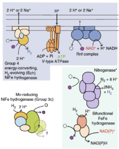
Key components of energy metabolism in Riflemargulisbacteria including different kinds of hydrogenases, a nitrogenase, and other protein complexes involved in energy conservation. Modified from the original publication (above).

Bacteria from multiple phyla related to Cyanobacteria were genomically described using metagenomics and single cell genomics, and genes were predicted for all genomes. Metabolic capacities, some featuring novel complexes, were predicted using genome-based analyses. Capacities were mapped across lineages to detect environment- and lineage-specific lifestyles.

The results suggest that the common ancestor of all of the phyla investigated may have been an anaerobe in which fermentation and H2 metabolism were central metabolic features. Capacities of phylogenetic neighbors to Cyanobacteria (the group in which oxygenic photosynthesis arose), such as Margulisbacteria, Saganbacteria, Melainabacteria and Sericytochromatia, constrain the metabolic platform in which aerobic respiration arose. The evolution of aerobic respiration was likely linked to the origins of oxygenic Cyanobacteria.

Summary

Margulisbacteria (RBX-1 and ZB3), Saganbacteria (WOR-1), Melainabacteria, and Sericytochromatia, close phylogenetic neighbors to Cyanobacteria, may constrain the metabolic platform in which aerobic respiration arose. In this study, the authors predict that sediment-associated Margulisbacteria have a fermentation-based metabolism featuring a variety of hydrogenases, a streamlined nitrogenase, and electron bifurcating complexes involved in cycling of reducing equivalents. The genomes of ocean-associated Margulisbacteria encode an electron transport chain that may support aerobic growth. Some Saganbacteria genomes encode various hydrogenases, and others may have the ability to use O2 under certain conditions via a putative novel type of heme copper O2 reductase. Similarly, Melainabacteria have diverse energy metabolisms and are capable of fermentation and aerobic or anaerobic respiration. The ancestor of all of these groups may have been an anaerobe in which fermentation and H2 metabolism were central metabolic features. The ability to use O2 as a terminal electron acceptor must have been subsequently acquired by these lineages.

Citation

P. B. Matheus Carnevali, F. Schulz, C. J. Castelle, R. S. Kantor, P. M. Shih, I. Sharon, J. M. Santini, M.R. Olm, Y. Amano, B.C. Thomas, K. Anantharaman, D. Burnstein, E. D. Becraft, R. Stepanauskas, T. Woyke, and J. F. Banfield, “Hydrogen-based metabolism as an ancestral trait in lineages sibling to the Cyanobacteria”. Nature Communications, 10, 463 (2019), doi: 10.1038/s41467-018-08246-y

Using Remote Sensing to Determine the Relationship Between Soil Conditions and Plant Communities

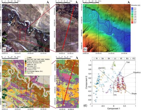
(a) View of the hillslope-floodplain area study acquired by Worldview-2 satellite, including the ERT transect (in red color); (b) Digital terrain model capturing the microtopography; (c) Map of the spatial distribution of plant communities at sub-meter resolution; (d) Biplot based on principal component analysis that shows the co-variability between plant community, soil electrical conductivity, and topographical metrics. Legend: riparian shrubland (RI), sagebrush (SA), shrubland (SH), lupine meadow (LU), veratrum (VE), bunchgrass meadow (BU), and forb (FO).

Integration of high-resolution remote sensing and geophysical data for the investigation of the co-variability between plant community distributions, soil electrical conductivity, and microtopographical properties was used to assess the spatial organization of meadow plants within a floodplain-hillslope system at the East River watershed in Colorado.

This study fused satellite and Light Detection and Ranging (LiDAR) data, along with site characterization data to arrive at estimates of key meadow communities at high resolution. This type of information could be used on large scales to provide information on the spatial variability of soil properties, and it could also be used to capture plant community responses to perturbations over significant landscape areas.

Summary

In this study, the authors aimed to understand how soil and topographic properties influence the spatial distribution of plant communities within a floodplain-hillslope system, located in the mountainous East River watershed in Colorado. Watersheds are vulnerable to environmental change, including earlier snowmelt, changes in precipitation, and temperature trends, all of which can alter plant communities and associated water and nutrient cycles within the watershed. However, tractable yet accurate quantification of plant communities is challenging to do at a scale that also permits investigations of the key controls on their distribution. In this work, the team developed a framework that uses a new approach to estimate plant distributions, one which exploits both remote sensing (satellite) images and surface geophysical data. Joint consideration of the above-and-belowground datasets allowed the team to characterize both plant and soil properties at high spatial resolution and to identify the main environmental controls for plant distribution. The results show that soil moisture and microtopography strongly influence how plant communities are spatially distributed. Considering that each community responds to external perturbation in a different way, this method can be used within a multi-temporal framework to characterize environmental heterogeneity and to capture plant responses caused by climate-related perturbations.

Citation

N. Falco, H. M. Wainwright, B. Dafflon, E. Léger, J. Peterson, H. Steltzer, C. Wilmer, J. C. Rowland, K. H. Williams, and S. S. Hubbard, “Investigating Microtopographic and Soil Controls on a Mountainous Meadow Plant Community Using High – Resolution Remote Sensing and Surface Geophysical Data.” Journal of Geophysical Research: Biogeosciences, (2019). DOI: 10.1029/2018JG004394

The Composition of Microbial Communities in Soils is Shaped by Proximity to Surface Water, Groundwater, and Weathered Bedrock

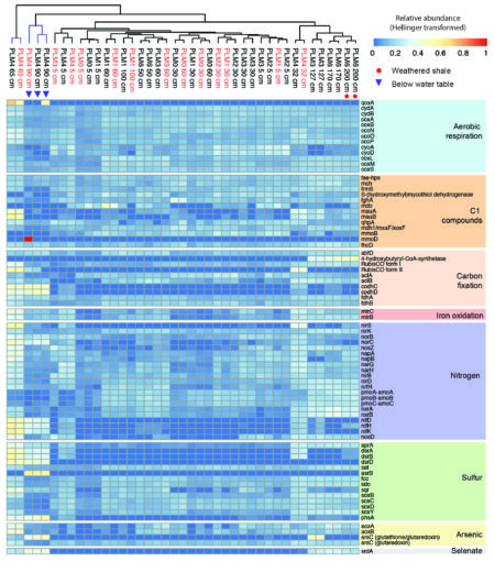
Spatial abundance of genes central to metabolic pathways. Samples from the floodplain (blue colored clade) are distinct from samples of the hillslope (black colored clade), particularly with respect to carbon fixation and selenate reduction. Furthermore, weathered shale samples at PLM6 are distinct from other hillslope samples.

Based on a hillslope to riparian zone transect study, the distance from surface water, the proximity to groundwater, and the underlying weathered shale were found to strongly impact microbial community structure and metabolic potential. Microbes from Candidate phyla were found to consistently increase in abundance with increasing depth; however, Candidate Phyla Radiation bacteria were only found in the riparian zone saturated sediments.

The results of this work demonstrate that riparian zone and deep soil microbial communities are functionally differentiated from shallow hillslope communities based on their metabolic capacity. These findings suggest that the drivers of community composition and metabolic potential identified along this representative hillslope-to-floodplain transect will be key for predicting patterns across similar such transects within mountainous systems.

Summary

Within mountainous watersheds, microbial communities impact water chemistry and element fluxes as water from precipitation events discharges through soils and underlying weathered rock; however, there is limited information regarding the structure and function of these communities. Within the East River, CO watershed, a team of scientists conducted a depth-resolved, hillslope to riparian zone transect study to identify factors that control how microorganisms and their functionality are distributed. Metagenomic and geochemical analyses indicate that distance from the East River and proximity to groundwater and underlying weathered shale strongly impact microbial community structure and metabolic potential. Riparian zone microbial communities are compositionally distinct from the phylum to species level from all hillslope communities. Bacteria from phyla lacking isolated representatives were found to consistently increase in abundance with increasing depth, but Candidate Phyla Radiation bacteria were only found in the riparian zone saturated sediments. Riparian zone microbial communities were found to be functionally differentiated from hillslope communities based on their capacities for carbon and nitrogen fixation and sulfate reduction. Selenium reduction was found to be prominent at depth in weathered shale and saturated riparian zone sediments and could impact water quality. The results suggest that the drivers of community composition and metabolic potential identified throughout the studied transect would be key for predicting patterns across the larger watershed hillslope system.

Citation

Lavy A., McGrath D. G., Matheus Carnevali P. B., Wan J., Dong W., Tokunaga T. K., Thomas B. C., Williams K. H., Hubbard S. S., Banfield J. F. (2019) Microbial communities across a hillslope-riparian transect shaped by proximity to the stream, groundwater table, and weathered bedrock. Ecology and Evolution. DOI: 10.1002/ece3.5254

May 2019 – Updates, virtual site visits, and more

As it’s been some time since my last email update with news, updates, and safety reminders, I wanted to get a condensed version out as we move into the busy field season.

  • Following what was a big snow year for Colorado and Crested Butte, we’ve had a relatively cold and wet May that has suppressed melt and runoff.  From a water perspective, this is very good news, with the exception of runoff forecasting, which has been hampered by the unseasonably cool weather.  From a field access perspective, however, it’s proving to be challenging.  We anticipate that the County Road out to Gothic will be open soon, although vehicular access won’t be possible past RMBL for the foreseeable future.  Those with field sites upstream of Gothic will need to be prepared to hike, ski, snowshoe, as warranted.
  • We successfully completed the first Airborne Snow Observatory (ASO) flight of the year during the so-called “Peak Snow Water Equivalent” period in early April.  For those who haven’t yet enjoyed the opportunity to dig snow pits tied to these ASO overflights, I wanted to provide two short “virtual site visits” depicting both pit digging and snow sampling.  I hope you enjoy and can envision yourselves helping out next year!  A second ASO flight is being used to evaluate regions of preferential snow retention within the Ohio Creek-East River-Taylor River study area; it’s planned for this Sunday-Monday (weather allowing).
  • Snow conditions at the higher elevations are still quite deep for this time of year.  Indeed, for those with field sites at higher elevations, access will be challenging for quite a while to come. Courtesy of Wendy and Tony Brown, photos of current conditions at the Lower Subalpine and Upper Subalpine field sites along the Washington Gulch elevation gradient will give you a virtual sense of what can be expected if you’re planning to head up soon.  For those on Kate Maher’s (Stanford) team, it might be worth looking at those from the Upper Subalpine site, as that’s the approach area for your Rock Creek study area.
  • Snow conditions at the two SNOTEL stations (Butte and Schofield) tell a similar story.  Below is a very nice figure prepared by Rosemary Carroll that depicts a variety of recent snow years for comparison with 2019 along with corresponding river discharge for the East River at Almont.  The aforementioned cool, wet weather in May has suppressed runoff of late; however, a lot of snow-bound water remains, and if we get a sustained warm up period, this melt could make for some very abrupt increases in discharge and flooding / over-banking along the river bottoms.
  • Related to these large increases in discharge, please use EXTREME caution when working along the river corridor.  Indeed, unless absolutely essential and your training permits working within the river during the rising and falling limbs of the hydrograph, please stay out of the rivers at this time.  Given her depth of knowledge and involvement with the stream gauging network, please reach out to Rosemary Carroll (Rosemary.Carroll@dri.edu) should you have specific questions about river conditions and whether access is (un)safe.
  • In April, we had an exciting field deployment of a novel electrochemical monitoring system performed as part of DOE’s Small Business Innovative Research (SBIR) Program.  The project, led by Dr. Don Nuzzio, is described more fully in this new “Meet the Scientist” video.  In brief, it uses a submerged electrode system to electrochemically quantify a variety of aqueous metals and compounds in various streams within the watershed.
  • Field teams from the SLAC SFA led by John Bargar are currently in the field.  Additionally, various members of our collaborating groups from Stanford, UMASS, Univ. Illinois – Chicago, and elsewhere are arriving daily and starting up the field work season.  Stay safe, warm, and dry out there folks!
  • With the incredible help of Chelsea Wilmer, Amanda Henderson, and Tony Brown, we’ve had tremendous success this year with the early snowmelt manipulation experiments.  Snowmelt tarps have been removed at both the Lower and Upper Montane sites with significant advancement of the first snow-free day at both locations.  The tarps are still deployed at the Lower Subalpine site with roughly 40-50 cm of snow still remaining underneath the tarped areas; un-tarped control areas have 100 cm remaining.  Tarps have yet to be deployed at the Upper Subalpine site given >240 cm of snow still remaining at that elevation.
  • As food for thought, I wanted to share a well-produced, short video describing ranching-related research activities pursued by the Archbold Biological Station (Florida) at their Buck Island Ranch   Along with my fellow RMBL Board members, I had the opportunity to visit Buck Island recently and I couldn’t have been more inspired by their studies investigating the many positive benefits of well managed land use on both hydrologic and biogeochemical processes.  Given the strong legacy of ranching and irrigated agriculture in the East River and Ohio Creek drainages, the Buck Island model might potentially represent an interesting one with which to engage local ranchers in our watershed.  For those with an interest in such topics or with faculty friends working in this space, I might suggest reaching out to myself and Ian Billick (ibillick@gmail.com), Executive Director of RMBL.
  • Lastly, I wanted to share a photo forwarded to me yesterday by Rosemary that highlights the beauty of the site this time of year.  It was taken by Connor Scalbom, who is doing some amazing photographic work in the valley.

New evolutionary patterns and diversity revealed from genome-resolved metagenomics.

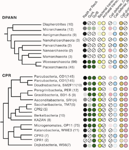
DPANN and CRP are major groups within the tree that are predicted to be microbial symbionts

Understanding of microbial diversity has been dramatically expanded through analysis of genomes from groups of organisms previously inaccessible to laboratory-based identification and characterization.

Analysis of genomes from little-explored subsurface environments has uncovered new evolutionary patterns, including a group that may be ancestral to Eukaryotes, humanity’s own branch of life. Also evident are two major radiations of microorganisms that appear to live primarily via symbiosis with other bacteria and archaea. These organisms have ecosystem importance via impacts on their hosts, geochemical cycling, and potentially play roles in agriculture and human health.

Summary

The tree of life is arguably the most important organizing principle in biology and perhaps the most widely understood depiction of the evolutionary process. It explains how humanity is related to other organisms and where we may have come from. The tree has undergone some tremendous revolutions since the first version was sketched by Charles Darwin. A major innovation was the construction of phylogenetic trees using DNA sequence information, work that enabled the definition of the three domains of life: Bacteria, Archaea, and Eukaryotes. More recently, the three-domain topology has been questioned, and eukaryotes potentially relocated into the archaeal domain. Beyond this, and as described here, cultivation-independent genomic methods that access sequences from organisms that resist study in the laboratory have added many new lineages to the tree. Their inclusion clarifies the minority of life’s diversity represented by macroscopic, multi-celled organisms and underscores that humanity’s place in biology is dwarfed by bacteria and archaea.

Citation

C. J. Castelle and J. F. Banfield, “Major New Microbial Groups Expand Diversity and Alter our Understanding of the Tree of Life.” Cell, 172, 1181-1197 (2018) DOI: 10.1016/j.cell.2018.02.016

Recovery of Genomes from Complex Environmental Samples is Greatly Improved using a Novel Analytics Tool

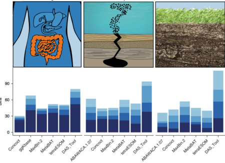
The number of high-quality genomes with low contamination from three ecosystems of varying complexity. Bin completeness increases with increasing shade of blue.

Genomes reconstructed directly from DNA sequences sampled from natural environments have revolutionized scientific understanding of microbial diversity and evolution. While this process can be difficult, a new automated method called DAS Tool integrates a flexible number of binning algorithms to calculate an optimized, non-redundant set of bins from a single assembly, thereby greatly improving the recovery of genomes from natural environments.

The recovery of genomes, especially from complex environments such as soil, will be facilitated by the new automated DAS Tool.

Summary

Understanding of the metabolic capacities of microorganisms in natural environments is critical to prediction of ecosystem function. Analysis of organism-specific metabolic pathways and reconstruction of community interaction networks requires high-quality genomes. However, existing binning methods often fail to reconstruct a reasonable number of genomes and report many bins of low quality and completeness. Furthermore, the performance of existing algorithms varies between samples and environment types. A dereplication, aggregation and scoring strategy, DAS Tool, was developed. This algorithm combines the strengths of a flexible set of established binning algorithms. DAS Tool applied to a constructed community generated more accurate bins than any automated method. Indeed, when applied to environmental and host-associated samples of different complexity, DAS Tool recovered substantially more near-complete genomes, including those for organisms from previously unreported lineages, than any single binning method alone. The ability to reconstruct many near-complete genomes from metagenomics data will greatly advance genome-centric analyses of ecosystems.

Citation

C.M.K. Sieber, A.J. Probst, A. Sharrar, B.C. Thomas, M. Hess, S.G. Tringe, and J.F. Banfield “Recovery of genomes from metagenomes via a dereplication, aggregation and scoring strategy”, Nature Microbiology, 3, 836 (2018) DOI: 10.1038/s41564-018-0171-1